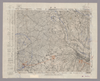
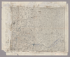
関東地方の旧版地形図モザイク Last modified about 2 years ago. Depicts : 1920
78 maps (78 maps rectified 100%)
Download KML |
|
|
関東地方旧版地形図
関東地方の旧版地形図モザイク Last modified about 2 years ago. Depicts : 1920 78 maps (78 maps rectified 100%) Download KML | |

| Map | Title | Year | Last Updated | Status |
|---|---|---|---|---|
|
この地図の作成に当たっては、国土地理院長の承認を得て、同院発行の20万分の1地勢図及び5万分の1地形図を使用した。(承認番号 平30情使、 第1148号) (In 1 layer)
Links: Source / Biblio Ref
|
1947 | about 2 years ago | 4 control points |
|
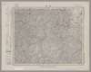
Image from the Map Collections courtesy Stanford University Libraries, licensed under a Creative Commons Attribution-Noncommercial 3.0 Unported License. © Stanford University. 【図幅名】 寄居 【測量時期】 明治40年測図/昭和4年修正/昭和9年要部修正/昭和14年部分修正 【発行時期】 昭和15年8月発行 【記号】 宇都宮16号 【測量機関】 大日本帝国陸地測量部 【備考】 (In 1 layer)
Links: Source / Biblio Ref
|
about 1 month ago | 4 control points | |
|
この地図の作成に当たっては、国土地理院長の承認を得て、同院発行の20万分の1地勢図及び5万分の1地形図を使用した。(承認番号 平30情使、 第1148号) (In 1 layer)
Links: Source / Biblio Ref
|
1947 | about 4 years ago | 4 control points |
|
この地図の作成に当たっては、国土地理院長の承認を得て、同院発行の20万分の1地勢図及び5万分の1地形図を使用した。(承認番号 平30情使、 第1148号) (In 1 layer)
Links: Source / Biblio Ref
|
1947 | over 5 years ago | 4 control points |
|
この地図の作成に当たっては、国土地理院長の承認を得て、同院発行の20万分の1地勢図及び5万分の1地形図を使用した。(承認番号 平30情使、 第1148号) (In 1 layer)
Links: Source / Biblio Ref
|
1947 | over 5 years ago | 4 control points |
|
この地図の作成に当たっては、国土地理院長の承認を得て、同院発行の20万分の1地勢図及び5万分の1地形図を使用した。(承認番号 平30情使、 第1148号) (In 1 layer)
Links: Source / Biblio Ref
|
1947 | over 5 years ago | 4 control points |
|
この地図の作成に当たっては、国土地理院長の承認を得て、同院発行の20万分の1地勢図及び5万分の1地形図を使用した。(承認番号 平30情使、 第1148号) (In 1 layer)
Links: Source / Biblio Ref
|
1947 | over 5 years ago | 4 control points |
|
この地図の作成に当たっては、国土地理院長の承認を得て、同院発行の20万分の1地勢図及び5万分の1地形図を使用した。(承認番号 平30情使、 第1148号) (In 2 layers)
Links: Source / Biblio Ref
|
1948 | about 2 years ago | 4 control points |
|
この地図の作成に当たっては、国土地理院長の承認を得て、同院発行の20万分の1地勢図及び5万分の1地形図を使用した。(承認番号 平30情使、 第1148号) (In 2 layers)
Links: Source / Biblio Ref
|
1947 | about 2 years ago | 4 control points |
|
この地図の作成に当たっては、国土地理院長の承認を得て、同院発行の20万分の1地勢図及び5万分の1地形図を使用した。(承認番号 平30情使、 第1148号) (In 1 layer)
Links: Source / Biblio Ref
|
1946 | about 2 years ago | 4 control points |
|
この地図の作成に当たっては、国土地理院長の承認を得て、同院発行の20万分の1地勢図及び5万分の1地形図を使用した。(承認番号 平30情使、 第1148号) (In 1 layer)
Links: Source / Biblio Ref
|
1947 | about 2 years ago | 4 control points |
|
この地図の作成に当たっては、国土地理院長の承認を得て、同院発行の20万分の1地勢図及び5万分の1地形図を使用した。(承認番号 平30情使、 第1148号) (In 1 layer)
Links: Source / Biblio Ref
|
1947 | about 2 years ago | 4 control points |
|
この地図の作成に当たっては、国土地理院長の承認を得て、同院発行の20万分の1地勢図及び5万分の1地形図を使用した。(承認番号 平30情使、 第1148号) (In 1 layer)
Links: Source / Biblio Ref
|
1947 | about 2 years ago | 4 control points |
|
この地図の作成に当たっては、国土地理院長の承認を得て、同院発行の20万分の1地勢図及び5万分の1地形図を使用した。(承認番号 平30情使、 第1148号) (In 1 layer)
Links: Source / Biblio Ref
|
1947 | about 2 years ago | 4 control points |
|
この地図の作成に当たっては、国土地理院長の承認を得て、同院発行の20万分の1地勢図及び5万分の1地形図を使用した。(承認番号 平30情使、 第1148号) (In 1 layer)
Links: Source / Biblio Ref
|
1947 | about 2 years ago | 4 control points |
|
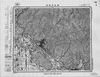
Image from the Map Collections courtesy Stanford University Libraries, licensed under a Creative Commons Attribution-Noncommercial 3.0 Unported License. © Stanford University. 【図幅名】 前橋 【測量時期】 明治40年測図/昭和4年修正/昭和9年要部修正 【発行時期】 【記号】 宇都宮14号 【測量機関】 参謀本部 【備考】 秘 (In 1 layer)
Links: Source / Biblio Ref
|
about 2 years ago | 4 control points | |
|
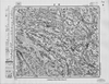
Image from the Map Collections courtesy Stanford University Libraries, licensed under a Creative Commons Attribution-Noncommercial 3.0 Unported License. © Stanford University. 【図幅名】 高萩 【測量時期】 明治42年測図/昭和8年要部修正 【発行時期】 昭和11年1月発行 【記号】 白河8号(共17面) 【測量機関】 大日本帝国陸地測量部 【備考】 (In 1 layer)
Links: Source / Biblio Ref
|
about 2 years ago | 4 control points | |
|
Image from the Map Collections courtesy Stanford University Libraries, licensed under a Creative Commons Attribution-Noncommercial 3.0 Unported License. © Stanford University. 【図幅名】 大子 【測量時期】 明治42年測図/昭和8年要部修正 【発行時期】 昭和11年1月発行 【記号】 白河12号(共17面) 【測量機関】 大日本帝国陸地測量部 【備考】 (In 1 layer)
Links: Source / Biblio Ref
|
about 2 years ago | 4 control points | |
|
Image from the Map Collections courtesy Stanford University Libraries, licensed under a Creative Commons Attribution-Noncommercial 3.0 Unported License. © Stanford University. 【図幅名】 喜連川 【測量時期】 明治42年測図/昭和4年第2回修正 【発行時期】 昭和8年5月発行 【記号】 白河16号(共17面) 【測量機関】 大日本帝国陸地測量部 【備考】 (In 1 layer)
Links: Source / Biblio Ref
|
about 2 years ago | 4 control points | |
|
Image from the Map Collections courtesy Stanford University Libraries, licensed under a Creative Commons Attribution-Noncommercial 3.0 Unported License. © Stanford University. 【図幅名】 矢板 【測量時期】 明治42年測図/昭和4年第2回修正 【発行時期】 昭和21年10月発行 【記号】 日光4号(共16面) 【測量機関】 内務省地理調査所 【備考】 (In 1 layer)
Links: Source / Biblio Ref
|
about 2 years ago | 4 control points | |
|
Image from the Map Collections courtesy Stanford University Libraries, licensed under a Creative Commons Attribution-Noncommercial 3.0 Unported License. © Stanford University. 【図幅名】 日光 【測量時期】 大正1年測図/昭和4年修正/昭和8年鉄道補入、測図の縮図 【発行時期】 昭和22年1月発行 【記号】 日光8号(共16面) 【測量機関】 内務省地理調査所 【備考】 (In 1 layer)
Links: Source / Biblio Ref
|
about 2 years ago | 4 control points | |
|
Image from the Map Collections courtesy Stanford University Libraries, licensed under a Creative Commons Attribution-Noncommercial 3.0 Unported License. © Stanford University. 【図幅名】 【測量時期】 【発行時期】 【記号】 【測量機関】 【備考】 (In 1 layer)
Links: Source / Biblio Ref
|
about 2 years ago | 10 control points | |
|
Image from the Map Collections courtesy Stanford University Libraries, licensed under a Creative Commons Attribution-Noncommercial 3.0 Unported License. © Stanford University. 【図幅名】 常陸大宮 【測量時期】 明治38年測図/大正6年修正/昭和3年鉄道補入 【発行時期】 昭和4年6月発行 【記号】 水戸9号(共12面) 【測量機関】 大日本帝国陸地測量部 【備考】 (In 1 layer)
Links: Source / Biblio Ref
|
about 2 years ago | 4 control points | |
|
Image from the Map Collections courtesy Stanford University Libraries, licensed under a Creative Commons Attribution-Noncommercial 3.0 Unported License. © Stanford University. 【図幅名】 鳥山 【測量時期】 明治39年測図/大正6年修正/大正14年鉄道補入 【発行時期】 【記号】 水戸13号(共12面) 【測量機関】 参謀本部 【備考】 秘 (In 1 layer)
Links: Source / Biblio Ref
|
about 2 years ago | 4 control points | |
|
Image from the Map Collections courtesy Stanford University Libraries, licensed under a Creative Commons Attribution-Noncommercial 3.0 Unported License. © Stanford University. 【図幅名】 宇都宮 【測量時期】 明治40年測図/昭和4年第2回修正/昭和8年鉄道補入、測図の縮図 【発行時期】 昭和22年6月発行 【記号】 宇都宮1号(共16面) 【測量機関】 参謀本部 【備考】 (In 1 layer)
Links: Source / Biblio Ref
|
about 2 years ago | 4 control points | |
|
Image from the Map Collections courtesy Stanford University Libraries, licensed under a Creative Commons Attribution-Noncommercial 3.0 Unported License. © Stanford University. 【図幅名】 鹿沼 【測量時期】 明治40年測図/昭和4年要部修正 【発行時期】 昭和6年8月発行 【記号】 宇都宮5号(共16面) 【測量機関】 大日本帝国陸地測量部 【備考】 (In 1 layer)
Links: Source / Biblio Ref
|
about 2 years ago | 4 control points | |
|
Image from the Map Collections courtesy Stanford University Libraries, licensed under a Creative Commons Attribution-Noncommercial 3.0 Unported License. © Stanford University. 【図幅名】 【測量時期】 【発行時期】 【記号】 【測量機関】 【備考】 (In 1 layer)
Links: Source / Biblio Ref
|
about 2 years ago | 4 control points | |
|
Image from the Map Collections courtesy Stanford University Libraries, licensed under a Creative Commons Attribution-Noncommercial 3.0 Unported License. © Stanford University. 【図幅名】 水戸 【測量時期】 明治36年測図/昭和15年第2回修正、測図の縮図/昭和27年応急修正 【発行時期】 昭和34年6月発行 【記号】 水戸10号(共12面) 【測量機関】 国土地理院 【備考】 応急修正版 (In 1 layer)
Links: Source / Biblio Ref
|
about 2 months ago | 4 control points | |
|
Image from the Map Collections courtesy Stanford University Libraries, licensed under a Creative Commons Attribution-Noncommercial 3.0 Unported License. © Stanford University. 【図幅名】 真岡 【測量時期】 明治38年測図/大正4年修正/大正15年鉄道補入 【発行時期】 【記号】 水戸14号(共12面) 【測量機関】 参謀本部 【備考】 秘 (In 1 layer)
Links: Source / Biblio Ref
|
about 2 years ago | 4 control points | |
|
|
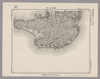
Image from the Map Collections courtesy Stanford University Libraries, licensed under a Creative Commons Attribution-Noncommercial 3.0 Unported License. © Stanford University. 【図幅名】 館山 【測量時期】 明治36年測図/昭和4年修正/昭和19年部分修正 【発行時期】 昭和22年7月発行 【記号】 横須賀3号(共11面) 【測量機関】 地理調査所 【備考】 (In 1 layer)
Links: Source / Biblio Ref
|
about 2 years ago | 4 control points |
 WMS Capabilities URL
 Tiles (Google/OSM scheme)