モザイクが作成できないので、再挑戦! Last modified 3 months ago. Depicts : 1910 Links: Source / Biblio Ref
3 maps (3 maps rectified 100%)
Download KML |
|
|
五万分の一地形圖(北陸)
モザイクが作成できないので、再挑戦! Last modified 3 months ago. Depicts : 1910 Links: Source / Biblio Ref 3 maps (3 maps rectified 100%) Download KML | |

| Map | Title | Year | Last Updated | Status |
|---|---|---|---|---|
|
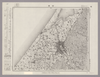
Image from the Map Collections courtesy Stanford University Libraries, licensed under a Creative Commons Attribution-Noncommercial 3.0 Unported License. © Stanford University. 【図幅名】 金沢 【測量時期】 明治42年測図/昭和6年修正 【発行時期】 【記号】 金沢5号 【測量機関】 参謀本部 【備考】 秘 (In 2 layers)
Links: Source / Biblio Ref
|
about 2 years ago | 4 control points | |
|
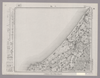
Image from the Map Collections courtesy Stanford University Libraries, licensed under a Creative Commons Attribution-Noncommercial 3.0 Unported License. © Stanford University. 【図幅名】 鶴来 【測量時期】 明治42年測図/昭和5年修正 【発行時期】 昭和8年10月発行 【記号】 金沢6号(共13面) 【測量機関】 大日本帝国陸地測量部 【備考】 (改) (In 2 layers)
Links: Source / Biblio Ref
|
3 months ago | 4 control points | |
|
|
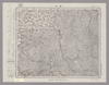
Image from the Map Collections courtesy Stanford University Libraries, licensed under a Creative Commons Attribution-Noncommercial 3.0 Unported License. © Stanford University. 【図幅名】 小松 【測量時期】 明治42年測図/昭和5年修正/昭和8年要部修正 【発行時期】 昭和8年9月発行 【記号】 金沢10号(共13面) 【測量機関】 大日本帝国陸地測量部 【備考】 (In 2 layers)
Links: Source / Biblio Ref
|
2 months ago | 4 control points |
 WMS Capabilities URL
 Tiles (Google/OSM scheme)