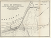
BAHÍA DE CARTAGENA. PLANO PARA ACOMPAÑAR AL INFORME DEL CORONEL P.R WARREN. DEL 16 DE SEPIEMBRE DE 1930. PLANO Nº1. Uploaded by apicon. Depicts: 1930 Last modified over 2 years ago. 29 control points.
| Download KML |
|
|
fmapoteca_2431_fbnc_922
BAHÍA DE CARTAGENA. PLANO PARA ACOMPAÑAR AL INFORME DEL CORONEL P.R WARREN. DEL 16 DE SEPIEMBRE DE 1930. PLANO Nº1. Uploaded by apicon. Depicts: 1930 Last modified over 2 years ago. 29 control points. | Download KML | |
 WMS Capabilities URL
 Tiles (Google/OSM scheme)
 Download control points as CSV