Tags for Kyushu
| Map | Title | Year | Last Updated  |
Status |
|---|---|---|---|---|
|
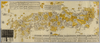
This geotiff map focused on south part of KyushuSatsuma and Osumi.
Type Pocket Map
Obj Height cm 68
Obj Width cm 166
Mounted cover title. Wood block print. In Japanese. Covers Matsumae to Tsushima and Ryukyu. Shows Ezo east from Kanto region. Shows distance of sea routes and main roads and kokudaka of daimyo. Includes legend. East Asian Library call number Ca 11.
Links: Source / Biblio Ref
|
1630 | over 4 years ago | 16 control points |