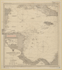
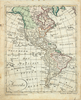
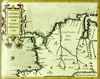
Browse Maps
| map | Title | Year | Last Updated  |
Status |
|---|---|---|---|---|
|
Links: Source / Biblio Ref
|
2021 | about 1 year ago | 4 control points |
|
Links: Source / Biblio Ref
|
2020 | about 1 year ago | 10 control points |
|
Links: Source / Biblio Ref
|
2020 | about 1 year ago | 12 control points |
|
Links: Source / Biblio Ref
|
2020 | about 1 year ago | 4 control points |
|
Links: Source / Biblio Ref
|
2020 | about 1 year ago | 10 control points |
|
Links: Source / Biblio Ref
|
2020 | about 1 year ago | 6 control points |
|
Links: Source / Biblio Ref
|
2020 | about 1 year ago | 7 control points |
|
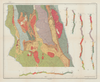
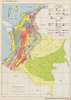
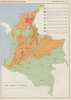
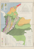
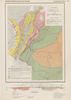
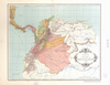
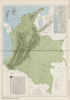
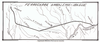
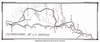
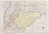
Mapa preliminar de la República de Colombia 1950, Elaborado por el Instituto Geográfico Militar y Catastral.
|
2023 | about 1 year ago | 4 control points |
|
Links: Source / Biblio Ref
|
2021 | about 1 year ago | 14 control points |
|
Links: Source / Biblio Ref
|
2021 | about 1 year ago | 9 control points |
|
|
2023 | about 1 year ago | 3 control points |
|
Links: Source / Biblio Ref
|
2020 | about 1 year ago | 3 control points |
|
Links: Source / Biblio Ref
|
2020 | about 1 year ago | 3 control points |
|
|
2023 | about 1 year ago | 5 control points |
|
Links: Source / Biblio Ref
|
2020 | about 1 year ago | 16 control points |
|
Links: Source / Biblio Ref
|
2021 | about 1 year ago | 37 control points |
|
|
2023 | about 1 year ago | 15 control points |
|
Links: Source / Biblio Ref
|
2020 | about 1 year ago | 5 control points |
|
Links: Source / Biblio Ref
|
2021 | about 1 year ago | 8 control points |
|
Links: Source / Biblio Ref
|
2021 | about 1 year ago | 4 control points |
|
(In 1 layer)
Links: Source / Biblio Ref
|
2020 | about 1 year ago | 5 control points |
|
Links: Source / Biblio Ref
|
2021 | about 1 year ago | 4 control points |

|
|
2023 | about 1 year ago | Unrectified |
|
Links: Source / Biblio Ref
|
2021 | about 1 year ago | 4 control points |
|
(In 1 layer)
Links: Source / Biblio Ref
|
2020 | about 1 year ago | 5 control points |
|
(In 1 layer)
Links: Source / Biblio Ref
|
2020 | about 1 year ago | 4 control points |
|
(In 1 layer)
Links: Source / Biblio Ref
|
2020 | about 1 year ago | 8 control points |
|
(In 1 layer)
Links: Source / Biblio Ref
|
2020 | about 1 year ago | 6 control points |
|
|
2022 | about 1 year ago | 8 control points |
|
shelfmark: Or.75.f.9
License: Public Domain
元禄1 *ケンペル旧蔵。 Xylograph. Ex-Kaempfer. Gardner, #570.
Links: Source / Biblio Ref
|
1688 | about 1 year ago | 3 control points |
|
Image from the Map Collections courtesy Stanford University Libraries. This item is in the public domain. There are no restrictions on use.
【図幅名】 乙女灣【測量時期】 大正5年測圖 【発行時期】昭和11年 【記号】 捨子古丹島十六号 【測量機関】 参謀本部 【その他】千島列島 陸地測量部 (In 1 layer)
Links: Source / Biblio Ref
|
1936 | about 1 year ago | 5 control points |
|
Image from the Map Collections courtesy Stanford University Libraries. This item is in the public domain. There are no restrictions on use.
【図幅名】 黑嶽【測量時期】 大正5年測圖 【発行時期】昭和11年 【記号】 捨子古丹島十五号 【測量機関】 参謀本部 【その他】千島列島 陸地測量部 (In 1 layer)
Links: Source / Biblio Ref
|
1936 | about 1 year ago | 4 control points |
|
Image from the Map Collections courtesy Stanford University Libraries. This item is in the public domain. There are no restrictions on use.
【図幅名】 越渇麿嶋【測量時期】 大正5年測圖 【発行時期】昭和11年 【記号】 知林古丹島三号 【測量機関】 参謀本部 【その他】千島列島 陸地測量部 (In 1 layer)
Links: Source / Biblio Ref
|
1936 | about 1 year ago | 4 control points |
|
Image from the Map Collections courtesy Stanford University Libraries. This item is in the public domain. There are no restrictions on use.
【図幅名】 後鏃岳【測量時期】 大正3年測圖 【発行時期】大正13年 【記号】 幌筵島十五号 【測量機関】 参謀本部 【その他】千島列島 陸地測量部 (In 1 layer)
Links: Source / Biblio Ref
|
1924 | about 1 year ago | 4 control points |
|
Image from the Map Collections courtesy Stanford University Libraries. This item is in the public domain. There are no restrictions on use.
【図幅名】 寶珠山【測量時期】 大正4年測圖 【発行時期】昭和11年 【記号】 捨子古丹島一号 【測量機関】 参謀本部 【その他】千島列島 陸地測量部 (In 1 layer)
Links: Source / Biblio Ref
|
1936 | about 1 year ago | 4 control points |
|
Image from the Map Collections courtesy Stanford University Libraries. This item is in the public domain. There are no restrictions on use.
【図幅名】 雷公計島【測量時期】 大正6年測圖 【発行時期】昭和11年 【記号】 松輪島十五号 【測量機関】 参謀本部 【その他】千島列島 陸地測量部 (In 1 layer)
Links: Source / Biblio Ref
|
1936 | about 1 year ago | 4 control points |
|
Image from the Map Collections courtesy Stanford University Libraries. This item is in the public domain. There are no restrictions on use.
【図幅名】 松輪島 【測量時期】 大正6年測圖 【発行時期】昭和11年 【記号】 松輪島十七号 【測量機関】 参謀本部 【その他】千島列島 陸地測量部 (In 1 layer)
Links: Source / Biblio Ref
|
1936 | about 1 year ago | 5 control points |
|
Image from the Map Collections courtesy Stanford University Libraries. This item is in the public domain. There are no restrictions on use.
【図幅名】 羅處和島【測量時期】 大正6年測圖 【発行時期】昭和11年 【記号】 羅處和島二号 【測量機関】 参謀本部 【その他】千島列島 陸地測量部 (In 1 layer)
Links: Source / Biblio Ref
|
1936 | about 1 year ago | 4 control points |
|
Image from the Map Collections courtesy Stanford University Libraries. This item is in the public domain. There are no restrictions on use.
【図幅名】 計吐夷島 【測量時期】 大正6年測圖 【発行時期】昭和11年 【記号】 羅処和島八号、十二号、新知島一号【測量機関】 参謀本部 【その他】千島列島 陸地測量部 (In 1 layer)
Links: Source / Biblio Ref
|
1936 | about 1 year ago | 4 control points |
|
Image from the Map Collections courtesy Stanford University Libraries. This item is in the public domain. There are no restrictions on use.
【図幅名】 新知嶽 【測量時期】 大正5年測圖 【発行時期】昭和11年 【記号】 新知島十二号 【測量機関】 参謀本部 【その他】千島列島 陸地測量部 (In 1 layer)
Links: Source / Biblio Ref
|
1936 | about 1 year ago | 4 control points |
|
Image from the Map Collections courtesy Stanford University Libraries. This item is in the public domain. There are no restrictions on use.
【図幅名】 新知灣 【測量時期】 大正5年測圖 【発行時期】昭和11年 【記号】 新知島十一号 【測量機関】 参謀本部【その他】千島列島 陸地測量部 (In 1 layer)
Links: Source / Biblio Ref
|
1936 | about 1 year ago | 4 control points |
|
Image from the Map Collections courtesy Stanford University Libraries. This item is in the public domain. There are no restrictions on use.
【図幅名】 末廣嶽 【測量時期】 大正5年測圖 【発行時期】昭和11年 【記号】 新知島七号 【測量機関】 参謀本部 【その他】千島列島 陸地測量部 (In 1 layer)
Links: Source / Biblio Ref
|
1936 | about 1 year ago | 4 control points |
|
Image from the Map Collections courtesy Stanford University Libraries. This item is in the public domain. There are no restrictions on use.
【図幅名】 宇志知島【測量時期】 大正6年測圖 【発行時期】昭和11年 【記号】 羅処和島三号 【測量機関】 参謀本部 【その他】千島列島 陸地測量部 (In 1 layer)
Links: Source / Biblio Ref
|
1936 | about 1 year ago | 4 control points |
|
Image from the Map Collections courtesy Stanford University Libraries. This item is in the public domain. There are no restrictions on use.
【図幅名】 武魯頓嶋【測量時期】 大正5年測圖 【発行時期】昭和11年 【記号】 千島列島四十七号、知理保以嶋一号西北部 【測量機関】 参謀本部 【その他】千島列島 陸地測量部 (In 1 layer)
Links: Source / Biblio Ref
|
1936 | about 1 year ago | 5 control points |
|
Image from the Map Collections courtesy Stanford University Libraries. This item is in the public domain. There are no restrictions on use.
【図幅名】 知理保以北嶋【測量時期】 大正5年測圖 【発行時期】昭和11年 【記号】 知理保以島一号 【測量機関】 参謀本部 【その他】千島列島 陸地測量部 (In 1 layer)
Links: Source / Biblio Ref
|
1936 | about 1 year ago | 4 control points |
|
Image from the Map Collections courtesy Stanford University Libraries. This item is in the public domain. There are no restrictions on use.
【図幅名】 知理保以南嶋【測量時期】 大正5年測圖 【発行時期】昭和11年 【記号】 千島列島四十六号 【測量機関】 参謀本部 【その他】千島列島 陸地測量部 (In 1 layer)
Links: Source / Biblio Ref
|
1936 | about 1 year ago | 4 control points |
|
Image from the Map Collections courtesy Stanford University Libraries. This item is in the public domain. There are no restrictions on use.
【図幅名】 白妙山【測量時期】 大正4年測圖 【発行時期】昭和11年 【記号】 千島列島五十八号 【測量機関】 参謀本部 【その他】千島列島 陸地測量部 (In 1 layer)
Links: Source / Biblio Ref
|
1936 | about 1 year ago | 4 control points |
|
Image from the Map Collections courtesy Stanford University Libraries. This item is in the public domain. There are no restrictions on use.
【図幅名】 伽藍崎【測量時期】 大正4年測圖 【発行時期】昭和11年 【記号】 千島列島五十六号 【測量機関】 参謀本部 【その他】千島列島 陸地測量部 (In 1 layer)
Links: Source / Biblio Ref
|
1936 | about 1 year ago | 4 control points |
|
Image from the Map Collections courtesy Stanford University Libraries. This item is in the public domain. There are no restrictions on use.
【図幅名】 ピリカモヘ崎【測量時期】 大正4年測圖 【発行時期】昭和11年 【記号】 千島列島五十七号 【測量機関】 参謀本部 【その他】千島列島 陸地測量部 (In 1 layer)
Links: Source / Biblio Ref
|
1936 | about 1 year ago | 4 control points |
|
Image from the Map Collections courtesy Stanford University Libraries. This item is in the public domain. There are no restrictions on use.
【図幅名】 床丹【測量時期】 大正4年測圖 【発行時期】昭和11年 【記号】 千島列島五十五号 【測量機関】 参謀本部 【その他】千島列島 陸地測量部 (In 1 layer)
Links: Source / Biblio Ref
|
1936 | about 1 year ago | 4 control points |