地図を見る
| 地図 | タイトル | 年 | 前回の更新 | ステータス  |
|---|---|---|---|---|
|
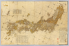
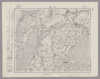
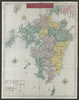
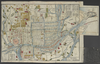
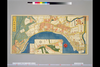
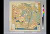
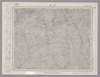
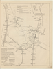
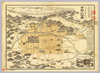
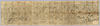
【Courtesy of the C. V. Starr East Asian Library University of California, Berkeley】 1 map : hand col. ; on sheet 83 x 126 cm., folded in cover 21 x 17 cm. Wood block print. In Japanese. Title from: Nihon chizushi / Akioka Takejiro. p. 147. Covers Matsumae to Tsushima and Ryukyu and Hachijojima. Preface by Shibano Ritsuzan in 1775. Oriented with north to the upper right. Shows longitude and latitude. Includes legend, explanation of tides, Ogasawara and Izu Shichito and text by the author. East Asian Library call number Ca-12.
リンク: 出所・参照情報
|
1779 | 3年以上 前 | 5個の基準点 |
|
|
2020 | 3年以上 前 | 5個の基準点 |
|
|
2023 | 11ヶ月 前 | 8個の基準点 |
|
リンク: 出所・参照情報
|
2020 | 1年以上 前 | 4個の基準点 |
|
Image from the Map Collections courtesy Stanford University Libraries, licensed under a Creative Commons Attribution-Noncommercial 3.0 Unported License. © Stanford University. 【図幅名】 三条 【測量時期】 明治44年測図/昭和6年修正 【発行時期】 【記号】 長岡3号(共11面) 【測量機関】 参謀本部 【備考】 秘
リンク: 出所・参照情報
|
約2年 前 | 4個の基準点 | |
|
shelfmark: Or.75.f.131
License: Public Domain
貞享年間刊 *ケンペル旧蔵。無刊記。 Xylograph. Ex-Kaempfer. Gardner #566.
リンク: 出所・参照情報
|
約3年 前 | 24個の基準点 | |
|
shelfmark: Maps 38.b.174
License: Public Domain
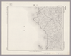
明治初期刊 *銅板。多色刷り。無刊記。北海道・樺太・千島列島・琉球諸島等を含む。英字書き入れ。赤色の線で本州・九州の旅のルートを示す。 Copperplate.
リンク: 出所・参照情報
|
約3年 前 | 27個の基準点 | |
|
【Courtesy of the C. V. Starr East Asian Library University of California, Berkeley】 Colored historical map. Sugoroku game map. Cover title: Rekishi chiri oyo chizu sugoroku. Includes illustrations and insets including illustrations showing relative heights of mountains and lengths of rivers. Folded in paper cover 26 x 21 cm. East Asian Library call number: A992C116 Sugoroku.
リンク: 出所・参照情報
|
1894 | 3年以上 前 | 4個の基準点 |
|
shelfmark: Maps 38.b.161
License: Public Domain
明治10 *銅版。多色刷り。 Copperplate
リンク: 出所・参照情報
|
1877 | 3年以上 前 | 8個の基準点 |
|
shelfmark: Or.75.f.16
License: Public Domain
貞享3 *ケンペル自筆書入あり。 Xylograph. Ex-Kaempfer. Gardner #564; Kyotozu somokuroku, p.13, #26.
リンク: 出所・参照情報
|
1686 | 3年以上 前 | 4個の基準点 |
|
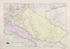
Plan de Fès El Bali levé par le Lieutenant Orthlieb du 4e régiment de Tirailleurs
Octobre 1912, Avril 1913
|
1913 | 約3年 前 | 5個の基準点 |
|
shelfmark: Or.75.f.9
License: Public Domain
元禄1 *ケンペル旧蔵。 Xylograph. Ex-Kaempfer. Gardner, #570.
リンク: 出所・参照情報
|
1688 | 約1年 前 | 3個の基準点 |
|
shelfmark: Maps 38.b.168
License: Public Domain
天保13 *多色刷り。刊記「浪花書林/石川屋和助」。英字書き入れ多し。 Xylograph.
リンク: 出所・参照情報
|
1842 | 3年弱 前 | 3個の基準点 |
|
リンク: 出所・参照情報
|
2020 | 約1年 前 | 11個の基準点 |
|
Image from the Map Collections courtesy Stanford University Libraries, licensed under a Creative Commons Attribution-Noncommercial 3.0 Unported License. © Stanford University. 【図幅名】 元木 【測量時期】 大正5年測図 【発行時期】 大正7年4月発行 【記号】 盛岡9号(共18面) 【測量機関】 大日本帝国陸地測量部 【備考】
リンク: 出所・参照情報
|
約2年 前 | 4個の基準点 | |
|
リンク: 出所・参照情報
|
2020 | 約1年 前 | 4個の基準点 |
|
国立国会図書館デジタルコレクション インターネット公開(保護期間満了) ( 3枚のレイヤー)
リンク: 出所・参照情報
|
1850 | 3年以上 前 | 29個の基準点 |
|
リンク: 出所・参照情報
|
2020 | 約1年 前 | 3個の基準点 |
|
shelfmark: Maps 38.b.175
License: Public Domain
明治15 *銅板。多色刷り。英字書き入れ。赤色の線で朝鮮の旅のルートを示す。 Copperplate.
リンク: 出所・参照情報
|
1882 | 約3年 前 | 8個の基準点 |

|
リンク: 出所・参照情報
|
2020 | 約1年 前 | 4個の基準点 |

|
【Courtesy of the C. V. Starr East Asian Library University of California, Berkeley】 1 atlas 44, 4 leaves : 20 maps ; 13 cm. Mounted cover title. Copperplate print. In Japanese. Shows views of tourist attractions. Includes text. Alternate Title Dai Nihon dochu annai. East Asian Library call number: J45 SPEC-Map.
リンク: 出所・参照情報
|
1887 | 約2年 前 | 14個の基準点 |
|
リンク: 出所・参照情報
|
2020 | 約1年 前 | 5個の基準点 |
|
国立国会図書館デジタルコレクション インターネット公開(保護期間満了) ( 2枚のレイヤー)
リンク: 出所・参照情報
|
1853 | 3年以上 前 | 33個の基準点 |
|
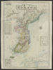
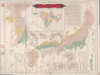
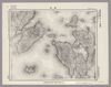
【Courtesy of the C. V. Starr East Asian Library University of California, Berkeley】 Description 1 map: hand col.; 68 x 166 cm., folded to 24 x 18 cm. Mounted cover title. Wood block print. In Japanese. Covers Matsumae to Tsushima and Ryukyu. Shows Ezo east from Kanto region. Shows distance of sea routes and main roads and kokudaka of daimyo. Includes legend. East Asian Library call number Ca 11.
リンク: 出所・参照情報
|
1630 | 3年以上 前 | 5個の基準点 |
|
国立国会図書館デジタルコレクション インターネット公開(保護期間満了) ( 3枚のレイヤー)
リンク: 出所・参照情報
|
1850 | 3年以上 前 | 38個の基準点 |
|
Image from the Map Collections courtesy Stanford University Libraries, licensed under a Creative Commons Attribution-Noncommercial 3.0 Unported License. © Stanford University. 【図幅名】 小千谷 【測量時期】 明治44年測図/昭和4年鉄道補入 【発行時期】 昭和6年6月発行 【記号】 高田1号(共15面) 【測量機関】 大日本帝国陸地測量部 【備考】
リンク: 出所・参照情報
|
約2年 前 | 4個の基準点 | |
|
Image from the Map Collections courtesy Stanford University Libraries, licensed under a Creative Commons Attribution-Noncommercial 3.0 Unported License. © Stanford University. 【図幅名】 馬路 【測量時期】 明治40年測圖/昭和8年修正測圖 【発行時期】 【記号】 剣山十五号 【測量機関】 参謀本部 【備考】 祕
リンク: 出所・参照情報
|
約2年 前 | 4個の基準点 | |
|
Image from the Map Collections courtesy Stanford University Libraries, licensed under a Creative Commons Attribution-Noncommercial 3.0 Unported License. © Stanford University. 【図幅名】 本山 【測量時期】 明治39年測図/昭和8年修正 【発行時期】 昭和11年6月発行 【記号】 高知6号(共16面) 【測量機関】 大日本帝国陸地測量部 【備考】
リンク: 出所・参照情報
|
約2年 前 | 4個の基準点 | |
|
Image from the Map Collections courtesy Stanford University Libraries, licensed under a Creative Commons Attribution-Noncommercial 3.0 Unported License. © Stanford University. 【図幅名】 富岡 【測量時期】 明治40年測図/昭和4年修正/昭和9年要部修正 【発行時期】 昭和15年8月発行 【記号】 長野3号(共16面) 【測量機関】 大日本帝国陸地測量部 【備考】
リンク: 出所・参照情報
|
約2年 前 | 4個の基準点 | |
|
Image from the Map Collections courtesy Stanford University Libraries, licensed under a Creative Commons Attribution-Noncommercial 3.0 Unported License. © Stanford University. 【図幅名】 見島 【測量時期】 明治32年測図/昭和11年修正 【発行時期】 昭和21年8月発行 【記号】 見島16号(共3面) 【測量機関】 内務省地理調査所 【備考】
リンク: 出所・参照情報
|
約2年 前 | 4個の基準点 | |
|
|
2023 | 11ヶ月 前 | 7個の基準点 |
|
Image from the Map Collections courtesy Stanford University Libraries, licensed under a Creative Commons Attribution-Noncommercial 3.0 Unported License. © Stanford University. 【図幅名】 犬飼 【測量時期】 明治35年測図/昭和7年要部修正/昭和23年資料修正 【発行時期】 昭和23年11月発行 【記号】 大分6号(共16面) 【測量機関】 地理調査所 【備考】
リンク: 出所・参照情報
|
4年弱 前 | 4個の基準点 | |
|
Image from the Map Collections courtesy Stanford University Libraries, licensed under a Creative Commons Attribution-Noncommercial 3.0 Unported License. © Stanford University. 【図幅名】 勝本 【測量時期】 大正12年測図の縮図/昭和10年修正、測図の縮図 【発行時期】 昭和21年11月発行 【記号】 唐津5号(共8面) 【測量機関】 地理調査所 【備考】
リンク: 出所・参照情報
|
4年弱 前 | 4個の基準点 | |
|
Image from the Map Collections courtesy Stanford University Libraries, licensed under a Creative Commons Attribution-Noncommercial 3.0 Unported License. © Stanford University. 【図幅名】 郷ノ浦 【測量時期】 大正12年測図の縮図/昭和10年修正、測図の縮図 【発行時期】 昭和21年11月発行 【記号】 唐津6号(共8面) 【測量機関】 地理調査所 【備考】
リンク: 出所・参照情報
|
4年弱 前 | 4個の基準点 | |
|
【Courtesy of the C. V. Starr East Asian Library University of California, Berkeley】 In Japanese. Oriented with north to the left. Relief shown pictorially. Includes distance chart, a fare table and a view of a temple. Folded to 27 x 13 cm. Col. East Asian Library call number: F131.
リンク: 出所・参照情報
|
1902 | 3年以上 前 | 18個の基準点 |
|
Image from the Map Collections courtesy Stanford University Libraries, licensed under a Creative Commons Attribution-Noncommercial 3.0 Unported License. © Stanford University. 【図幅名】 観音寺 【測量時期】 明治39年測図/昭和3年修正 【発行時期】 昭和7年5月発行 【記号】 岡山及丸亀8号(共16面) 【測量機関】 大日本帝国陸地測量部 【備考】
リンク: 出所・参照情報
|
約2年 前 | 4個の基準点 | |
|
Image from the Map Collections courtesy Stanford University Libraries, licensed under a Creative Commons Attribution-Noncommercial 3.0 Unported License. © Stanford University. 【図幅名】 脇町 【測量時期】 明治29年測図/昭和9年第2回修正、測図の縮図 【発行時期】 【記号】 徳島16号(共14面) 【測量機関】 参謀本部 【備考】 秘
リンク: 出所・参照情報
|
約2年 前 | 4個の基準点 | |
|
Image from the Map Collections courtesy Stanford University Libraries. This item is in the public domain. There are no restrictions on use.
【図幅名】 兜山【測量時期】 大正4年測圖 【発行時期】昭和11年 【記号】 捨子古丹島五号 【測量機関】 参謀本部 【その他】千島列島 陸地測量部
リンク: 出所・参照情報
|
2023 | 約1年 前 | 4個の基準点 |
|
【Courtesy of the C. V. Starr East Asian Library University of California, Berkeley】 1 map ; 34 x 150 cm., folded in cover 19 x 10 cm. Mounted cover title. Copperplate print. In Japanese. Relief shown pictorially. Includes legend. Shows distances of roads and sea routes. East Asian Library call number: Cb75.
リンク: 出所・参照情報
|
1881 | 約3年 前 | 4個の基準点 |
|
【Courtesy of the C. V. Starr East Asian Library University of California, Berkeley】 Mounted cover title. Copperplate print. In Japanese. Relief shown by hachures. Includes distance chart, 14 insets and legend. Col. map folded in cover 15 x 8 cm. East Asian Library call number Cb67.
リンク: 出所・参照情報
|
1879 | 約3年 前 | 5個の基準点 |
|
Image from the Map Collections courtesy Stanford University Libraries, licensed under a Creative Commons Attribution-Noncommercial 3.0 Unported License. © Stanford University. 【図幅名】 志度 【測量時期】 明治29年測図/明治30年測図の縮図/昭和3年修正、測図の縮図/昭和7年鉄道補入、測図の縮図 【発行時期】 【記号】 徳島15号(共14面) 【測量機関】 参謀本部 【備考】 秘
リンク: 出所・参照情報
|
約2年 前 | 4個の基準点 | |
|
Image from the Map Collections courtesy Stanford University Libraries, licensed under a Creative Commons Attribution-Noncommercial 3.0 Unported License. © Stanford University. 【図幅名】 海南 【測量時期】 明治43年測図の縮図/明治44年測図/昭和9年第2回修正、測図の縮図 【発行時期】 昭和16年7月発行 【記号】 由良要塞近傍5号(共10面) 【測量機関】 参謀本部 【備考】 和歌山16号(共16面) 軍事極秘
リンク: 出所・参照情報
|
約2年 前 | 4個の基準点 | |
|
Image from the Map Collections courtesy Stanford University Libraries, licensed under a Creative Commons Attribution-Noncommercial 3.0 Unported License. © Stanford University. 【図幅名】 早田 【測量時期】 明治44年測図/昭和8年要部修正 【発行時期】 昭和11年5月発行 【記号】 木本9号(共3面) 【測量機関】 大日本帝国陸地測量部 【備考】
リンク: 出所・参照情報
|
約2年 前 | 4個の基準点 | |
|
Image from the Map Collections courtesy Stanford University Libraries, licensed under a Creative Commons Attribution-Noncommercial 3.0 Unported License. © Stanford University. 【図幅名】 小串 【測量時期】 明治32年測図/大正11年測図の縮図/昭和11年第2回修正、測図の縮図/昭和24年応急修正 【発行時期】 昭和25年11月発行 【記号】 小串3号(共4面) 【測量機関】 地理調査所 【備考】 応急修正版
リンク: 出所・参照情報
|
約2年 前 | 4個の基準点 | |
|
Image from the Map Collections courtesy Stanford University Libraries, licensed under a Creative Commons Attribution-Noncommercial 3.0 Unported License. © Stanford University. 【図幅名】 厳島 【測量時期】 明治27年測図/明治32年測図の縮図/大正14年修正、測図の縮図/昭和7年鉄道補入、測図の縮図 【発行時期】 昭和21年8月発行 【記号】 広島11号(共16面) 【測量機関】 内務省地理調査所 【備考】
リンク: 出所・参照情報
|
約2年 前 | 4個の基準点 | |
|
Image from the Map Collections courtesy Stanford University Libraries, licensed under a Creative Commons Attribution-Noncommercial 3.0 Unported License. © Stanford University. 【図幅名】 小茂田 【測量時期】 大正1年測図の縮図/昭和10年第2回修正、測図の縮図 【発行時期】 昭和22年1月発行 【記号】 厳原15号(共7面) 【測量機関】 地理調査所 【備考】
リンク: 出所・参照情報
|
4年弱 前 | 4個の基準点 | |
|
|
2022 | 1年以上 前 | 6個の基準点 |
|
リンク: 出所・参照情報
|
2020 | 3年以上 前 | 8個の基準点 |
|
|
2022 | 1年以上 前 | 5個の基準点 |
|
Image from the Map Collections courtesy Stanford University Libraries, licensed under a Creative Commons Attribution-Noncommercial 3.0 Unported License. © Stanford University. 【図幅名】 寄島 【測量時期】 明治34年測図/明治35年測図/大正14年測図/昭和3年第2回修正 【発行時期】 昭和5年8月発行 【記号】 岡山及丸亀6号(共16面) 【測量機関】 大日本帝国陸地測量部 【備考】
リンク: 出所・参照情報
|
約2年 前 | 4個の基準点 |