地図を見る
| 地図 | タイトル | 年 | 前回の更新 | ステータス  |
|---|---|---|---|---|
|
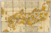
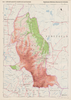
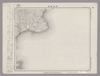
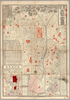
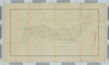
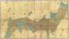
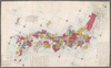
【Courtesy of the C. V. Starr East Asian Library University of California, Berkeley】 Description 1 map: hand col.; 76 x 119 cm., folded in cover 26 x 16 cm. Mounted cover title. Wood block print. In Japanese. Covers Matsumae to Tsushima, and Hachijojima. Shows distance of sea routes and kokudaka by province. Includes legend. East Asian Library call number Ca 22.
リンク: 出所・参照情報
|
1700 | 3年以上 前 | 5個の基準点 |
|
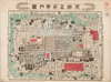
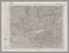
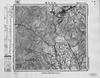
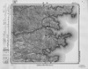
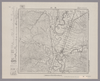
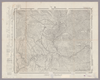
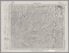
【Courtesy of the C. V. Starr East Asian Library University of California, Berkeley】 Title on envelope: Kyoto meisai chizu. Wood block print. In Japanese. Oriented with north to the left. Relief shown pictorially. Includes distance chart and legend.
リンク: 出所・参照情報
|
1895 | 約3年 前 | 4個の基準点 |
|
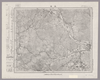
この地図の作成に当たっては、国土地理院長の承認を得て、同院発行の20万分の1地勢図及び5万分の1地形図を使用した。(承認番号 平30情使、 第1148号)
リンク: 出所・参照情報
|
1948 | 約5年 前 | 4個の基準点 |
|
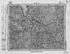
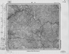
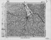
Image from the Map Collections courtesy Stanford University Libraries, licensed under a Creative Commons Attribution-Noncommercial 3.0 Unported License. © Stanford University. 【図幅名】 坂城 【測量時期】 明治43年測図/昭和12年第2回修正 【発行時期】 【記号】 長野14号 【測量機関】 参謀本部 【備考】 秘
リンク: 出所・参照情報
|
2年弱 前 | 4個の基準点 | |
|
リンク: 出所・参照情報
|
2020 | 2年以上 前 | 4個の基準点 |
|
この地図の作成に当たっては、国土地理院長の承認を得て、同院発行の20万分の1地勢図及び5万分の1地形図を使用した。(承認番号 平30情使、 第1148号)
リンク: 出所・参照情報
|
1947 | 約5年 前 | 4個の基準点 |
|
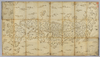
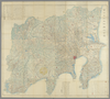
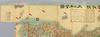
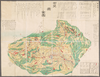
【Courtesy of the C. V. Starr East Asian Library University of California, Berkeley】 1 map : hand col. ; 85 x 140 cm., folded to 29 x 17 cm. Mounted cover title. Wood block print. In Japanese. Covers Matsumae to Tsushima, Yakushima, and Hachijojima. Oriented with north to the upper right. Preface by Shibano Ritsuzan. Engraved by Inoue Jihe. Shows longitude and latitude. Includes legend, distance chart of sea routes, and explanation of Kuroshio and tides. East Asian Library call number Ca 17.1.
リンク: 出所・参照情報
|
1811 | 3年以上 前 | 5個の基準点 |
|
この地図の作成に当たっては、国土地理院長の承認を得て、同院発行の20万分の1地勢図及び5万分の1地形図を使用した。(承認番号 平30情使、 第1148号)
リンク: 出所・参照情報
|
1947 | 約5年 前 | 4個の基準点 |
|
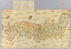
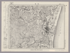
【Courtesy of the C. V. Starr East Asian Library University of California, Berkeley】 1 map : hand col. ; 60 x 107 cm., folded in cover 21 x 15 cm. Notes Mounted cover title. Wood block print. In Japanese. Covers Matsumae to Tsushima, Tojima, Ryukyu, and Hachijojima. Shows distance of sea routes. Includes legend. East Asian Library call number Ca 19.
リンク: 出所・参照情報
|
1730 | 3年以上 前 | 5個の基準点 |
|
Image from the Map Collections courtesy Stanford University Libraries, licensed under a Creative Commons Attribution-Noncommercial 3.0 Unported License. © Stanford University. 【図幅名】 剣山 【測量時期】 明治40年測圖/昭和8年修正測圖 【発行時期】 【記号】 剣山十三号 【測量機関】 参謀本部 【備考】 祕
リンク: 出所・参照情報
|
2年弱 前 | 4個の基準点 | |
|
【Courtesy of the C. V. Starr East Asian Library University of California, Berkeley】 1 map : hand col. ; 61 x 109 cm., folded to 17 x 15 cm., in envelope 31 x 21 cm. Wood block print. In Japanese. Covers Matsumae to Tsushima, Iojima, Ryukyu, and Hachijojima. Title added by hand. Shows distance of sea routes. Includes legend. East Asian Library call number Ca_21.
リンク: 出所・参照情報
|
1730 | 3年以上 前 | 5個の基準点 |
|
Image from the Map Collections courtesy Stanford University Libraries, licensed under a Creative Commons Attribution-Noncommercial 3.0 Unported License. © Stanford University. 【図幅名】 母島北部 【測量時期】 明治44年測圖/昭和10年修正測圖 【発行時期】 【記号】 父島十六号 【測量機関】 参謀本部 【備考】 軍事極祕(戦地ニ在りテハ軍事祕密トス)
リンク: 出所・参照情報
|
2年弱 前 | 4個の基準点 | |
|
Image from the Map Collections courtesy Stanford University Libraries, licensed under a Creative Commons Attribution-Noncommercial 3.0 Unported License. © Stanford University. 【図幅名】 能登飯田 【測量時期】 明治43年測図/昭和9年修正 【発行時期】 昭和12年2月発行 【記号】 珠洲岬12号(共4面) 【測量機関】 大日本帝国陸地測量部 【備考】
リンク: 出所・参照情報
|
2年弱 前 | 4個の基準点 | |
|
この地図の作成に当たっては、国土地理院長の承認を得て、同院発行の20万分の1地勢図及び5万分の1地形図を使用した。(承認番号 平30情使、 第1148号)
リンク: 出所・参照情報
|
1946 | 約5年 前 | 4個の基準点 |
|
shelfmark: Maps 38.c.218
License: Public Domain
天保14 *無刊記。外題「(富士見十三州)輿地之全図」。江戸湾に「御台場」あり。凡例末を入れ木して「故名焉」と改む。左下欄外に「木邨嘉平刻」とあり。 Xylograph.
リンク: 出所・参照情報
|
1843 | 3年以上 前 | 32個の基準点 |
|
Image from the Map Collections courtesy Stanford University Libraries, licensed under a Creative Commons Attribution-Noncommercial 3.0 Unported License. © Stanford University. 【図幅名】 福渡 【測量時期】 明治30年測圖/昭和7年要部修正測圖 【発行時期】 【記号】 高梁三号 【測量機関】 参謀本部 【備考】 祕
リンク: 出所・参照情報
|
19日 前 | 4個の基準点 | |
|
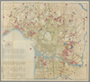
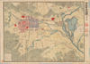
【Courtesy of the C. V. Starr East Asian Library University of California, Berkeley】 Japanese date Meiji 40 1907. In color. Folded. In Japanese. Relief shown by hachures. 4 insets: Rakugai meishōzu; Heian kozu; Fushimi-chō shigaizu; Ōtsu shigaizu. Includes distance chart, index, list of addresses and legend. Shows views of tourist attractions. Includes text of tourist attractions on verso.
リンク: 出所・参照情報
|
1907 | 3年以上 前 | 4個の基準点 |
|
この地図の作成に当たっては、国土地理院長の承認を得て、同院発行の20万分の1地勢図及び5万分の1地形図を使用した。(承認番号 平30情使、 第1148号)
リンク: 出所・参照情報
|
1947 | 約5年 前 | 4個の基準点 |
|
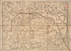
【Courtesy of the C. V. Starr East Asian Library University of California, Berkeley】 Japanese date Meiji 28 1895. In color. Folded. Title on envelope: Kaisei jissoku Dai Nihon shinchizu : fu shinryōchi Taiwan chizu. In Japanese. Oriented with north to the upper right. Relief shown by hachures. Includes 6 insets: Manshū Shinkoku.--Hokkaidō.--Shinryōchi Taiwan zenzu ... et al.. Includes list of district names, charts of mountains and rivers, and legend. Shows sea routes with distances.
リンク: 出所・参照情報
|
1895 | 3年以上 前 | 4個の基準点 |
|
この地図の作成に当たっては、国土地理院長の承認を得て、同院発行の20万分の1地勢図及び5万分の1地形図を使用した。(承認番号 平30情使、 第1148号)
リンク: 出所・参照情報
|
1946 | 約5年 前 | 4個の基準点 |
|
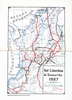
明治の国道図
|
1885 | 約2年 前 | 11個の基準点 |
|
この地図の作成に当たっては、国土地理院長の承認を得て、同院発行の20万分の1地勢図及び5万分の1地形図を使用した。(承認番号 平30情使、 第1148号)
リンク: 出所・参照情報
|
1947 | 約5年 前 | 4個の基準点 |
|
【Courtesy of the C. V. Starr East Asian Library University of California, Berkeley】 Mounted cover title. Copperplate print. In Japanese. Orientation varies. Relief shown pictorially. Includes 2 insets, list of capitals and legend. Hand tinted in color. Folded to 19 x 8 cm.
リンク: 出所・参照情報
|
1888 | 3年以上 前 | 5個の基準点 |
|
この地図の作成に当たっては、国土地理院長の承認を得て、同院発行の20万分の1地勢図及び5万分の1地形図を使用した。(承認番号 平30情使、 第1148号)
リンク: 出所・参照情報
|
1946 | 約5年 前 | 4個の基準点 |
|
この地図の作成に当たっては、国土地理院長の承認を得て、同院発行の20万分の1地勢図及び5万分の1地形図を使用した。(承認番号 平30情使、 第1148号)
リンク: 出所・参照情報
|
1947 | 約5年 前 | 4個の基準点 |
|
|
2022 | 2年弱 前 | 4個の基準点 |
|
リンク: 出所・参照情報
|
2021 | 2年以上 前 | 9個の基準点 |
|
リンク: 出所・参照情報
|
2020 | 1年以上 前 | 14個の基準点 |
|
【Courtesy of the C. V. Starr East Asian Library University of California, Berkeley】 1 map : col. ; 101 x 183 cm., folded to 27 x 19 cm. Title added by hand. Wood block print. In Japanese. Oriented with north to the upper right. Covers Matsumae to Okinoerabujima, Tsushima and Ogasawara. Shows the distance of sea routes and Kuroshio. Includes legend. Alternate Title: Dai Nihon kokugun yochi rotei zenzu. East Asian Library call number Ca 34.
リンク: 出所・参照情報
|
1852 | 3年以上 前 | 5個の基準点 |
|
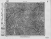
Image from the Map Collections courtesy Stanford University Libraries, licensed under a Creative Commons Attribution-Noncommercial 3.0 Unported License. © Stanford University. 【図幅名】 滝川 【測量時期】 大正5年測図/昭和10年鉄道補入 【発行時期】 昭和11年8月発行 【記号】 留萌3号(共11面) 【測量機関】 大日本帝国陸地測量部 【備考】 ( 1枚のレイヤー)
リンク: 出所・参照情報
|
2年弱 前 | 4個の基準点 | |
|
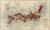
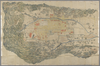
【Courtesy of the C. V. Starr East Asian Library University of California, Berkeley】 1 map : col. ; on sheet 87 x 246 cm., folded to 25 x 18 cm. Wood block print. In Japanese. Oriented with north to the upper right. Relief shown pictorially. Includes 1 ancillary map, list of prefecture, and legend. Extension pasted on the bottom of map. East Asian Library call number Cb 2.
リンク: 出所・参照情報
|
1874 | 3年以上 前 | 4個の基準点 |
|
Image from the Map Collections courtesy Stanford University Libraries, licensed under a Creative Commons Attribution-Noncommercial 3.0 Unported License. © Stanford University. 【図幅名】 宮崎 【測量時期】 明治35年測圖/昭和7年修正測圖/昭和10年部分修正測圖 【発行時期】 【記号】 宮崎九号 【測量機関】 参謀本部 【備考】 祕
リンク: 出所・参照情報
|
4年弱 前 | 4個の基準点 | |
|
shelfmark: 16084.c.29
License: Public Domain
天保14 *多色刷り。附「江戸年中行事」。(刊記)元禄九年丙子旧板/文政五年壬午年補改/天保十四年癸卯再板/御書物師、出雲寺万次郎/書林、岡田屋嘉七/ (襴外)万延元年庚申改正。修訂の箇所あり。 Xylograph. Kawase p. 208.
リンク: 出所・参照情報
|
1843 | 3年以上 前 | 3個の基準点 |
|
Image from the Map Collections courtesy Stanford University Libraries, licensed under a Creative Commons Attribution-Noncommercial 3.0 Unported License. © Stanford University. 【図幅名】 【測量時期】 【発行時期】 【記号】 【測量機関】 【備考】
リンク: 出所・参照情報
|
5年以上 前 | 4個の基準点 | |
|
shelfmark: Maps 63150.9
License: Public Domain
幕末 *多色刷り。蔵書印「小林蔵書」。 Manuscript, 18th century. Acquired 22 July 1868. Ex-Siebold.
リンク: 出所・参照情報
|
3年弱 前 | 6個の基準点 | |
|
|
2018 | 約2年 前 | 6個の基準点 |
|
shelfmark: Maps 63090.5
License: Public Domain
文化8 *多色刷り。外題欠。序題「新刻日本輿地路程全図」。安永乙未序。(刊記書肆)東都、須原茂兵衛/浪華、松邑九兵衛・柳原喜兵衛・吉田善蔵・赤松九兵衛・浅野弥兵衛/京師、井上治兵衛鐫字。 Xylograph. Purchased from Martinus Nijhof, The Hague, 8 November 1893.
リンク: 出所・参照情報
|
1811 | 3年弱 前 | 18個の基準点 |
|
|
2022 | 2年弱 前 | 3個の基準点 |
|
shelfmark: Or.75.f.132
License: Public Domain
貞享年間刊 *ケンペル旧蔵。無刊記。上記のOr.75.f.131と相違あり。 Xylograph; not identical to previous entry. Ex-Kaemprer. Gardner #567.
リンク: 出所・参照情報
|
約3年 前 | 23個の基準点 | |
|
Image from the Map Collections courtesy Stanford University Libraries, licensed under a Creative Commons Attribution-Noncommercial 3.0 Unported License. © Stanford University. 【図幅名】 口之津 【測量時期】 明治34年測圖/昭和7年修正測圖 【発行時期】 昭和10年発行 【記号】 八代十三号 【測量機関】 陸地測量部・参謀本部 【備考】
リンク: 出所・参照情報
|
4年弱 前 | 4個の基準点 | |
|
shelfmark: Maps 62987.4
License: Public Domain
慶応4 *改装のため外題欠。(刊記書肆)東都書林、出雲寺万次郎・和泉屋金右衛門・須原屋茂兵衛・小林新兵衛・山城屋佐兵衛・須原屋伊八・岡田屋嘉七・和泉屋吉兵衛/甲府書林、藤屋伝右衛門/ ・菊屋幸三郎(下線部は入れ木)。多色刷り。 Xylograph. Acquired 22 July 1868. Ex-Siebold.
リンク: 出所・参照情報
|
1868 | 約1年 前 | 31個の基準点 |
|
リンク: 出所・参照情報
|
2020 | 1年以上 前 | 3個の基準点 |
|
shelfmark: Maps 25.b.29
License: Public Domain
文政9 *奥書「文政九戌二月写/主一堂蔵(朱印「□斎□書」)」。書き入れ「Miako Japan-General Plans」。多色刷り。
リンク: 出所・参照情報
|
1826 | 約4年 前 | 5個の基準点 |
|
Image from the Map Collections courtesy Stanford University Libraries, licensed under a Creative Commons Attribution-Noncommercial 3.0 Unported License. © Stanford University. 【図幅名】 西郷 【測量時期】 大正元年測圖/昭和9年測圖 【発行時期】 【記号】 西郷十一号 【測量機関】 参謀本部 【備考】 祕
リンク: 出所・参照情報
|
5年以上 前 | 4個の基準点 | |
|
Image from the Map Collections courtesy Stanford University Libraries, licensed under a Creative Commons Attribution-Noncommercial 3.0 Unported License. © Stanford University. 【図幅名】 新川 【測量時期】 大正10年測圖 【発行時期】 大正12年発行 【記号】 沖縄郡島三号 【測量機関】 陸地測量部・参謀本部 【備考】 軍事極祕(戦地ニ在りテハ軍事祕密トス)
リンク: 出所・参照情報
|
20日 前 | 4個の基準点 | |
|
Image from the Map Collections courtesy Stanford University Libraries, licensed under a Creative Commons Attribution-Noncommercial 3.0 Unported License. © Stanford University. 【図幅名】 草津 【測量時期】 大正1年測図/昭和12年修正 【発行時期】 【記号】 長野5号(共16面) 【測量機関】 参謀本部 【備考】 秘
リンク: 出所・参照情報
|
2年弱 前 | 4個の基準点 | |
|
Image from the Map Collections courtesy Stanford University Libraries, licensed under a Creative Commons Attribution-Noncommercial 3.0 Unported License. © Stanford University. 【図幅名】 笠利崎 【測量時期】 大正9年測圖 【発行時期】 大正10年発行 【記号】 奄美大島要塞近傍七号 【測量機関】 陸地測量部・参謀本部 【備考】 軍事極祕(戦地ニ在りテハ軍事祕密トス)
リンク: 出所・参照情報
|
20日 前 | 4個の基準点 | |
|
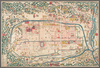
【Courtesy of the C. V. Starr East Asian Library University of California, Berkeley】 Wood block print. In Japanese. Title from: Kyoto zu somokuroku /Otsuka Takashi, p.35. Oriented with north to the left. Includes legend.
リンク: 出所・参照情報
|
1774 | 約3年 前 | 4個の基準点 |
|
Image from the Map Collections courtesy Stanford University Libraries, licensed under a Creative Commons Attribution-Noncommercial 3.0 Unported License. © Stanford University. 【図幅名】 鳥取南部 【測量時期】 明治30年測図/明治31年測図の縮図/昭和7年修正 【発行時期】 昭和9年8月発行 【記号】 鳥取16号(共9面) 【測量機関】 大日本帝国陸地測量部 【備考】
リンク: 出所・参照情報
|
19日 前 | 4個の基準点 | |
|
【Courtesy of the C. V. Starr East Asian Library University of California, Berkeley】 Lithograph. In Japanese. Oriented with north to the left. Relief shown by hachures. Includes legend.
リンク: 出所・参照情報
|
1901 | 約3年 前 | 4個の基準点 |