Browse Maps
| map | Title | Year | Last Updated | Status  |
|---|---|---|---|---|
|
|
2022 | about 2 years ago | 4 control points |
|
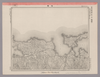
Image from the Map Collections courtesy Stanford University Libraries, licensed under a Creative Commons Attribution-Noncommercial 3.0 Unported License. © Stanford University. 【図幅名】 姫島 【測量時期】 明治35年測圖/昭和16年修正測圖 【発行時期】 【記号】 中津六号 【測量機関】 参謀本部 【備考】 祕
Links: Source / Biblio Ref
|
about 1 month ago | 4 control points | |
|
Image from the Map Collections courtesy Stanford University Libraries, licensed under a Creative Commons Attribution-Noncommercial 3.0 Unported License. © Stanford University. 【図幅名】 高知 【測量時期】 明治40年測図の縮図/昭和8年修正、測図の縮図 【発行時期】 昭和11年4月発行 【記号】 高知7号(共16面) 【測量機関】 大日本帝国陸地測量部 【備考】
Links: Source / Biblio Ref
|
22 days ago | 4 control points | |
|
Links: Source / Biblio Ref
|
2021 | almost 2 years ago | 7 control points |

|
この地図の作成に当たっては、国土地理院長の承認を得て、同院発行の20万分の1地勢図及び5万分の1地形図を使用した。(承認番号 平30情使、 第1148号)
Links: Source / Biblio Ref
|
1946 | almost 5 years ago | 4 control points |
|
(In 1 layer)
Links: Source / Biblio Ref
|
2020 | over 2 years ago | 3 control points |
|
Links: Source / Biblio Ref
|
2020 | almost 2 years ago | 13 control points |
|
Image from the Map Collections courtesy Stanford University Libraries, licensed under a Creative Commons Attribution-Noncommercial 3.0 Unported License. © Stanford University. 【図幅名】 石碆 【測量時期】 明治39年測図/昭和8年修正 【発行時期】 昭和11年4月発行 【記号】 窪川9号(共4面) 【測量機関】 大日本帝国陸地測量部 【備考】
Links: Source / Biblio Ref
|
2 days ago | 4 control points | |
|
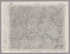
Image from the Map Collections courtesy Stanford University Libraries, licensed under a Creative Commons Attribution-Noncommercial 3.0 Unported License. © Stanford University. 【図幅名】 北川 【測量時期】 明治40年測圖/昭和8年修正測圖 【発行時期】 【記号】 剣山十四号 【測量機関】 参謀本部 【備考】 祕
Links: Source / Biblio Ref
|
2 days ago | 4 control points | |
|
Image from the Map Collections courtesy Stanford University Libraries, licensed under a Creative Commons Attribution-Noncommercial 3.0 Unported License. © Stanford University. 【図幅名】 仙崎 【測量時期】 明治30年測図/昭和2年要部修正/昭和7年鉄道補入 【発行時期】 昭和17年12月発行 【記号】 山口14号 【測量機関】 大日本帝国陸地測量部 【備考】
Links: Source / Biblio Ref
|
over 2 years ago | 4 control points | |
|
Image from the Map Collections courtesy Stanford University Libraries, licensed under a Creative Commons Attribution-Noncommercial 3.0 Unported License. © Stanford University. 【図幅名】 田野々 【測量時期】 明治39年測図/昭和8年修正 【発行時期】 昭和11年5月発行 【記号】 宇和島1号(共13面) 【測量機関】 大日本帝国陸地測量部 【備考】
Links: Source / Biblio Ref
|
2 days ago | 4 control points | |
|
|
2022 | about 2 years ago | 4 control points |
|
(In 1 layer)
Links: Source / Biblio Ref
|
2020 | over 2 years ago | 8 control points |
|
|
2022 | about 2 years ago | 4 control points |
|
Image from the Map Collections courtesy Stanford University Libraries, licensed under a Creative Commons Attribution-Noncommercial 3.0 Unported License. © Stanford University. 【図幅名】 奈半利 【測量時期】 明治40年測図/昭和8年修正 【発行時期】 昭和11年8月発行 【記号】 剣山16号(共11面) 【測量機関】 大日本帝国陸地測量部 【備考】
Links: Source / Biblio Ref
|
2 days ago | 4 control points | |
|
|
1863 | over 6 years ago | 5 control points |
|
立命館大学ARC古地図データベースより引用
|
2022 | over 1 year ago | 153 control points |
|
Image from the Map Collections courtesy Stanford University Libraries, licensed under a Creative Commons Attribution-Noncommercial 3.0 Unported License. © Stanford University. 【図幅名】 萩 【測量時期】 明治32年測圖/昭和2年要部修正測圖/昭和7年鐡道補入/昭和15年部分修正測圖 【発行時期】 【記号】 山口十号 【測量機関】 参謀本部 【備考】 祕
Links: Source / Biblio Ref
|
over 2 years ago | 4 control points | |
|
Image from the Map Collections courtesy Stanford University Libraries, licensed under a Creative Commons Attribution-Noncommercial 3.0 Unported License. © Stanford University. 【図幅名】 浜崎 【測量時期】 明治33年測圖/昭和11年修正測圖 【発行時期】 【記号】 小倉十六号 【測量機関】 参謀本部 【備考】 祕
Links: Source / Biblio Ref
|
about 1 month ago | 4 control points | |
|
Image from the Map Collections courtesy Stanford University Libraries, licensed under a Creative Commons Attribution-Noncommercial 3.0 Unported License. © Stanford University. 【図幅名】 塩尻 【測量時期】 明治43年測図/昭和6年修正、測図の縮図 【発行時期】 昭和9年4月発行 【記号】 高山4号(共16面) 【測量機関】 大日本帝国陸地測量部 【備考】
Links: Source / Biblio Ref
|
about 2 months ago | 4 control points | |
|
Image from the Map Collections courtesy Stanford University Libraries, licensed under a Creative Commons Attribution-Noncommercial 3.0 Unported License. © Stanford University. 【図幅名】 農家 【測量時期】 大正9年測圖/昭和20年部分修正測圖(空中寫眞測圖) 【発行時期】 【記号】 浦河六号 【測量機関】 参謀本部 【備考】 祕
Links: Source / Biblio Ref
|
over 2 years ago | 4 control points | |
|
Image from the Map Collections courtesy Stanford University Libraries, licensed under a Creative Commons Attribution-Noncommercial 3.0 Unported License. © Stanford University. 【図幅名】 甘木 【測量時期】 明治33年測圖之縮圖/昭和11年第三回修正測圖之縮圖/昭和13年測圖之縮圖 【発行時期】 【記号】 小倉八号 【測量機関】 参謀本部 【備考】 祕
Links: Source / Biblio Ref
|
about 2 months ago | 4 control points | |
|
|
1864 | over 6 years ago | 3 control points |
|
|
2022 | about 2 years ago | 5 control points |
|
|
2023 | 10 months ago | 4 control points |
|
Image from the Map Collections courtesy Stanford University Libraries, licensed under a Creative Commons Attribution-Noncommercial 3.0 Unported License. © Stanford University. 【図幅名】 小宝島 【測量時期】 昭和5年測圖(海上寫眞測量) 【発行時期】 昭和11年発行 【記号】 奄美大島要塞近傍三号 【測量機関】 陸地測量部・参謀本部 【備考】 軍事極祕(戦地ニ在りテハ軍事祕密トス) 假製版
Links: Source / Biblio Ref
|
about 2 months ago | 4 control points | |
|
Image from the Map Collections courtesy Stanford University Libraries, licensed under a Creative Commons Attribution-Noncommercial 3.0 Unported License. © Stanford University. 【図幅名】 臥蛇島 【測量時期】 昭和5年測圖(海上寫眞測量) 【発行時期】 昭和11年発行 【記号】 奄美大島要塞近傍一号 【測量機関】 陸地測量部・参謀本部 【備考】 軍事極祕(戦地ニ在りテハ軍事祕密トス) 假製版
Links: Source / Biblio Ref
|
about 2 months ago | 4 control points | |
|
Image from the Map Collections courtesy Stanford University Libraries, licensed under a Creative Commons Attribution-Noncommercial 3.0 Unported License. © Stanford University. 【図幅名】 豊後杵築 【測量時期】 明治36年測圖/昭和2年要部修正測圖 【発行時期】 【記号】 中津八号 【測量機関】 参謀本部 【備考】 祕
Links: Source / Biblio Ref
|
22 days ago | 4 control points | |
|
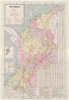
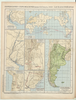
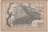
RIO SINU. PLANO GENERAL CORONEL P.R.WARREN. TECNICO HIDRAULICO. DIBUJADO POR LUIS ACEVEDO. 1 PARA ACOMPAÑAR AL INFORME DE SIR. A.GIBB G.B.C G.B. DEL 25 DE ABRIL-32
|
1932 | 11 months ago | 21 control points |
|
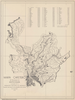
Image from the Map Collections courtesy Stanford University Libraries, licensed under a Creative Commons Attribution-Noncommercial 3.0 Unported License. © Stanford University. 【図幅名】 三島 【測量時期】 明治39年測図/昭和3年修正 【発行時期】 昭和7年1月発行 【記号】 高知5号(共16面) 【測量機関】 大日本帝国陸地測量部 【備考】 (In 1 layer)
Links: Source / Biblio Ref
|
about 2 months ago | 4 control points | |
|
Image from the Map Collections courtesy Stanford University Libraries, licensed under a Creative Commons Attribution-Noncommercial 3.0 Unported License. © Stanford University. 【図幅名】 焼尻島 【測量時期】 大正11年測図 【発行時期】 大正13年5月発行 【記号】 羽幌10号(共8面) 【測量機関】 大日本帝国陸地測量部 【備考】 仮製版 (In 1 layer)
Links: Source / Biblio Ref
|
about 2 months ago | 4 control points | |
|
Image from the Map Collections courtesy Stanford University Libraries, licensed under a Creative Commons Attribution-Noncommercial 3.0 Unported License. © Stanford University. 【図幅名】 大湊 【測量時期】 大正3年測図/昭和4年修正/昭和19年部分修正 【発行時期】 【記号】 辺地13号(共7面) 【測量機関】 内務省地理調査所 【備考】
Links: Source / Biblio Ref
|
22 days ago | 4 control points | |
|
国立国会図書館デジタルコレクション インターネット公開(保護期間満了) (In 2 layers)
Links: Source / Biblio Ref
|
1852 | almost 4 years ago | 29 control points |
|
Links: Source / Biblio Ref
|
2021 | over 1 year ago | 12 control points |
|
Links: Source / Biblio Ref
|
2020 | almost 2 years ago | 5 control points |
|
Image from the Map Collections courtesy Stanford University Libraries, licensed under a Creative Commons Attribution-Noncommercial 3.0 Unported License. © Stanford University.
Links: Source / Biblio Ref
|
over 6 years ago | 4 control points | |
|
Links: Source / Biblio Ref
|
2020 | almost 2 years ago | 4 control points |
|
この地図の作成に当たっては、国土地理院長の承認を得て、同院発行の20万分の1地勢図及び5万分の1地形図を使用した。(承認番号 平30情使、 第1148号)
Links: Source / Biblio Ref
|
1947 | 2 days ago | 4 control points |
|
Image from the Map Collections courtesy Stanford University Libraries, licensed under a Creative Commons Attribution-Noncommercial 3.0 Unported License. © Stanford University. 【図幅名】 甲浦 【測量時期】 明治40年測圖/昭和8年修正測圖 【発行時期】 【記号】 剣山十一号 【測量機関】 参謀本部 【備考】 祕
Links: Source / Biblio Ref
|
almost 6 years ago | 4 control points | |
|
Links: Source / Biblio Ref
|
2018 | over 6 years ago | 3 control points |
|
Image from the Map Collections courtesy Stanford University Libraries, licensed under a Creative Commons Attribution-Noncommercial 3.0 Unported License. © Stanford University. 【図幅名】 土佐長浜 【測量時期】 明治39年測図の縮図/昭和8年修正、測図の縮図 【発行時期】 昭和11年2月発行 【記号】 高知8号(共16面) 【測量機関】 大日本帝国陸地測量部 【備考】
Links: Source / Biblio Ref
|
22 days ago | 4 control points | |
|
Image from the Map Collections courtesy Stanford University Libraries, licensed under a Creative Commons Attribution-Noncommercial 3.0 Unported License. © Stanford University. 【図幅名】 安芸 【測量時期】 明治40年測図/昭和8年修正 【発行時期】 昭和11年1月発行 【記号】 高知4号(共16面) 【測量機関】 大日本帝国陸地測量部 【備考】
Links: Source / Biblio Ref
|
22 days ago | 4 control points | |
|
Image from the Map Collections courtesy Stanford University Libraries, licensed under a Creative Commons Attribution-Noncommercial 3.0 Unported License. © Stanford University. 【図幅名】 徳山 【測量時期】 明治32年測図/昭和2年修正/昭和7年鉄道補入/昭和24年資料修正 【発行時期】 昭和24年3月発行 【記号】 山口4号(共15面) 【測量機関】 地理調査所 【備考】
Links: Source / Biblio Ref
|
about 1 month ago | 4 control points | |
|
Links: Source / Biblio Ref
|
2021 | over 3 years ago | 31 control points |
|
|
2022 | about 2 years ago | 8 control points |
|
Image from the Map Collections courtesy Stanford University Libraries, licensed under a Creative Commons Attribution-Noncommercial 3.0 Unported License. © Stanford University. 【図幅名】 相島 【測量時期】 明治32年測図/昭和2年要部修正/昭和7年鉄道補入 【発行時期】 昭和9年8月発行 【記号】 山口9号(共15面) 【測量機関】 大日本帝国陸地測量部 【備考】
Links: Source / Biblio Ref
|
over 2 years ago | 4 control points | |
|
Image from the Map Collections courtesy Stanford University Libraries, licensed under a Creative Commons Attribution-Noncommercial 3.0 Unported License. © Stanford University.
Links: Source / Biblio Ref
|
over 6 years ago | 4 control points | |
|
Image from the Map Collections courtesy Stanford University Libraries, licensed under a Creative Commons Attribution-Noncommercial 3.0 Unported License. © Stanford University. 【図幅名】 福山 【測量時期】 明治31年測図/大正14年第2回修正 【発行時期】 【記号】 岡山及丸亀10号(共14面) 【測量機関】 参謀本部 【備考】 秘
Links: Source / Biblio Ref
|
about 2 months ago | 4 control points | |
|
Image from the Map Collections courtesy Stanford University Libraries, licensed under a Creative Commons Attribution-Noncommercial 3.0 Unported License. © Stanford University. 【図幅名】 佐須余 【測量時期】 大正11年測図の縮図/昭和10年修正、測図の縮図 【発行時期】 昭和21年11月発行 【記号】 厳原9号(共7面) 【測量機関】 内務省地理調査所 【備考】
Links: Source / Biblio Ref
|
about 1 month ago | 4 control points | |
|
|
1864 | over 6 years ago | 6 control points |