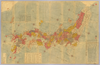
【Courtesy of the C. V. Starr East Asian Library University of California, Berkeley】 1 map : col. ; on sheet 85 x 113 cm., folded in cover 29 x 17 cm. Mounted cover title. Wood block print. Oriented with north toward the upper right. In Japanese. Engraved by Hata Kyube. Covers Matsumae to Tanegashima, Yakushima, and Tsushima. Shows longitude and latitude and sea routes with distances. Includes texts on Kuroshio and tides. Includes preface by Shibano Ritsuzan and legend. East Asian Library call number Ca 14. アップロード者: ima. 作成: 1791 最終更新日時 5年以上 前. 5個の基準点.
タグ
リンク: 出所・参照情報 | KMLをダウンロードする |
 WMS CapabilitiesのURL
 タイル(Google・OSMのフォーマット)
 基準点をCSVでダウンロードする