日本版 Map Warper

ログイン アカウント作成
日本語 (ja)
ホーム > 地図 > 地図4204
Bl 01 0246 nqxighjk 輿地航海図 Yochi kokai zu Map of navigational routes
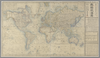
shelfmark: Maps 920.150 License: Public Domain 安政5 *手彩色。外題「輿地航海図」。無刊記。内題横に「原刻一千八百四十五年」とあり。例言に庸普爾地は「イヨンビュルヂ」と振ってある。 Xylograph. Acquired 10 June 1869. Beans 42 he is mistaken in describing this map as ‘copper-engraved’. Iyonbyuruji is the Japanese representation of the name of JohnPurdy, said in the tExt to have been the original maker of the map, published in 1845; this is probably a reference to his A chart of the world, on Mercator's Projection; with the tracks of the more distinguished modern navigators, which was first published in 1810. アップロード者: autobot. 作成: 1858 最終更新日時 4年以上 前. 整形を解除する.
タグ British Library 大英図書館
リンク: 出所・参照情報
Share |
Kml logo 20x25 エクスポート

メタデータ

タイトル
輿地航海図 Yochi kokai zu [Map of navigational routes]

説明
shelfmark: Maps 920.(150) License: Public Domain 安政5 *手彩色。外題「輿地航海図」。無刊記。内題横に「原刻一千八百四十五年」とあり。例言に庸普爾地は「イヨンビュルヂ」と振ってある。 Xylograph. Acquired 10 June 1869. Beans 42 (he is mistaken in describing this map as ‘copper-engraved’). Iyonbyuruji is the Japanese representation of the name of JohnPurdy, said in the tExt to have been the original maker of the map, published in 1845; this is probably a reference to his A chart of the world, on Mercator's Projection; with the tracks of the more distinguished modern navigators, which was first published in 1810.

タグ: British Library 大英図書館

is_map

出所・参照情報のURL
https://www.bl.uk/

出版者
樹徳堂蔵板

作成者
英国・庸普爾地緝、杉田玄端閲、武田簡吾訳 Iyonbyuruji [John Purdy (1773-1843)]; edited by Sugita Gentan (1818-1889) and translated by Takeda Kango

縮尺

出版年月日

再版年月日

修正を提案する