Japanese Map Warper

Log In Create Account
English (en)
Home > Maps > Map 4219
Bl 01 0261 yrjbkvqg 皇国官弊官社府県全図 Kokoku kanhei kansha fuken zenzu Complete administrative map of our imperial country
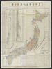
shelfmark: Maps 38.b.171 License: Public Domain 明治8 *銅板。多色刷り。外題「(蒔田愛敬編輯)皇国新図(附府県官弊国弊社)」。北海道・樺太・千島列島・琉球諸島等を含む。 Copperplate. Includes Hokkaido, Karafuto i.e., Sakhalin, the Chishima archipelago i.e., Kurile Islands and the Ryukyu islands i.e., Okinawa Prefecture. Uploaded by autobot. Depicts: 1875 Last modified about 3 years ago. 25 control points.
Tags British Library 大英図書館
Links: Source / Biblio Ref | Download KML
Share |
Kml logo 20x25 Export

Metadata

Title
皇国官弊官社府県全図 Kokoku kanhei kansha fuken zenzu [Complete administrative map of our imperial country]

Description
shelfmark: Maps 38.b.17(1) License: Public Domain 明治8 *銅板。多色刷り。外題「(蒔田愛敬編輯)皇国新図(附府県官弊国弊社)」。北海道・樺太・千島列島・琉球諸島等を含む。 Copperplate. Includes Hokkaido, Karafuto (i.e., Sakhalin), the Chishima archipelago (i.e., Kurile Islands) and the Ryukyu islands (i.e., Okinawa Prefecture).

Tags: British Library 大英図書館

is_map

Source / Bibliographic Ref URL
https://www.bl.uk/

Publisher
Published in 1875 (np)

Author(s)
蒔田愛敬編 Makita Aikei

Scale

Published Date

Reprint Date

修正を提案する