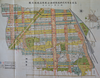
則武耕地整理組合における整理実施後の土地指定図を元に、組合から市へ移管する道路の位置を指し示したもの。数多くの水路が描かれているが、これら全てが実現したものかどうかは不明である。 Uploaded by ysh. Last modified about 5 years ago. 12 control points.
| Download KML |
|
|
名古屋市則武耕地整理組合使用土地指定図
則武耕地整理組合における整理実施後の土地指定図を元に、組合から市へ移管する道路の位置を指し示したもの。数多くの水路が描かれているが、これら全てが実現したものかどうかは不明である。 Uploaded by ysh. Last modified about 5 years ago. 12 control points. | Download KML | |
 WMS Capabilities URL
 Tiles (Google/OSM scheme)
 Download control points as CSV