Uploaded by Keiji_Yano. (In 1 layer) Depicts: 1923 Last modified 11 months ago. 4 control points.
Tags
Links: Source / Biblio Ref | Download KML |
|
|
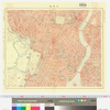
東京市火災動態地図(日本橋)
Uploaded by Keiji_Yano. (In 1 layer) Depicts: 1923 Last modified 11 months ago. 4 control points. Tags Links: Source / Biblio Ref | Download KML | |
 WMS Capabilities URL
 Tiles (Google/OSM scheme)
 Download control points as CSV