|
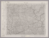
『卯之町』五万分一地形圖
Image from the Map Collections courtesy Stanford University Libraries, licensed under a Creative Commons Attribution-Noncommercial 3.0 Unported License. © Stanford University. 【図幅名】 卯之町 【測量時期】 明治37年測図/昭和8年修正/昭和22年資料修正 【発行時期】 昭和22年11月発行 【記号】 松山8号(共15面) 【測量機関】 地理調査所 【備考】 Uploaded by autobot. (In 1 layer) Last modified almost 8 years ago. 4 control points. Links: Source / Biblio Ref | Download KML | |
 WMS Capabilities URL
 Tiles (Google/OSM scheme)
 Download control points as CSV
Mosaic List for Map 588
| Mosaic | Title | Year | Last Updated | Number of Maps | Percentage Complete |
|---|---|---|---|---|---|
|
愛媛五万分一地形圖
Compiled by shapez. Download KML |
10 months ago | 26 maps |
100% (26 maps) |
Displaying 1 layer per page