|
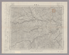
『上野原』五万分一地形圖
Image from the Map Collections courtesy Stanford University Libraries, licensed under a Creative Commons Attribution-Noncommercial 3.0 Unported License. © Stanford University. 【図幅名】 上野原 【測量時期】 明治21年測図/昭和4年第3回修正 【発行時期】 昭和8年2月発行 【記号】 東京15号 【測量機関】 大日本帝国陸地測量部 【備考】 Uploaded by autobot. (In 1 layer) Last modified almost 8 years ago. 4 control points. Links: Source / Biblio Ref | Download KML | |
 WMS Capabilities URL
 Tiles (Google/OSM scheme)
 Download control points as CSV
Mosaic List for Map 879
| Mosaic | Title | Year | Last Updated | Number of Maps | Percentage Complete |
|---|---|---|---|---|---|
|
関東地方旧版地形図
関東地方の旧版地形図モザイク Compiled by habs.niaes. Download KML |
1920 | over 1 year ago | 78 maps |
100% (78 maps) |
Displaying 1 layer per page