Tags for 満州
| Map | Title | Year | Last Updated  |
Status |
|---|---|---|---|---|
|
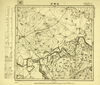
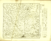
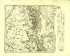
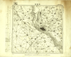
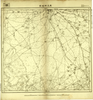
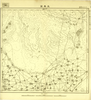
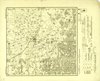
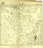
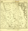
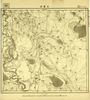
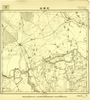
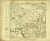
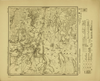
Image from the Map Collections courtesy Tohoku University. © 2023, the Committee for the Creation of the Gaihozu Digital Archives. 【図幅名】 茂興站 【測量時期】 - 【発行時期】 昭和8年発行 【記号】 白城子4号 【測量機関】 大日本帝國陸地測量部
Links: Source / Biblio Ref
|
1933 | 2 months ago | 4 control points |
|
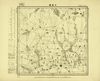
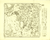
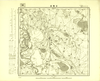
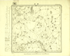
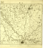
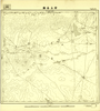
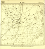
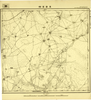
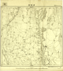
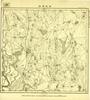
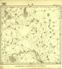
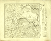
Image from the Map Collections courtesy Tohoku University. © 2023, the Committee for the Creation of the Gaihozu Digital Archives. 【図幅名】 大通鎮 【測量時期】 - 【発行時期】 昭和8年発行 【記号】 白城子2号 【測量機関】 大日本帝國陸地測量部
Links: Source / Biblio Ref
|
1933 | 2 months ago | 4 control points |
|
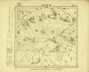
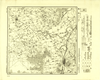
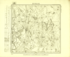
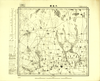
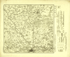
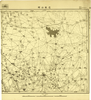
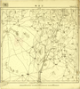
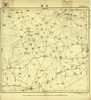
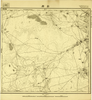
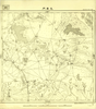
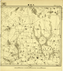
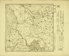
Image from the Map Collections courtesy Tohoku University. © 2023, the Committee for the Creation of the Gaihozu Digital Archives. 【図幅名】 軋葫芦泡 【測量時期】 - 【発行時期】 昭和10年発行 【記号】 白城子1号 【測量機関】 大日本帝國陸地測量部
Links: Source / Biblio Ref
|
1935 | 2 months ago | 4 control points |
|
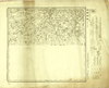
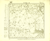
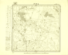
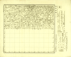
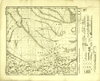
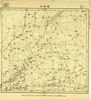
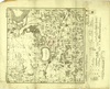
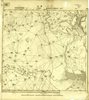
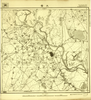
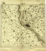
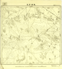
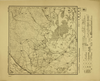
Image from the Map Collections courtesy Tohoku University. © 2023, the Committee for the Creation of the Gaihozu Digital Archives. 【図幅名】 洮南南部 【測量時期】 昭和8年昭和9年測圖ショウワネン 【発行時期】 昭和11年発行 【記号】 洮安25号 【測量機関】 大日本帝國陸地測量部
Links: Source / Biblio Ref
|
1936 | 2 months ago | 4 control points |
|
Image from the Map Collections courtesy Tohoku University. © 2023, the Committee for the Creation of the Gaihozu Digital Archives. 【図幅名】 洮南北部 【測量時期】 昭和8年測圖 【発行時期】 昭和11年発行 【記号】 洮安24号 【測量機関】 大日本帝國陸地測量部
Links: Source / Biblio Ref
|
1936 | 2 months ago | 4 control points |

|
Image from the Map Collections courtesy Tohoku University. © 2023, the Committee for the Creation of the Gaihozu Digital Archives. 【図幅名】 太本站 【測量時期】 - 【発行時期】 昭和11年発行 【記号】 洮安23号 【測量機関】 大日本帝國陸地測量部
Links: Source / Biblio Ref
|
1936 | 2 months ago | 4 control points |
|
Image from the Map Collections courtesy Tohoku University. © 2023, the Committee for the Creation of the Gaihozu Digital Archives. 【図幅名】 東屏 【測量時期】 昭和8年測圖 【発行時期】 昭和11年発行 【記号】 洮安17号ゴウ 【測量機関】 大日本帝國陸地測量部
Links: Source / Biblio Ref
|
1936 | 2 months ago | 4 control points |
|
Image from the Map Collections courtesy Tohoku University. © 2023, the Committee for the Creation of the Gaihozu Digital Archives. 【図幅名】 泰来 【測量時期】 昭和8年測圖 【発行時期】 昭和10年発行 【記号】 洮安16号ゴウ 【測量機関】 大日本帝國陸地測量部
Links: Source / Biblio Ref
|
1935 | 2 months ago | 4 control points |
|
Image from the Map Collections courtesy Tohoku University. © 2023, the Committee for the Creation of the Gaihozu Digital Archives. 【図幅名】 西二龍索口 【測量時期】 - 【発行時期】 昭和8年発行 【記号】 洮安13号 【測量機関】 大日本帝國陸地測量部
Links: Source / Biblio Ref
|
1933 | 2 months ago | 4 control points |
|
Image from the Map Collections courtesy Tohoku University. © 2023, the Committee for the Creation of the Gaihozu Digital Archives. 【図幅名】 多耐站 【測量時期】 昭和8年測圖sネンソクズ 【発行時期】 昭和10年発行 【記号】 洮安11号 【測量機関】 大日本帝國陸地測量部
Links: Source / Biblio Ref
|
1935 | 2 months ago | 4 control points |
|
Image from the Map Collections courtesy Tohoku University. © 2023, the Committee for the Creation of the Gaihozu Digital Archives. 【図幅名】 古魯站 【測量時期】 - 【発行時期】 昭和8年発行 【記号】 洮安8号ゴウ 【測量機関】 大日本帝國陸地測量部
Links: Source / Biblio Ref
|
1933 | 2 months ago | 4 control points |
|
Image from the Map Collections courtesy Tohoku University. © 2023, the Committee for the Creation of the Gaihozu Digital Archives. 【図幅名】 他拉哈站 【測量時期】 - 【発行時期】 昭和8年発行 【記号】 洮安7号ゴウ 【測量機関】 大日本帝國陸地測量部
Links: Source / Biblio Ref
|
1933 | 2 months ago | 4 control points |
|
Image from the Map Collections courtesy Tohoku University. © 2023, the Committee for the Creation of the Gaihozu Digital Archives. 【図幅名】 九扇門 【測量時期】 - 【発行時期】 昭和10年発行 【記号】 洮安6号ゴウ 【測量機関】 大日本帝國陸地測量部
Links: Source / Biblio Ref
|
1935 | 2 months ago | 4 control points |
|
Image from the Map Collections courtesy Tohoku University. © 2023, the Committee for the Creation of the Gaihozu Digital Archives. 【図幅名】 伯都訥 【測量時期】 - 【発行時期】 昭和8年発行 【記号】 洮安5号ゴウ 【測量機関】 大日本帝國陸地測量部
Links: Source / Biblio Ref
|
1933 | 2 months ago | 4 control points |
|
Image from the Map Collections courtesy Tohoku University. © 2023, the Committee for the Creation of the Gaihozu Digital Archives. 【図幅名】 頭台 【測量時期】 - 【発行時期】 昭和8年発行 【記号】 洮安3号 【測量機関】 大日本帝國陸地測量部
Links: Source / Biblio Ref
|
1933 | 2 months ago | 4 control points |
|
Image from the Map Collections courtesy Tohoku University. © 2023, the Committee for the Creation of the Gaihozu Digital Archives. 【図幅名】 大通鎮 【測量時期】 - 【発行時期】 昭和8年発行 【記号】 洮安2号 【測量機関】 大日本帝國陸地測量部
Links: Source / Biblio Ref
|
1933 | 2 months ago | 4 control points |
|
Image from the Map Collections courtesy Tohoku University. © 2023, the Committee for the Creation of the Gaihozu Digital Archives. 【図幅名】 洮南南部 【測量時期】 昭和8年昭和9年測圖之縮図 【発行時期】 - 【記号】 西五行北七段伯都訥25号 【測量機関】 大日本帝國陸地測量部
Links: Source / Biblio Ref
|
2 months ago | 4 control points | |
|
Image from the Map Collections courtesy Tohoku University. © 2023, the Committee for the Creation of the Gaihozu Digital Archives. 【図幅名】 前又杆他拉 【測量時期】 - 【発行時期】 - 【記号】 西五行北七段伯都訥25号 【測量機関】 -
Links: Source / Biblio Ref
|
2 months ago | 4 control points | |
|
Image from the Map Collections courtesy Tohoku University. © 2023, the Committee for the Creation of the Gaihozu Digital Archives. 【図幅名】 洮南 【測量時期】 - 【発行時期】 - 【記号】 西五行北七段伯都訥24号 【測量機関】 -
Links: Source / Biblio Ref
|
2 months ago | 4 control points | |
|
Image from the Map Collections courtesy Tohoku University. © 2023, the Committee for the Creation of the Gaihozu Digital Archives. 【図幅名】 洮南北部 【測量時期】 昭和8年測圖之縮図 【発行時期】 - 【記号】 西五行北七段伯都訥24号 【測量機関】 大日本帝國陸地測量部
Links: Source / Biblio Ref
|
2 months ago | 4 control points | |
|
Image from the Map Collections courtesy Tohoku University. © 2023, the Committee for the Creation of the Gaihozu Digital Archives. 【図幅名】 太本站 【測量時期】 - 【発行時期】 - 【記号】 西五行北七段伯都訥23号 【測量機関】 -
Links: Source / Biblio Ref
|
2 months ago | 4 control points | |
|
Image from the Map Collections courtesy Tohoku University. © 2023, the Committee for the Creation of the Gaihozu Digital Archives. 【図幅名】 太本站 【測量時期】 - 【発行時期】 - 【記号】 西五行北七段伯都訥23号 【測量機関】 -
Links: Source / Biblio Ref
|
2 months ago | 4 control points | |
|
Image from the Map Collections courtesy Tohoku University. © 2023, the Committee for the Creation of the Gaihozu Digital Archives. 【図幅名】 阿立各圖 【測量時期】 - 【発行時期】 - 【記号】 西五行北七段伯都訥22号 【測量機関】 -
Links: Source / Biblio Ref
|
2 months ago | 4 control points | |
|
Image from the Map Collections courtesy Tohoku University. © 2023, the Committee for the Creation of the Gaihozu Digital Archives. 【図幅名】 巴拉山昭 【測量時期】 - 【発行時期】 - 【記号】 西五行北七段伯都訥20号 【測量機関】 -
Links: Source / Biblio Ref
|
2 months ago | 4 control points | |
|
Image from the Map Collections courtesy Tohoku University. © 2023, the Committee for the Creation of the Gaihozu Digital Archives. 【図幅名】 寳興屯 【測量時期】 - 【発行時期】 - 【記号】 西五行北七段伯都訥19号 【測量機関】 -
Links: Source / Biblio Ref
|
2 months ago | 4 control points | |
|
Image from the Map Collections courtesy Tohoku University. © 2023, the Committee for the Creation of the Gaihozu Digital Archives. 【図幅名】 鎮東 【測量時期】 昭和8年昭和9年測圖之縮図ショウワネンショウワネンソクズノシュクズ 【発行時期】 - 【記号】 西五行北七段伯都訥18号 【測量機関】 大日本帝國陸地測量部
Links: Source / Biblio Ref
|
2 months ago | 4 control points | |
|
Image from the Map Collections courtesy Tohoku University. © 2023, the Committee for the Creation of the Gaihozu Digital Archives. 【図幅名】 鎮東縣 【測量時期】 - 【発行時期】 - 【記号】 西五行北七段伯都訥18号 【測量機関】 -
Links: Source / Biblio Ref
|
2 months ago | 4 control points | |
|
Image from the Map Collections courtesy Tohoku University. © 2023, the Committee for the Creation of the Gaihozu Digital Archives. 【図幅名】 公合勒 【測量時期】 - 【発行時期】 - 【記号】 西五行北七段伯都訥17号 【測量機関】 -
Links: Source / Biblio Ref
|
2 months ago | 4 control points | |
|
Image from the Map Collections courtesy Tohoku University. © 2023, the Committee for the Creation of the Gaihozu Digital Archives. 【図幅名】 東屏 【測量時期】 昭和8年測圖之縮図sネンソクズノシュクズ 【発行時期】 - 【記号】 西五行北七段伯都訥17号 【測量機関】 大日本帝國陸地測量部
Links: Source / Biblio Ref
|
2 months ago | 4 control points | |
|
Image from the Map Collections courtesy Tohoku University. © 2023, the Committee for the Creation of the Gaihozu Digital Archives. 【図幅名】 泰来 【測量時期】 - 【発行時期】 - 【記号】 西五行北七段伯都訥16号 【測量機関】 -
Links: Source / Biblio Ref
|
2 months ago | 4 control points | |
|
Image from the Map Collections courtesy Tohoku University. © 2023, the Committee for the Creation of the Gaihozu Digital Archives. 【図幅名】 高家窩棚 【測量時期】 - 【発行時期】 - 【記号】 西五行北七段伯都訥15号 【測量機関】 -
Links: Source / Biblio Ref
|
2 months ago | 4 control points | |
|
Image from the Map Collections courtesy Tohoku University. © 2023, the Committee for the Creation of the Gaihozu Digital Archives. 【図幅名】 安廣 【測量時期】 - 【発行時期】 - 【記号】 西五行北七段伯都訥14号 【測量機関】 支那駐屯軍司令部シナチュウトングンシレイブ
Links: Source / Biblio Ref
|
2 months ago | 4 control points | |
|
Image from the Map Collections courtesy Tohoku University. © 2023, the Committee for the Creation of the Gaihozu Digital Archives. 【図幅名】 西二龍索口 【測量時期】 - 【発行時期】 - 【記号】 西五行北七段伯都訥13号 【測量機関】 -
Links: Source / Biblio Ref
|
2 months ago | 4 control points | |
|
Image from the Map Collections courtesy Tohoku University. © 2023, the Committee for the Creation of the Gaihozu Digital Archives. 【図幅名】 馬爾根山 【測量時期】 - 【発行時期】 - 【記号】 西五行北七段伯都訥12号 【測量機関】 -
Links: Source / Biblio Ref
|
2 months ago | 4 control points | |
|
Image from the Map Collections courtesy Tohoku University. © 2023, the Committee for the Creation of the Gaihozu Digital Archives. 【図幅名】 多耐站 【測量時期】 - 【発行時期】 - 【記号】 西五行北七段伯都訥11号 【測量機関】 -
Links: Source / Biblio Ref
|
2 months ago | 4 control points | |
|
Image from the Map Collections courtesy Tohoku University. © 2023, the Committee for the Creation of the Gaihozu Digital Archives. 【図幅名】 新廟 【測量時期】 - 【発行時期】 - 【記号】 西五行北七段伯都訥10号 【測量機関】 -
Links: Source / Biblio Ref
|
2 months ago | 4 control points | |
|
Image from the Map Collections courtesy Tohoku University. © 2023, the Committee for the Creation of the Gaihozu Digital Archives. 【図幅名】 大賚 【測量時期】 - 【発行時期】 - 【記号】 西五行北七段伯都訥9号 【測量機関】 -
Links: Source / Biblio Ref
|
2 months ago | 4 control points | |
|
Image from the Map Collections courtesy Tohoku University. © 2023, the Committee for the Creation of the Gaihozu Digital Archives. 【図幅名】 古魯站 【測量時期】 - 【発行時期】 - 【記号】 西五行北七段伯都訥8号 【測量機関】 -
Links: Source / Biblio Ref
|
2 months ago | 4 control points | |
|
Image from the Map Collections courtesy Tohoku University. © 2023, the Committee for the Creation of the Gaihozu Digital Archives. 【図幅名】 他拉哈站 【測量時期】 - 【発行時期】 - 【記号】 西五行北七段伯都訥7号 【測量機関】 -
Links: Source / Biblio Ref
|
2 months ago | 4 control points | |
|
Image from the Map Collections courtesy Tohoku University. © 2023, the Committee for the Creation of the Gaihozu Digital Archives. 【図幅名】 九扇門 【測量時期】 - 【発行時期】 - 【記号】 西五行北七段伯都訥6号 【測量機関】 -
Links: Source / Biblio Ref
|
2 months ago | 4 control points | |
|
Image from the Map Collections courtesy Tohoku University. © 2023, the Committee for the Creation of the Gaihozu Digital Archives. 【図幅名】 伯都訥 【測量時期】 明治41年測圖/大正15年修正測圖mネンソクズ 【発行時期】 - 【記号】 西五行北七段伯都訥5号 【測量機関】 -
Links: Source / Biblio Ref
|
2 months ago | 4 control points | |
|
Image from the Map Collections courtesy Tohoku University. © 2023, the Committee for the Creation of the Gaihozu Digital Archives. 【図幅名】 茂興站 【測量時期】 - 【発行時期】 - 【記号】 西五行北七段伯都訥4号 【測量機関】 -
Links: Source / Biblio Ref
|
2 months ago | 4 control points | |
|
Image from the Map Collections courtesy Tohoku University. © 2023, the Committee for the Creation of the Gaihozu Digital Archives. 【図幅名】 頭台 【測量時期】 - 【発行時期】 - 【記号】 西五行北七段伯都訥3号 【測量機関】 -
Links: Source / Biblio Ref
|
2 months ago | 4 control points | |
|
Image from the Map Collections courtesy Tohoku University. © 2023, the Committee for the Creation of the Gaihozu Digital Archives. 【図幅名】 大通鎮 【測量時期】 - 【発行時期】 - 【記号】 西五行北七段伯都訥2号 【測量機関】 -
Links: Source / Biblio Ref
|
2 months ago | 4 control points | |
|
Image from the Map Collections courtesy Tohoku University. © 2023, the Committee for the Creation of the Gaihozu Digital Archives. 【図幅名】 軋葫芦泡 【測量時期】 大正7年測圖 【発行時期】 - 【記号】 西五行北七段伯都訥1号 【測量機関】 -
Links: Source / Biblio Ref
|
2 months ago | 4 control points | |
|
Image from the Map Collections courtesy Tohoku University. © 2023, the Committee for the Creation of the Gaihozu Digital Archives. 【図幅名】 茂興站 【測量時期】 - 【発行時期】 昭和8年発行 【記号】 西五行北七段白城子4号ニシ5ギョウキタナナダン 【測量機関】 大日本帝國陸地測量部
Links: Source / Biblio Ref
|
1933 | 2 months ago | 4 control points |
|
Image from the Map Collections courtesy Tohoku University. © 2023, the Committee for the Creation of the Gaihozu Digital Archives. 【図幅名】 頭站 【測量時期】 昭和8年測圖sネンソクズ 【発行時期】 昭和10年発行 【記号】 齊齊哈爾20号 【測量機関】 大日本帝國陸地測量部
Links: Source / Biblio Ref
|
1935 | 2 months ago | 4 control points |
|
Image from the Map Collections courtesy Tohoku University. © 2023, the Committee for the Creation of the Gaihozu Digital Archives. 【図幅名】 景星 【測量時期】 - 【発行時期】 昭和10年発行 【記号】 齊齊哈爾19号 【測量機関】 大日本帝國陸地測量部
Links: Source / Biblio Ref
|
1935 | 2 months ago | 4 control points |
|
Image from the Map Collections courtesy Tohoku University. © 2023, the Committee for the Creation of the Gaihozu Digital Archives. 【図幅名】 梁家大崗子 【測量時期】 昭和8年測圖sネンソクズ 【発行時期】 昭和10年発行 【記号】 齊齊哈爾18号 【測量機関】 大日本帝國陸地測量部
Links: Source / Biblio Ref
|
1935 | 2 months ago | 4 control points |
|
Image from the Map Collections courtesy Tohoku University. © 2023, the Committee for the Creation of the Gaihozu Digital Archives. 【図幅名】 江橋 【測量時期】 昭和8年測圖sネンソクズ 【発行時期】 昭和10年発行 【記号】 齊齊哈爾15号 【測量機関】 大日本帝國陸地測量部
Links: Source / Biblio Ref
|
1935 | 2 months ago | 4 control points |