タグ 満州
| 地図 | タイトル | 年 | 前回の更新  |
ステータス |
|---|---|---|---|---|
|
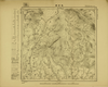
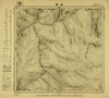
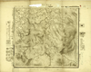
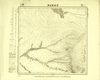
Image from the Map Collections courtesy Tohoku University. © 2023, the Committee for the Creation of the Gaihozu Digital Archives. 【図幅名】 烏吉密河 【測量時期】 - 【発行時期】 昭和7年発行sネンハッコウ 【記号】 依蘭25号 【測量機関】 大日本帝國陸地測量部
リンク: 出所・参照情報
|
1932 | 2ヶ月 前 | 4個の基準点 |
|
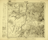
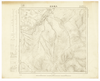
Image from the Map Collections courtesy Tohoku University. © 2023, the Committee for the Creation of the Gaihozu Digital Archives. 【図幅名】 黑龍宮 【測量時期】 - 【発行時期】 昭和7年発行sネンハッコウ 【記号】 依蘭24号 【測量機関】 大日本帝國陸地測量部
リンク: 出所・参照情報
|
1932 | 2ヶ月 前 | 4個の基準点 |
|
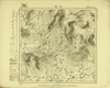
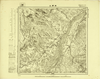
Image from the Map Collections courtesy Tohoku University. © 2023, the Committee for the Creation of the Gaihozu Digital Archives. 【図幅名】 枷板站 【測量時期】 - 【発行時期】 昭和7年発行sネンハッコウ 【記号】 依蘭23号 【測量機関】 大日本帝國陸地測量部
リンク: 出所・参照情報
|
1932 | 2ヶ月 前 | 4個の基準点 |
|
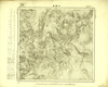
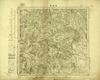
Image from the Map Collections courtesy Tohoku University. © 2023, the Committee for the Creation of the Gaihozu Digital Archives. 【図幅名】 石頭河子 【測量時期】 - 【発行時期】 昭和7年発行sネンハッコウ 【記号】 依蘭22号 【測量機関】 大日本帝國陸地測量部
リンク: 出所・参照情報
|
1932 | 2ヶ月 前 | 4個の基準点 |
|
Image from the Map Collections courtesy Tohoku University. © 2023, the Committee for the Creation of the Gaihozu Digital Archives. 【図幅名】 東興 【測量時期】 - 【発行時期】 昭和10年発行 【記号】 依蘭21号 【測量機関】 大日本帝國陸地測量部
リンク: 出所・参照情報
|
1935 | 2ヶ月 前 | 4個の基準点 |
|
Image from the Map Collections courtesy Tohoku University. © 2023, the Committee for the Creation of the Gaihozu Digital Archives. 【図幅名】 一面坡 【測量時期】 - 【発行時期】 昭和7年発行sネンハッコウ 【記号】 依蘭20号 【測量機関】 大日本帝國陸地測量部
リンク: 出所・参照情報
|
1932 | 2ヶ月 前 | 4個の基準点 |
|
Image from the Map Collections courtesy Tohoku University. © 2023, the Committee for the Creation of the Gaihozu Digital Archives. 【図幅名】 同賓縣 【測量時期】 - 【発行時期】 昭和8年発行sネンハッコウ 【記号】 依蘭19号 【測量機関】 大日本帝國陸地測量部
リンク: 出所・参照情報
|
1933 | 2ヶ月 前 | 4個の基準点 |
|
Image from the Map Collections courtesy Tohoku University. © 2023, the Committee for the Creation of the Gaihozu Digital Archives. 【図幅名】 木蘭縣 【測量時期】 - 【発行時期】 昭和7年発行sネンハッコウ 【記号】 依蘭18号 【測量機関】 大日本帝國陸地測量部
リンク: 出所・参照情報
|
1932 | 2ヶ月 前 | 4個の基準点 |
|
Image from the Map Collections courtesy Tohoku University. © 2023, the Committee for the Creation of the Gaihozu Digital Archives. 【図幅名】 老石房 【測量時期】 - 【発行時期】 昭和7年発行sネンハッコウ 【記号】 依蘭17号 【測量機関】 大日本帝國陸地測量部
リンク: 出所・参照情報
|
1932 | 2ヶ月 前 | 4個の基準点 |
|
Image from the Map Collections courtesy Tohoku University. © 2023, the Committee for the Creation of the Gaihozu Digital Archives. 【図幅名】 亮珠河 【測量時期】 - 【発行時期】 昭和7年発行sネンハッコウ 【記号】 依蘭15号 【測量機関】 大日本帝國陸地測量部
リンク: 出所・参照情報
|
1932 | 2ヶ月 前 | 4個の基準点 |
|
Image from the Map Collections courtesy Tohoku University. © 2023, the Committee for the Creation of the Gaihozu Digital Archives. 【図幅名】 三站 【測量時期】 - 【発行時期】 昭和7年発行sネンハッコウ 【記号】 依蘭12号 【測量機関】 大日本帝國陸地測量部
リンク: 出所・参照情報
|
1932 | 2ヶ月 前 | 4個の基準点 |
|
Image from the Map Collections courtesy Tohoku University. © 2023, the Committee for the Creation of the Gaihozu Digital Archives. 【図幅名】 芳家溝 【測量時期】 - 【発行時期】 昭和8年発行sネンハッコウ 【記号】 依蘭10号 【測量機関】 大日本帝國陸地測量部
リンク: 出所・参照情報
|
1933 | 2ヶ月 前 | 4個の基準点 |
|
Image from the Map Collections courtesy Tohoku University. © 2023, the Committee for the Creation of the Gaihozu Digital Archives. 【図幅名】 老嶺 【測量時期】 - 【発行時期】 昭和8年発行sネンハッコウ 【記号】 依蘭9号 【測量機関】 大日本帝國陸地測量部
リンク: 出所・参照情報
|
1933 | 2ヶ月 前 | 4個の基準点 |
|
Image from the Map Collections courtesy Tohoku University. © 2023, the Committee for the Creation of the Gaihozu Digital Archives. 【図幅名】 大羅勒密 【測量時期】 - 【発行時期】 昭和7年発行sネンハッコウ 【記号】 依蘭8号 【測量機関】 大日本帝國陸地測量部
リンク: 出所・参照情報
|
1932 | 2ヶ月 前 | 4個の基準点 |
|
Image from the Map Collections courtesy Tohoku University. © 2023, the Committee for the Creation of the Gaihozu Digital Archives. 【図幅名】 祥順山 【測量時期】 - 【発行時期】 昭和7年発行sネンハッコウ 【記号】 依蘭7号 【測量機関】 大日本帝國陸地測量部
リンク: 出所・参照情報
|
1932 | 2ヶ月 前 | 4個の基準点 |
|
Image from the Map Collections courtesy Tohoku University. © 2023, the Committee for the Creation of the Gaihozu Digital Archives. 【図幅名】 黑龍宮 【測量時期】 - 【発行時期】 昭和7年発行sネンハッコウ 【記号】 三姓24号 【測量機関】 大日本帝國陸地測量部
リンク: 出所・参照情報
|
1932 | 2ヶ月 前 | 4個の基準点 |
|
Image from the Map Collections courtesy Tohoku University. © 2023, the Committee for the Creation of the Gaihozu Digital Archives. 【図幅名】 枷板站 【測量時期】 - 【発行時期】 昭和7年発行sネンハッコウ 【記号】 三姓23号 【測量機関】 大日本帝國陸地測量部
リンク: 出所・参照情報
|
1932 | 2ヶ月 前 | 4個の基準点 |
|
Image from the Map Collections courtesy Tohoku University. © 2023, the Committee for the Creation of the Gaihozu Digital Archives. 【図幅名】 東興 【測量時期】 - 【発行時期】 昭和10年発行 【記号】 三姓21号 【測量機関】 大日本帝國陸地測量部
リンク: 出所・参照情報
|
1935 | 2ヶ月 前 | 4個の基準点 |
|
Image from the Map Collections courtesy Tohoku University. © 2023, the Committee for the Creation of the Gaihozu Digital Archives. 【図幅名】 木蘭縣 【測量時期】 - 【発行時期】 昭和7年発行sネンハッコウ 【記号】 三姓18号 【測量機関】 大日本帝國陸地測量部
リンク: 出所・参照情報
|
1932 | 2ヶ月 前 | 4個の基準点 |
|
Image from the Map Collections courtesy Tohoku University. © 2023, the Committee for the Creation of the Gaihozu Digital Archives. 【図幅名】 老石房 【測量時期】 - 【発行時期】 昭和7年発行sネンハッコウ 【記号】 三姓17号 【測量機関】 大日本帝國陸地測量部
リンク: 出所・参照情報
|
1932 | 2ヶ月 前 | 4個の基準点 |
|
Image from the Map Collections courtesy Tohoku University. © 2023, the Committee for the Creation of the Gaihozu Digital Archives. 【図幅名】 鳳山縣 【測量時期】 - 【発行時期】 昭和10年発行 【記号】 三姓16号 【測量機関】 大日本帝國陸地測量部
リンク: 出所・参照情報
|
1935 | 2ヶ月 前 | 4個の基準点 |
|
Image from the Map Collections courtesy Tohoku University. © 2023, the Committee for the Creation of the Gaihozu Digital Archives. 【図幅名】 亮珠河 【測量時期】 - 【発行時期】 昭和7年発行sネンハッコウ 【記号】 三姓15号 【測量機関】 大日本帝國陸地測量部
リンク: 出所・参照情報
|
1932 | 2ヶ月 前 | 4個の基準点 |
|
Image from the Map Collections courtesy Tohoku University. © 2023, the Committee for the Creation of the Gaihozu Digital Archives. 【図幅名】 三站 【測量時期】 - 【発行時期】 昭和7年発行sネンハッコウ 【記号】 三姓12号 【測量機関】 陸地測量部・参謀本部
リンク: 出所・参照情報
|
1932 | 2ヶ月 前 | 4個の基準点 |
|
Image from the Map Collections courtesy Tohoku University. © 2023, the Committee for the Creation of the Gaihozu Digital Archives. 【図幅名】 老嶺 【測量時期】 - 【発行時期】 昭和8年発行sネンハッコウ 【記号】 三姓9号 【測量機関】 陸地測量部・参謀本部
リンク: 出所・参照情報
|
1933 | 2ヶ月 前 | 4個の基準点 |
|
Image from the Map Collections courtesy Tohoku University. © 2023, the Committee for the Creation of the Gaihozu Digital Archives. 【図幅名】 イーマーヘー 【測量時期】 - 【発行時期】 大正10年発行 【記号】 西三行北七段三姓14号ニシ3ギョウキタ 【測量機関】 陸地測量部・参謀本部
リンク: 出所・参照情報
|
1921 | 2ヶ月 前 | 4個の基準点 |
|
Image from the Map Collections courtesy Tohoku University. © 2023, the Committee for the Creation of the Gaihozu Digital Archives. 【図幅名】 通河 【測量時期】 - 【発行時期】 - 【記号】 西三行北七段三姓13号ニシ3ギョウキタ 【測量機関】 陸地測量部・参謀本部
リンク: 出所・参照情報
|
2ヶ月 前 | 4個の基準点 | |
|
Image from the Map Collections courtesy Tohoku University. © 2023, the Committee for the Creation of the Gaihozu Digital Archives. 【図幅名】 五道崗 【測量時期】 - 【発行時期】 昭和10年発行 【記号】 鐵驪24号 【測量機関】 大日本帝國陸地測量部
リンク: 出所・参照情報
|
1935 | 2ヶ月 前 | 4個の基準点 |
|
Image from the Map Collections courtesy Tohoku University. © 2023, the Committee for the Creation of the Gaihozu Digital Archives. 【図幅名】 鐵山包 【測量時期】 - 【発行時期】 昭和10年発行 【記号】 鐵驪20号 【測量機関】 大日本帝國陸地測量部
リンク: 出所・参照情報
|
1935 | 2ヶ月 前 | 4個の基準点 |
|
Image from the Map Collections courtesy Tohoku University. © 2023, the Committee for the Creation of the Gaihozu Digital Archives. 【図幅名】 伊吉密河原 【測量時期】 - 【発行時期】 昭和10年発行 【記号】 鐵驪19号 【測量機関】 大日本帝國陸地測量部
リンク: 出所・参照情報
|
1935 | 2ヶ月 前 | 4個の基準点 |
|
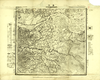
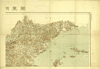
Image from the Map Collections courtesy Tohoku University. © 2023, the Committee for the Creation of the Gaihozu Digital Archives. 【図幅名】 【測量時期】 大正12年編纂 【発行時期】 大正13年発行 【記号】 関東州全図-右上 【測量機関】 關東廰・陸地測量部
リンク: 出所・参照情報
|
1924 | 2ヶ月 前 | 4個の基準点 |
|
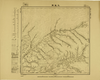
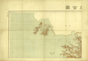
Image from the Map Collections courtesy Tohoku University. © 2023, the Committee for the Creation of the Gaihozu Digital Archives. 【図幅名】 【測量時期】 大正12年編纂 【発行時期】 大正13年発行 【記号】 関東州全図-左上 【測量機関】 關東廰・陸地測量部
リンク: 出所・参照情報
|
1924 | 2ヶ月 前 | 4個の基準点 |
|
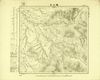
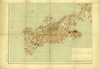
Image from the Map Collections courtesy Tohoku University. © 2023, the Committee for the Creation of the Gaihozu Digital Archives. 【図幅名】 【測量時期】 大正12年編纂 【発行時期】 大正13年発行 【記号】 関東州全図-左下 【測量機関】 關東廰・陸地測量部
リンク: 出所・参照情報
|
1924 | 2ヶ月 前 | 4個の基準点 |