Browse Maps
| map | Title | Year | Last Updated | Status  |
|---|---|---|---|---|
|
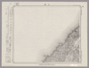
Image from the Map Collections courtesy Stanford University Libraries, licensed under a Creative Commons Attribution-Noncommercial 3.0 Unported License. © Stanford University. 【図幅名】 三瀬 【測量時期】 大正2年測図/昭和9年修正 【発行時期】 【記号】 酒田8号(共6面) 【測量機関】 参謀本部 【備考】 秘
Links: Source / Biblio Ref
|
about 2 years ago | 4 control points | |
|
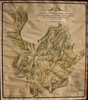
Image from the Map Collections courtesy Stanford University Libraries, licensed under a Creative Commons Attribution-Noncommercial 3.0 Unported License. © Stanford University. 【図幅名】 鳥海山 【測量時期】 大正2年測図/昭和9年修正 【発行時期】 昭和11年10月発行 【記号】 新庄14号(共16面) 【測量機関】 大日本帝国陸地測量部 【備考】
Links: Source / Biblio Ref
|
about 2 years ago | 4 control points | |
|
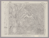
Image from the Map Collections courtesy Stanford University Libraries, licensed under a Creative Commons Attribution-Noncommercial 3.0 Unported License. © Stanford University. 【図幅名】 栗駒山 【測量時期】 大正2年測図/昭和9年修正 【発行時期】 【記号】 新庄3号(共16面) 【測量機関】 参謀本部 【備考】 秘
Links: Source / Biblio Ref
|
about 2 years ago | 4 control points | |
|
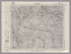
Image from the Map Collections courtesy Stanford University Libraries, licensed under a Creative Commons Attribution-Noncommercial 3.0 Unported License. © Stanford University. 【図幅名】 吉岡 【測量時期】 明治34年測図/昭和3年修正 【発行時期】 昭和6年10月発行 【記号】 仙台2号(共16面) 【測量機関】 大日本帝国陸地測量部 【備考】
Links: Source / Biblio Ref
|
about 2 years ago | 4 control points | |
|
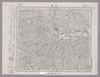
Image from the Map Collections courtesy Stanford University Libraries, licensed under a Creative Commons Attribution-Noncommercial 3.0 Unported License. © Stanford University. 【図幅名】 角田 【測量時期】 明治41年測図/昭和8年修正/昭和27年応急修正 【発行時期】 昭和35年7月発行 【記号】 福島1号(共18面) 【測量機関】 国土地理院 【備考】 応急修正版
Links: Source / Biblio Ref
|
about 2 years ago | 4 control points | |
|
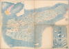
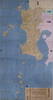
This geotiff map focused on south part of KyushuSatsuma and Osumi.
Type Pocket Map
Obj Height cm 68
Obj Width cm 166
Mounted cover title. Wood block print. In Japanese. Covers Matsumae to Tsushima and Ryukyu. Shows Ezo east from Kanto region. Shows distance of sea routes and main roads and kokudaka of daimyo. Includes legend. East Asian Library call number Ca 11.
Links: Source / Biblio Ref
|
1630 | almost 3 years ago | 16 control points |
|
【Courtesy of the C. V. Starr East Asian Library University of California, Berkeley】 Title on envelope: Saishin Wakayama-ken zenzu. In Japanese. Relief shown by hachures. Includes list of addresses and legend.
Links: Source / Biblio Ref
|
1908 | over 3 years ago | 4 control points |
|
Image from the Map Collections courtesy Stanford University Libraries, licensed under a Creative Commons Attribution-Noncommercial 3.0 Unported License. © Stanford University. 【図幅名】 若桜 【測量時期】 明治30年測図の縮図/明治31年測図/昭和7年修正 【発行時期】 昭和9年8月発行 【記号】 鳥取12号(共9面) 【測量機関】 大日本帝国陸地測量部 【備考】
Links: Source / Biblio Ref
|
about 2 years ago | 4 control points | |
|
【Courtesy of the C. V. Starr East Asian Library University of California, Berkeley】 In Japanese. Oriented with north to the upper left. Relief shown by hachures. Includes 5 insets and legend. Includes text on districts and distance chart on verso.
Links: Source / Biblio Ref
|
1903 | over 3 years ago | 4 control points |
|
【Courtesy of the C. V. Starr East Asian Library University of California, Berkeley】 Title on envelope: Saishin Ibaraki-ken zenzu. In Japanese. Relief shown by hachures. Includes list of addresses and legend.
Links: Source / Biblio Ref
|
1907 | over 3 years ago | 4 control points |

|
【Courtesy of the C. V. Starr East Asian Library University of California, Berkeley】 Lithograph. In Japanese. Oriented with north to the left. Relief shown by hachures. Includes 1 inset : Otsu shigai chizu. Includes distance charts and legend. Includes views of tourist attractions on verso.
Links: Source / Biblio Ref
|
1903 | over 3 years ago | 4 control points |
|
【Courtesy of the C. V. Starr East Asian Library University of California, Berkeley】 Mounted cover title. Title on map: Jichikubetsu kaisei Sado zenzu. Lithograph. In Japanese. Oriented with north to the upper right. Relief shown by hachures. Includes 3 insets and legend.
Links: Source / Biblio Ref
|
1894 | over 3 years ago | 4 control points |
|
【Courtesy of the C. V. Starr East Asian Library University of California, Berkeley】 Mounted cover title. In Japanese. Copperplate print. Relief shown by hachures. Title on map :Shiga-ken kannai chiri yakuzu. Includes legend.
Links: Source / Biblio Ref
|
1879 | over 3 years ago | 4 control points |
|
【Courtesy of the C. V. Starr East Asian Library University of California, Berkeley】 1 map : 81 x 167 cm., folded in cover 29 x 22 cm. Title added by hand. Wood block print. In Japanese. Covers Matsumae to Ryukyu and Tsushima. Shows points of interest pictorially. Includes lists of main shrines and place names, seasonal diagrams, distance charts and legend. Shows kokudaka. Relief shown pictorially. East Asian Library call number: Ca4.
Links: Source / Biblio Ref
|
1690 | almost 3 years ago | 11 control points |
|
【Courtesy of the C. V. Starr East Asian Library University of California, Berkeley】 Copperplate print. In Japanese. Relief shown by hachures. Includes legend.
Links: Source / Biblio Ref
|
1886 | over 3 years ago | 4 control points |
|
【Courtesy of the C. V. Starr East Asian Library University of California, Berkeley】 Title on envelope: Saishin Shizuoka-ken zenzu. In Japanese. Relief shown by hachures. Includes list of addresses and legend. Shows distance of sea routes.
Links: Source / Biblio Ref
|
1907 | over 3 years ago | 4 control points |
|
【Courtesy of the C. V. Starr East Asian Library University of California, Berkeley】 Title on enevelope: Saishin Miyagi-ken zenzu. In Japanese. Relief shown by hachures.
Links: Source / Biblio Ref
|
1907 | over 3 years ago | 4 control points |
|
【Courtesy of the C. V. Starr East Asian Library University of California, Berkeley】 Mounted cover title. Lithograph. Oriented with north to the upper right. In Japanese. Relief shown by gradient tint. Includes distance chart and legend.
Links: Source / Biblio Ref
|
1893 | over 3 years ago | 4 control points |
|
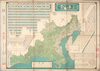
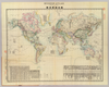
【Courtesy of the C. V. Starr East Asian Library University of California, Berkeley】 Mounted cover title. Col. copperplate print. In Japanese. Relief shown by hachures. Shows distance of sea routes. Includes text on earth, list of populations, national flags, and legend. Folded in cover 13 x 9 cm. East Asian Library call number: A18.
Links: Source / Biblio Ref
|
1873 | over 3 years ago | 4 control points |
|
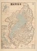
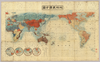
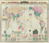
【Courtesy of the C. V. Starr East Asian Library University of California, Berkeley】 Col. wood block print. In Japanese. Includes texts on climate zones, latitudes and longitudes, and legend. Folded to 18 x 13 cm. East Asian Library call number: A4.
Links: Source / Biblio Ref
|
1850 | over 3 years ago | 4 control points |
|
【Courtesy of the C. V. Starr East Asian Library University of California, Berkeley】 In Japanese. Oriented with north to the upper right. Relief shown pictorially. Shows points of interest pictorially. Shows distance of sea routes. Includes 1 inset. Includes guide for tourist on verso. "Awaji Shinbun gogai.".
Links: Source / Biblio Ref
|
1903 | over 3 years ago | 4 control points |
|
【Courtesy of the C. V. Starr East Asian Library University of California, Berkeley】 Cover title. Title on map: Shiga-ken zenzu. Relief shown by hachures. Includes 3 insets and legend. Includes text on districts and list of addresses on verso. Drawn by Warajikai. In Japanese.
Links: Source / Biblio Ref
|
1911 | over 3 years ago | 4 control points |
|
|
2021 | almost 3 years ago | 3 control points |
|
|
2021 | over 2 years ago | 24 control points |
|
【Courtesy of the C. V. Starr East Asian Library University of California, Berkeley】 Colored manuscript map. Relief shown pictorially. Includes revisions. East Asian Library call number: MJ11.
Links: Source / Biblio Ref
|
1874 | over 3 years ago | 5 control points |
|
|
2021 | almost 3 years ago | 4 control points |
|
Image from the Map Collections courtesy Stanford University Libraries, licensed under a Creative Commons Attribution-Noncommercial 3.0 Unported License. © Stanford University. 【図幅名】 泊 【測量時期】 明治43年測図/昭和5年修正 【発行時期】 昭和9年5月発行 【記号】 富山7号(共11面) 【測量機関】 大日本帝国陸地測量部 【備考】 (In 1 layer)
Links: Source / Biblio Ref
|
about 2 years ago | 4 control points | |
|
Image from the Map Collections courtesy Stanford University Libraries, licensed under a Creative Commons Attribution-Noncommercial 3.0 Unported License. © Stanford University. 【図幅名】 針生 【測量時期】 大正2年測図/昭和8年要部修正 【発行時期】 昭和11年2月発行 【記号】 日光5号(共16面) 【測量機関】 大日本帝国陸地測量部 【備考】
Links: Source / Biblio Ref
|
about 2 years ago | 4 control points | |
|
【Courtesy of the C. V. Starr East Asian Library University of California, Berkeley】 Colored manuscript map. Relief shown pictorially. East Asian Library call number: MJ11.
Links: Source / Biblio Ref
|
1874 | over 2 years ago | 15 control points |
|
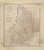
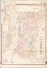
【Courtesy of the C. V. Starr East Asian Library University of California, Berkeley】 1 map : col. ; 112 x 75 cm., folded in cover 21 x 21 cm. In Japanese. Relief shown by contours and spot heights. Includes 2 insets and legend. East Asian Library call number: Cb120.1.
Links: Source / Biblio Ref
|
1894 | over 3 years ago | 4 control points |
|
|
2021 | almost 3 years ago | 4 control points |
|
Image from the Map Collections courtesy Stanford University Libraries, licensed under a Creative Commons Attribution-Noncommercial 3.0 Unported License. © Stanford University. 【図幅名】 播州赤穂 【測量時期】 明治28年測図/大正5年第2回修正/昭和24年応急修正 【発行時期】 昭和35年9月発行 【記号】 姫路12号(共16面) 【測量機関】 国土地理院 【備考】 応急修正版
Links: Source / Biblio Ref
|
about 2 years ago | 4 control points | |
|
Image from the Map Collections courtesy Stanford University Libraries, licensed under a Creative Commons Attribution-Noncommercial 3.0 Unported License. © Stanford University. 【図幅名】 米沢 【測量時期】 明治41年測図/昭和6年要部修正/昭和27年応急修正 【発行時期】 昭和28年3月発行 【記号】 福島13号(共18面) 【測量機関】 国土地理院 【備考】 応急修正版
Links: Source / Biblio Ref
|
about 2 years ago | 4 control points | |
|
【最初期発行】 この地図の作成に当たっては、国土地理院長の承認を得て、同院発行の20万分の1地勢図及び5万分の1地形図を使用した。(承認番号 平30情使、 第1148号) (In 1 layer)
Links: Source / Biblio Ref
|
1921 | 2 months ago | 4 control points |
|
【Courtesy of the C. V. Starr East Asian Library University of California, Berkeley】 Lithograph. In Japanese. Relief shown by hachures. Includes 3 insets and legend. Col. map folded to 24 x 13 cm. East Asian Library call number Bd5.
Links: Source / Biblio Ref
|
1895 | over 3 years ago | 4 control points |
|
【Courtesy of the C. V. Starr East Asian Library University of California, Berkeley】 1 map : col. ; 70 x 77 cm., folded in cover 19 x 14 cm. Mounted cover title. Title on map: Fujimi jusanshu yochi zenzu. Copper plate print. In Japanese. Relief shown pictorially. Includes legend. East Asian Library call number: D69.
Links: Source / Biblio Ref
|
1886 | over 3 years ago | 4 control points |
|
【Courtesy of the C. V. Starr East Asian Library University of California, Berkeley】 Col. map.
Links: Source / Biblio Ref
|
1895 | over 3 years ago | 4 control points |
|
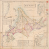
【Courtesy of the C. V. Starr East Asian Library University of California, Berkeley】 Col. map folded in cover 19 x 13 cm. Cover title. Title on map: Hokkaido zenzu. Copperplate print. In Japanese. Relief shown by hachures. Includes 3 insets, distance charts and legend. Shows the sea routes with distances. East Asian Library call number D26.
Links: Source / Biblio Ref
|
1902 | over 3 years ago | 4 control points |
|
【Courtesy of the C. V. Starr East Asian Library University of California, Berkeley】 Hand col. wood block print. In Japanese. Title from: Kyoto zu somokuroku / Otsuka Takashi. p.16. Relief shown pictorially. Includes distance chart and index. Includes text on main temples and shrines. Folded to 24 x 16 cm. East Asian Library call number: F3.
Links: Source / Biblio Ref
|
1696 | over 3 years ago | 4 control points |
|
【Courtesy of the C. V. Starr East Asian Library University of California, Berkeley】 Col. map folded in cover 18 x 13 cm. Mounted cover title. Title on map: Nihon ansha yakuzu : Hokkaido hokubu. Copperplate print. In Japanese. Relief shown by hachures. Includes 1 inset and legend. East Asian Library call number D6.
Links: Source / Biblio Ref
|
1879 | over 3 years ago | 4 control points |
|
【Courtesy of the C. V. Starr East Asian Library University of California, Berkeley】 Mounted cover title. Wood block print. In Japanese. Includes legend. Col., folded in cover. East Asian Library call number: A7.
Links: Source / Biblio Ref
|
1853 | over 3 years ago | 4 control points |
|
【Courtesy of the C. V. Starr East Asian Library University of California, Berkeley】 In Japanese. Relief shown by form lines. Includes fare table of boats and legend. "Tokyo Asahi Shinbun dai 4040-go furoku." Col. map, folded to 16 x 13 cm. East Asian Library call number Bd10.
Links: Source / Biblio Ref
|
1888 | over 3 years ago | 4 control points |
|
|
2021 | almost 3 years ago | 4 control points |
|
Image from the Map Collections courtesy Stanford University Libraries, licensed under a Creative Commons Attribution-Noncommercial 3.0 Unported License. © Stanford University. 【図幅名】 塩江 【測量時期】 明治31年測図/昭和7年修正 【発行時期】 昭和9年8月発行 【記号】 鳥取2号(共9面) 【測量機関】 大日本帝国陸地測量部 【備考】
Links: Source / Biblio Ref
|
about 2 years ago | 4 control points | |
|
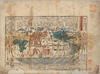
【Courtesy of the C. V. Starr East Asian Library University of California, Berkeley】 Engraved map. Relief shown pictorially. Inset maps: Kamtschatka. Door de Japonesers Genaamt, Oku Jeso, volgens de Nieuste Kaart van t'Russische Ryk -- Niphon of Noorderlyke Japanische Eilanden, en de Nabygelege Eilanden by Jesogasima ... Includes 2 inset illustrations, statistical tables and drawings of 3 figures: Tossitoku de Godt des Fortuyns by de Japonesen -- Iebis de Neptunus of Zeegodt der Japonesen -- Daikoku de Godt der Rykdomimen. Added in pen-and-ink: VIII. Tab. See p. 43-44 contents pages for fuller information. East Asian Library call number: 3409.9.2048.
Links: Source / Biblio Ref
|
1729 | over 3 years ago | 5 control points |
|
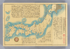
元禄9年(1696)作成、同15年(1702完成。約1/21,600。黒丸:一里塚。原図サイズ:東西414cmx 南北781cm。
Links: Source / Biblio Ref
|
1702 | almost 3 years ago | 22 control points |
|
【Courtesy of the C. V. Starr East Asian Library University of California, Berkeley】 Lithograph. In Japanese. Relief shown by hachures. Includes 2 insets: Akita-ken kannai riteizu.--Akita-shi. Includes legend. Includes text on Akita prefecture on verso.
Links: Source / Biblio Ref
|
1897 | over 3 years ago | 4 control points |
|
【Courtesy of the C. V. Starr East Asian Library University of California, Berkeley】 Cover title. In Japanese. Relief shown by hachures. Shows distance of sea routes. Includes lists of country names and time differentials and legend. Col., folded in cover 25 x 16 cm. East Asian Library call number: A48.
Links: Source / Biblio Ref
|
1889 | over 3 years ago | 4 control points |
|
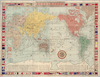
【Courtesy of the C. V. Starr East Asian Library University of California, Berkeley】 Cover title. Title on map: Yogo sonyu shintei bankoku yochi zenzu. Copperplate print. In Japanese and English. Relief shown by hachures. Shows distance of sea routes. Includes 21 insets, charts of mountains and rivers, and national flags. Includes distance chart of sea routes and legend. Col., folded in cover 22 x 15 cm. East Asian Library call number: A45.
Links: Source / Biblio Ref
|
1887 | over 3 years ago | 4 control points |
|
【Courtesy of the C. V. Starr East Asian Library University of California, Berkeley】 Copperplate print. In Japanese. Oriented with north to the right. Relief shown by hachures. Includes distance chart and legend.
Links: Source / Biblio Ref
|
1868 | over 3 years ago | 4 control points |