Browse Maps
| map | Title | Year | Last Updated | Status  |
|---|---|---|---|---|
|
Image from the Map Collections courtesy Stanford University Libraries, licensed under a Creative Commons Attribution-Noncommercial 3.0 Unported License. © Stanford University. 【図幅名】 大河原 【測量時期】 明治43年測図/昭和5年修正 【発行時期】 【記号】 甲府15号(共16面) 【測量機関】 参謀本部 【備考】 秘
Links: Source / Biblio Ref
|
2 months ago | 4 control points | |
|
|
2023 | over 1 year ago | 9 control points |
|
Image from the Map Collections courtesy Stanford University Libraries, licensed under a Creative Commons Attribution-Noncommercial 3.0 Unported License. © Stanford University. 【図幅名】 阿波富岡 【測量時期】 明治40年測図/昭和9年第2回修正、測図の縮図 【発行時期】 【記号】 剣山5号(共11面) 【測量機関】 陸地測量部 【備考】 秘
Links: Source / Biblio Ref
|
10 days ago | 4 control points | |
|
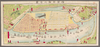
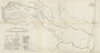
RIO MAGDALENA. PROTECCIÓN DE BARRANCA BERMEJA PARA ACOMPAÑAR AL INFORME DE SIR. A.GIBB G.B.C G.B. 14 DE JULIO DE 1930. PLANO Nº11
|
1930 | 11 months ago | 32 control points |
|
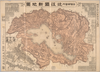
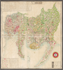
【Courtesy of the C. V. Starr East Asian Library University of California, Berkeley】 In Japanese. Oriented with north to the upper left. Relief shown by hachures. Includes 3 insets and legend. Includes distance chart and text on districts on verso.
Links: Source / Biblio Ref
|
1903 | over 3 years ago | 4 control points |
|
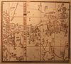
この地図の作成に当たっては、国土地理院長の承認を得て、同院発行の20万分の1地勢図及び5万分の1地形図を使用した。(承認番号 平30情使、 第1148号)
Links: Source / Biblio Ref
|
1946 | about 2 months ago | 4 control points |
|
Image from the Map Collections courtesy Stanford University Libraries, licensed under a Creative Commons Attribution-Noncommercial 3.0 Unported License. © Stanford University.
Links: Source / Biblio Ref
|
over 6 years ago | 4 control points | |

|
Links: Source / Biblio Ref
|
2020 | over 3 years ago | 4 control points |
|
Image from the Map Collections courtesy Stanford University Libraries, licensed under a Creative Commons Attribution-Noncommercial 3.0 Unported License. © Stanford University. 【図幅名】 和食 【測量時期】 明治40年測圖/昭和8年修正測圖 【発行時期】 【記号】 剣山九号 【測量機関】 参謀本部 【備考】 祕
Links: Source / Biblio Ref
|
10 days ago | 4 control points | |
|
この地図の作成に当たっては、国土地理院長の承認を得て、同院発行の20万分の1地勢図及び5万分の1地形図を使用した。(承認番号 平30情使、 第1148号)
Links: Source / Biblio Ref
|
1947 | over 1 year ago | 4 control points |
|
【Courtesy of the C. V. Starr East Asian Library University of California, Berkeley】 Oriented with north to the upper left. In Japanese. Relief shown by hachures. Includes 4 insets and legend. Includes text on districts and distance chart on verso.
Links: Source / Biblio Ref
|
1902 | over 1 year ago | 3 control points |
|
Image from the Map Collections courtesy Stanford University Libraries, licensed under a Creative Commons Attribution-Noncommercial 3.0 Unported License. © Stanford University. 【図幅名】 郡中 【測量時期】 明治36年測図の縮図/昭和3年修正、測図の縮図/昭和7年鉄道補入 【発行時期】 昭和9年4月発行 【記号】 松山6号(共15面) 【測量機関】 大日本帝国陸地測量部 【備考】 (In 1 layer)
Links: Source / Biblio Ref
|
2 months ago | 4 control points | |
|
Image from the Map Collections courtesy Stanford University Libraries, licensed under a Creative Commons Attribution-Noncommercial 3.0 Unported License. © Stanford University. 【図幅名】 ウトロ 【測量時期】 大正13年測圖/昭和11年部分修正測圖 【発行時期】 【記号】 網走四号 【測量機関】 参謀本部 【備考】 祕
Links: Source / Biblio Ref
|
over 2 years ago | 4 control points | |
|
Image from the Map Collections courtesy Stanford University Libraries, licensed under a Creative Commons Attribution-Noncommercial 3.0 Unported License. © Stanford University. 【図幅名】 大洲 【測量時期】 明治37年測図/昭和8年修正 【発行時期】 昭和11年7月発行 【記号】 松山7号(共15面) 【測量機関】 大日本帝国陸地測量部 【備考】 (In 1 layer)
Links: Source / Biblio Ref
|
2 months ago | 4 control points | |
|
Image from the Map Collections courtesy Stanford University Libraries, licensed under a Creative Commons Attribution-Noncommercial 3.0 Unported License. © Stanford University. 【図幅名】 熊川 【測量時期】 明治26年測図/大正9年修正 【発行時期】 【記号】 宮津4号(共5面) 【測量機関】 参謀本部 【備考】 秘
Links: Source / Biblio Ref
|
2 months ago | 4 control points | |
|
Image from the Map Collections courtesy Stanford University Libraries, licensed under a Creative Commons Attribution-Noncommercial 3.0 Unported License. © Stanford University. 【図幅名】 三瓶山 【測量時期】 明治32年測図/昭和7年修正 【発行時期】 昭和10年5月発行 【記号】 浜田6号(共15面) 【測量機関】 大日本帝国陸地測量部 【備考】
Links: Source / Biblio Ref
|
over 1 year ago | 4 control points | |
|
Links: Source / Biblio Ref
|
2021 | over 1 year ago | 4 control points |
|
|
2023 | over 1 year ago | 3 control points |
|
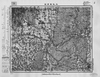
京都府立京都学・歴彩館所蔵
上京区地籍図
Links: Source / Biblio Ref
|
1884 | over 6 years ago | 4 control points |
|
Image from the Map Collections courtesy Stanford University Libraries, licensed under a Creative Commons Attribution-Noncommercial 3.0 Unported License. © Stanford University. 【図幅名】 赤名 【測量時期】 明治32年測圖/昭和7年修正測圖 【発行時期】 【記号】 浜田七号 【測量機関】 参謀本部 【備考】 祕
Links: Source / Biblio Ref
|
over 1 year ago | 4 control points | |
|
【Courtesy of the C. V. Starr East Asian Library University of California, Berkeley】 Mounted cover title. Title on map: Fukui-ken kannai chizu. Wood block print. In Japanese. Relief shown by hachures.
Links: Source / Biblio Ref
|
1883 | over 3 years ago | 4 control points |
|
shelfmark: Maps 149.e.230
License: Public Domain
江戸後期写 Manuscript, early 19th century. Acquired 22 July 1868. Ex-Siebold.
Links: Source / Biblio Ref
|
over 1 year ago | 4 control points | |
|
|
2020 | almost 4 years ago | 8 control points |
|
shelfmark: Maps 38.c.216
License: Public Domain
天保14 *無刊記。外題「(富士見十三州)輿地之全図」。江戸湾に「御台場」なし。凡例末を入れ木して「故名焉」と改む。 Xylograph.
Links: Source / Biblio Ref
|
1843 | over 2 years ago | 22 control points |
|
【Courtesy of the C. V. Starr East Asian Library University of California, Berkeley】 Lithograph. Relief shown by hachures. Includes 3 insets and legend. Includes distance chart and text on districts on verso. In Japanese.
Links: Source / Biblio Ref
|
1909 | over 3 years ago | 4 control points |
|
shelfmark: Maps 24.b.212
License: Public Domain
江戸後期写 *浜松助郷村名等を明記す。藩政用の図力。 Manuscript, early 19th century.
Links: Source / Biblio Ref
|
over 3 years ago | 14 control points | |
|
Image from the Map Collections courtesy Stanford University Libraries, licensed under a Creative Commons Attribution-Noncommercial 3.0 Unported License. © Stanford University. 【図幅名】 斜里 【測量時期】 大正13年測圖/昭和19年部分修正測圖 【発行時期】 【記号】 斜里五号 【測量機関】 参謀本部 【備考】 軍事祕密(戦地ニ限リ極祕) (In 1 layer)
Links: Source / Biblio Ref
|
over 2 years ago | 4 control points | |
|
shelfmark: Maps 9.b.25
License: Public Domain
天保14 *多色刷り。無刊記。外題「(富士見十三州)輿地之全図」。凡例末を入れ木して「故名焉」と改む。 Xylograph
Links: Source / Biblio Ref
|
1843 | over 3 years ago | 13 control points |
|
Image from the Map Collections courtesy Stanford University Libraries, licensed under a Creative Commons Attribution-Noncommercial 3.0 Unported License. © Stanford University. 【図幅名】 【測量時期】 【発行時期】 【記号】 【測量機関】 【備考】 (In 1 layer)
Links: Source / Biblio Ref
|
over 2 years ago | 4 control points | |
|
Image from the Map Collections courtesy Stanford University Libraries. This item is in the public domain. There are no restrictions on use.
【図幅名】 武魯頓灣 【測量時期】 大正5年測圖 【発行時期】昭和11年 【記号】 新知島七号 【測量機関】 参謀本部 【その他】千島列島 陸地測量部 (In 1 layer)
Links: Source / Biblio Ref
|
1936 | about 1 year ago | 14 control points |
|
Image from the Map Collections courtesy Stanford University Libraries, licensed under a Creative Commons Attribution-Noncommercial 3.0 Unported License. © Stanford University. 【図幅名】 苫前 【測量時期】 大正11年測図/昭和8年鉄道補入 【発行時期】 昭和10年5月発行 【記号】 羽幌7号(共8面) 【測量機関】 大日本帝国陸地測量部 【備考】 仮製版
Links: Source / Biblio Ref
|
almost 6 years ago | 4 control points | |
|
shelfmark: Or.75.f.11
License: Public Domain
貞享4 *ケンペル旧蔵。 Xylograph. Ex-Kaempfer. Gardner #563. Kurita 17.
Links: Source / Biblio Ref
|
1687 | over 3 years ago | 22 control points |
|
Image from the Map Collections courtesy Stanford University Libraries, licensed under a Creative Commons Attribution-Noncommercial 3.0 Unported License. © Stanford University. 【図幅名】 仁位 【測量時期】 大正1年測図/大正11年測図の縮図/昭和10年修正、第2回修正、測図の縮図 【発行時期】 昭和21年11月発行 【記号】 厳原10号(共7面) 【測量機関】 地理調査所 【備考】
Links: Source / Biblio Ref
|
about 2 months ago | 4 control points | |
|
shelfmark: Maps 149.e.23
License: Public Domain
江戸後期写 Manuscript, early 19th century. Acquired 22 July 1868. Ex-Siebold.
Links: Source / Biblio Ref
|
over 2 years ago | 8 control points | |
|
Links: Source / Biblio Ref
|
1851 | over 6 years ago | 4 control points |
|
shelfmark: Maps 63100.5
License: Public Domain
明治10 *多色刷り。 Xylograph.
Links: Source / Biblio Ref
|
1877 | over 3 years ago | 14 control points |
|
Image from the Map Collections courtesy Stanford University Libraries, licensed under a Creative Commons Attribution-Noncommercial 3.0 Unported License. © Stanford University. 【図幅名】 今庄 【測量時期】 明治25年測図/明治42年測図の縮図/昭和7年第2回修正、測図の縮図 【発行時期】 昭和9年12月発行 【記号】 岐阜14号(共16面) 【測量機関】 大日本帝国陸地測量部 【備考】 (In 1 layer)
Links: Source / Biblio Ref
|
3 months ago | 4 control points | |
|
shelfmark: Maps 63100.4
License: Public Domain
明治10 *多色刷り。刊記に「明治六年八月官許/明治十年二月刻成」とあり。 Xylograph. Acquired 22 July 1868. Ex-Siebold.
Links: Source / Biblio Ref
|
1877 | over 3 years ago | 9 control points |
|
|
2022 | over 2 years ago | 8 control points |
|
shelfmark: Maps 63145.11
License: Public Domain
明治3 *多色刷り。外題「横浜明細全図」。 Manuscript copied in the early 19th century. Purchased from Martinus Nijhof, The Hague, 8 November 1893.
Links: Source / Biblio Ref
|
1870 | over 3 years ago | 7 control points |
|
Links: Source / Biblio Ref
|
almost 4 years ago | 4 control points | |
|
Croquis de los rios Napo y Putumayo. Geografía Militar del Perú. NOTA: Este croquis ha sido reconstruido por JORGE MARTINEZ L. y MANUEL JOSE PEÑA C.I.C con los datos, croquis y planos publicados por el Coronel Pedro Portillo en diferentes épocas; los señor Rafael E. Baluarte en 1905; los del señor Camilo Vallejos Z. en 1907, y el croquis del señor Victor Macedo que acompaña la obra EN EL PUTUMAYO Y SUS AFLUENTES, por Eugenio Robuchon. Concluido el trabajo de reconstrucción, ha sido confronttado con los informes del Ingeniero alemán von Hassel, sobre los VARADEROS o ARRASTRADEROS, y con los originales o cartera de ingeniero de Robuchon, que por muchos años se consideraron perdidos, pero ellos fueron facilitados al autor de GEOGRAFIA MILITAR DEL PERU, por el doctor Santiago Rozo. OBSEQUIO DE LA FABRICA DE LICORES Y PERFUMES DE CUNDINAMARCA
|
1930 | 11 months ago | 9 control points |
|
【Courtesy of the C. V. Starr East Asian Library University of California, Berkeley】 Mounted cover title. In Japanese. Copperplate print. Relief shown by hachures. Includes preface and legend.
Links: Source / Biblio Ref
|
1878 | over 3 years ago | 4 control points |
|
|
2023 | over 1 year ago | 13 control points |
|
Image from the Map Collections courtesy Stanford University Libraries, licensed under a Creative Commons Attribution-Noncommercial 3.0 Unported License. © Stanford University. 【図幅名】 【測量時期】 【発行時期】 【記号】 【測量機関】 【備考】
Links: Source / Biblio Ref
|
about 1 month ago | 4 control points | |
|
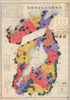
Gráfico para mostrar la densidad de la población y el volumen del tráfico anual en las distintas vías fluviales, ferrocarriles y cables en la REPUBLICA DE COLOMBIA. Corresponde a los datos del año 1923. Konsortium de Julius Berger. Agosto 1924
|
1928 | 11 months ago | 12 control points |
|
【Courtesy of the C. V. Starr East Asian Library University of California, Berkeley】 Lithograph. In Japanese. Relief shown by hachures. Includes 4 insets and legend.
Links: Source / Biblio Ref
|
1868 | over 3 years ago | 4 control points |
|
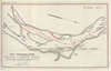
PLANO DEL RIO MAGDALENA QUE MUESTRA LA ZONA DE INUNDACION Y LOS LIMITES DEL CLIMA. JBK
|
1928 | 11 months ago | 14 control points |
|
|
1864 | over 6 years ago | 3 control points |
|
Mapa de la Región Hidrográfica del Amazonas Peruano CON SUS AFLUENTES NAVEGABLES. Mandado trazar por la SOCIEDAD GEOGRAFICA DE LIMA. Por MAX DOIG. PRIMER MAPA. OBSEQUI DE LA FABRICA DE LICORES Y PERFUMES DE CUNDINAMARCA
|
1930 | 11 months ago | 12 control points |