Browse Maps
| map | Title | Year | Last Updated | Status  |
|---|---|---|---|---|
|
|
2023 | about 1 year ago | 4 control points |
|
Image from the Map Collections courtesy Stanford University Libraries, licensed under a Creative Commons Attribution-Noncommercial 3.0 Unported License. © Stanford University. 【図幅名】 仁位 【測量時期】 大正1年測図/大正11年測図の縮図/昭和10年修正、第2回修正、測図の縮図 【発行時期】 昭和21年11月発行 【記号】 厳原10号(共7面) 【測量機関】 地理調査所 【備考】
Links: Source / Biblio Ref
|
over 5 years ago | 4 control points | |
|
|
2023 | about 1 year ago | 4 control points |
|
Image from the Map Collections courtesy Stanford University Libraries, licensed under a Creative Commons Attribution-Noncommercial 3.0 Unported License. © Stanford University. 【図幅名】 【測量時期】 【発行時期】 【記号】 【測量機関】 【備考】 (In 1 layer)
Links: Source / Biblio Ref
|
about 2 years ago | 4 control points | |
|
|
2023 | about 1 year ago | 5 control points |
|
Image from the Map Collections courtesy Stanford University Libraries, licensed under a Creative Commons Attribution-Noncommercial 3.0 Unported License. © Stanford University. 【図幅名】 大河原 【測量時期】 明治43年測図/昭和5年修正 【発行時期】 【記号】 甲府15号(共16面) 【測量機関】 参謀本部 【備考】 秘
Links: Source / Biblio Ref
|
about 2 years ago | 4 control points | |
|
Image from the Map Collections courtesy Stanford University Libraries. This item is in the public domain. There are no restrictions on use.
【図幅名】 新知嶽 【測量時期】 大正5年測圖 【発行時期】昭和11年 【記号】 新知島十二号 【測量機関】 参謀本部 【その他】千島列島 陸地測量部 (In 1 layer)
Links: Source / Biblio Ref
|
1936 | over 1 year ago | 4 control points |
|
【Courtesy of the C. V. Starr East Asian Library University of California, Berkeley】 Mounted cover title. In Japanese. Copperplate print. Relief shown by hachures. Includes preface and legend.
Links: Source / Biblio Ref
|
1878 | over 3 years ago | 4 control points |
|
|
2023 | about 1 year ago | 5 control points |
|
【Courtesy of the C. V. Starr East Asian Library University of California, Berkeley】 Lithograph. In Japanese. Relief shown by hachures. Includes 4 insets and legend.
Links: Source / Biblio Ref
|
1868 | over 3 years ago | 4 control points |
|
Image from the Map Collections courtesy Stanford University Libraries. This item is in the public domain. There are no restrictions on use.
【図幅名】 計吐夷島 【測量時期】 大正6年測圖 【発行時期】昭和11年 【記号】 羅処和島八号、十二号、新知島一号【測量機関】 参謀本部 【その他】千島列島 陸地測量部 (In 1 layer)
Links: Source / Biblio Ref
|
1936 | over 1 year ago | 4 control points |
|
Image from the Map Collections courtesy Stanford University Libraries, licensed under a Creative Commons Attribution-Noncommercial 3.0 Unported License. © Stanford University.
Links: Source / Biblio Ref
|
over 6 years ago | 4 control points | |
|
Public Domain. © Stanford University.
【図幅名】 松山南部 【記号】松山近傍8号(共12面)
Links: Source / Biblio Ref
|
about 2 months ago | 4 control points | |
|
大正6年千葉県告示第四十二号
|
1917 | over 3 years ago | 3 control points |
|
|
2023 | about 1 year ago | 5 control points |
|
|
2018 | over 6 years ago | 4 control points |
|
|
2023 | about 1 year ago | 5 control points |
|
Links: Source / Biblio Ref
|
over 3 years ago | 4 control points | |
|
|
2023 | about 1 year ago | 5 control points |
|
この地図の作成に当たっては、国土地理院長の承認を得て、同院発行の20万分の1地勢図及び5万分の1地形図を使用した。(承認番号 平30情使、 第1148号)
Links: Source / Biblio Ref
|
1946 | over 5 years ago | 4 control points |
|
|
2023 | about 1 year ago | 5 control points |
|
|
2022 | about 2 years ago | 8 control points |
|
|
2023 | about 1 year ago | 5 control points |
|
Image from the Map Collections courtesy Stanford University Libraries, licensed under a Creative Commons Attribution-Noncommercial 3.0 Unported License. © Stanford University. 【図幅名】 恩根内 【測量時期】 大正12年測図 【発行時期】 大正13年10月発行 【記号】 名寄9号(共16面) 【測量機関】 大日本帝国陸地測量部 【備考】 仮製版 (In 1 layer)
Links: Source / Biblio Ref
|
about 2 years ago | 4 control points | |
|
|
2023 | about 1 year ago | 5 control points |
|
Image from the Map Collections courtesy Stanford University Libraries, licensed under a Creative Commons Attribution-Noncommercial 3.0 Unported License. © Stanford University. 【図幅名】 鴻ノ舞 【測量時期】 大正12年、大正13年測図/昭和3年鉄道補入 【発行時期】 昭和5年3月発行 【記号】 紋別12号(共11面) 【測量機関】 大日本帝国陸地測量部 【備考】 仮製版
Links: Source / Biblio Ref
|
about 2 years ago | 4 control points | |
|
|
2023 | about 1 year ago | 5 control points |
|
【最初期発行】 この地図の作成に当たっては、国土地理院長の承認を得て、同院発行の20万分の1地勢図及び5万分の1地形図を使用した。(承認番号 平30情使、 第1148号) (In 1 layer)
Links: Source / Biblio Ref
|
1916 | about 4 years ago | 4 control points |
|
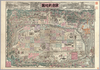
【Courtesy of the C. V. Starr East Asian Library University of California, Berkeley】 Japanese date Meiji 33 1900. In color. Folded. Title on envelope: Kyōto meisai shinzu. Lithograph. In Japanese. Oriented with north to the left. Relief shown pictorially. Includes distance chart, a list of local products in Kyōto. Shows views of tourist attractions.
Links: Source / Biblio Ref
|
1900 | over 3 years ago | 4 control points |
|
【Courtesy of the C. V. Starr East Asian Library University of California, Berkeley】 Oriented with north to the upper right. Mounted cover title. Copperplate print. In Japanese. Title on map: Kaisei Mie-ken chizu. Relief shown by hachures. Includes 6 insets and legend. Shows distance of roads.
Links: Source / Biblio Ref
|
1890 | over 3 years ago | 4 control points |
|
ルート3
|
2023 | 8 months ago | 7 control points |
|
Links: Source / Biblio Ref
|
2021 | over 1 year ago | 8 control points |
|
Image from the Map Collections courtesy Stanford University Libraries, licensed under a Creative Commons Attribution-Noncommercial 3.0 Unported License. © Stanford University. 【図幅名】 桑名 【測量時期】 明治24年測図の縮図/昭和7年第2回修正、測図の縮図 【発行時期】 昭和9年12月発行 【記号】 名古屋6号(共16面) 【測量機関】 大日本帝国陸地測量部 【備考】
Links: Source / Biblio Ref
|
4 months ago | 4 control points | |
|
Image from the Map Collections courtesy Stanford University Libraries, licensed under a Creative Commons Attribution-Noncommercial 3.0 Unported License. © Stanford University. 【図幅名】 阿波富岡 【測量時期】 明治40年測図/昭和9年第2回修正、測図の縮図 【発行時期】 【記号】 剣山5号(共11面) 【測量機関】 陸地測量部 【備考】 秘
Links: Source / Biblio Ref
|
about 2 years ago | 4 control points | |
|
|
2023 | about 1 year ago | 5 control points |
|
|
2022 | about 2 years ago | 3 control points |
|
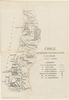
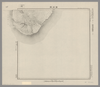
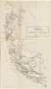
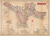
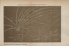
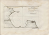
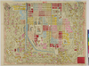
El “Mapa de las líneas marítimas”, un plegable que Julio Parga Polanía incluyó en su Guía del comercio de Bogotá, publicada en 1904 por la Imprenta de El Nuevo Tiempo. El autor se destacó por dirigir una variada colección de publicación de vocación comerciales, entre guías de ciudades de Colombia y publicaciones periodísticas como El Pabellón y El Ciclón. El mapa traza parte de la costa atlántica colombiana, desde Cartagena hasta la península de La Guajira, centrando su interés en Puerto Colombia, renovada terminal marítima de Barranquilla inaugurada en 1893. En tal sentido el documento tuvo la intención de persuadir al lector de la guía para enseñar las posibilidades de transporte marítimo. A través de 11 rutas que conectaron al muelle con distintos puertos de la Europa Occidental, de las Antillas, de México y de E.E.U.U.
Links: Source / Biblio Ref
|
2020 | over 1 year ago | 6 control points |
|
【Courtesy of the C. V. Starr East Asian Library University of California, Berkeley】 Mounted cover title. Copperplate print. In Japanese. Oriented with north to the lower left. Relief shown by hachures. Includes legend.
Links: Source / Biblio Ref
|
1889 | over 3 years ago | 4 control points |
|
|
2023 | about 1 year ago | 5 control points |
|
Image from the Map Collections courtesy Stanford University Libraries, licensed under a Creative Commons Attribution-Noncommercial 3.0 Unported License. © Stanford University. 【図幅名】 松江 【測量時期】 明治32年測図/昭和9年第2回修正、測図の縮図 【発行時期】 昭和12年4月発行 【記号】 松江16号(共8面) 【測量機関】 大日本帝国陸地測量部 【備考】
Links: Source / Biblio Ref
|
about 2 years ago | 4 control points | |
|
Links: Source / Biblio Ref
|
2020 | about 1 year ago | 4 control points |
|
Image from the Map Collections courtesy Stanford University Libraries, licensed under a Creative Commons Attribution-Noncommercial 3.0 Unported License. © Stanford University. 【図幅名】 高遠 【測量時期】 明治43年測図/昭和6年要部修正 【発行時期】 【記号】 甲府13号(共16面) 【測量機関】 参謀本部 【備考】 秘
Links: Source / Biblio Ref
|
about 2 years ago | 4 control points | |
|
|
2023 | about 1 year ago | 5 control points |
|
Image from the Map Collections courtesy Stanford University Libraries, licensed under a Creative Commons Attribution-Noncommercial 3.0 Unported License. © Stanford University.
Links: Source / Biblio Ref
|
over 6 years ago | 4 control points | |
|
|
2023 | about 1 year ago | 5 control points |
|
|
2022 | almost 2 years ago | 5 control points |
|
From Nurlan
|
2023 | over 1 year ago | 4 control points |
|
|
2018 | over 6 years ago | 3 control points |
|
|
2023 | about 1 year ago | 5 control points |
|
|
2020 | over 3 years ago | 8 control points |