Browse Maps
| map | Title | Year | Last Updated | Status  |
|---|---|---|---|---|
|
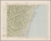
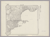
Image from the Map Collections courtesy Stanford University Libraries, licensed under a Creative Commons Attribution-Noncommercial 3.0 Unported License. © Stanford University. 【図幅名】 馬緤 【測量時期】 明治43年測図/昭和9年修正 【発行時期】 昭和22年3月発行 【記号】 珠洲岬15号(共4面) 【測量機関】 内務省地理調査所 【備考】
Links: Source / Biblio Ref
|
about 2 years ago | 4 control points | |
|
この地図の作成に当たっては、国土地理院長の承認を得て、同院発行の20万分の1地勢図及び5万分の1地形図を使用した。(承認番号 平30情使、 第1148号)
Links: Source / Biblio Ref
|
1946 | over 5 years ago | 4 control points |
|
Image from the Map Collections courtesy Stanford University Libraries, licensed under a Creative Commons Attribution-Noncommercial 3.0 Unported License. © Stanford University.
Links: Source / Biblio Ref
|
over 6 years ago | 4 control points | |
|
この地図の作成に当たっては、国土地理院長の承認を得て、同院発行の20万分の1地勢図及び5万分の1地形図を使用した。(承認番号 平30情使、 第1148号)
Links: Source / Biblio Ref
|
1946 | over 5 years ago | 4 control points |
|
Image from the Map Collections courtesy Stanford University Libraries, licensed under a Creative Commons Attribution-Noncommercial 3.0 Unported License. © Stanford University. 【図幅名】 須木 【測量時期】 明治35年測圖/昭和7年要部修正測圖/昭和10年部分修正測圖 【発行時期】 【記号】 延岡十六号 【測量機関】 参謀本部 【備考】 祕
Links: Source / Biblio Ref
|
about 4 years ago | 4 control points | |
|
この地図の作成に当たっては、国土地理院長の承認を得て、同院発行の20万分の1地勢図及び5万分の1地形図を使用した。(承認番号 平30情使、 第1148号)
Links: Source / Biblio Ref
|
1946 | over 5 years ago | 4 control points |
|
Image from the Map Collections courtesy Stanford University Libraries, licensed under a Creative Commons Attribution-Noncommercial 3.0 Unported License. © Stanford University. 【図幅名】 船津 【測量時期】 大正1年測図/昭和5年部分修正 【発行時期】 昭和8年1月発行 【記号】 高山11号(共16面) 【測量機関】 大日本帝国陸地測量部 【備考】
Links: Source / Biblio Ref
|
about 2 years ago | 4 control points | |
|
Image from the Map Collections courtesy Stanford University Libraries, licensed under a Creative Commons Attribution-Noncommercial 3.0 Unported License. © Stanford University. 【図幅名】 西表島西南部 【測量時期】 大正10年測図 【発行時期】 大正12年発行 【記号】 先島群島18号 【測量機関】 陸地測量部・参謀本部 【備考】 西表島7号
Links: Source / Biblio Ref
|
over 4 years ago | 4 control points | |
|
Image from the Map Collections courtesy Stanford University Libraries, licensed under a Creative Commons Attribution-Noncommercial 3.0 Unported License. © Stanford University. 【図幅名】 竹生島 【測量時期】 明治26年測図/大正9年修正/昭和7年鉄道補入/昭和26年応急修正 【発行時期】 昭和29年9月発行 【記号】 岐阜16号(共16面) 【測量機関】 国土地理院 【備考】 応急修正版 (In 1 layer)
Links: Source / Biblio Ref
|
about 2 years ago | 4 control points | |
|
Image from the Map Collections courtesy Stanford University Libraries, licensed under a Creative Commons Attribution-Noncommercial 3.0 Unported License. © Stanford University. 【図幅名】 西表島西北部 【測量時期】 大正10年測図 【発行時期】 大正12年発行 【記号】 先島群島17号 【測量機関】 陸地測量部・参謀本部 【備考】 西表島6号
Links: Source / Biblio Ref
|
over 4 years ago | 4 control points | |
|
|
2018 | over 6 years ago | 4 control points |
|
Image from the Map Collections courtesy Stanford University Libraries, licensed under a Creative Commons Attribution-Noncommercial 3.0 Unported License. © Stanford University.
Links: Source / Biblio Ref
|
over 5 years ago | 4 control points | |
|
Image from the Map Collections courtesy Stanford University Libraries, licensed under a Creative Commons Attribution-Noncommercial 3.0 Unported License. © Stanford University.
Links: Source / Biblio Ref
|
over 6 years ago | 4 control points | |
|
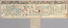
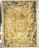
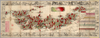
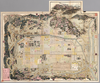
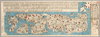
【Courtesy of the C. V. Starr East Asian Library University of California, Berkeley】 Description 1 map : col. ; on sheet 133 x 228 cm., folded in cover 34 x 20 cm. Mounted cover title. Wood block print. In Japanese. Covers Matsumae to Tsushima, Okinoerabu, and Hachijojima. Shows Kuroshio and distance of sea routes and main roads. Includes legend. Text by Shoto Sanjin and preface by Shino Odo. East Asian Library call number Ca 17.
Links: Source / Biblio Ref
|
1808 | over 2 years ago | 19 control points |
|
Image from the Map Collections courtesy Stanford University Libraries, licensed under a Creative Commons Attribution-Noncommercial 3.0 Unported License. © Stanford University. 【図幅名】 徳佐中 【測量時期】 明治32年測図/昭和7年要部修正 【発行時期】 昭和9年10月発行 【記号】 山口6号(共15面) 【測量機関】 大日本帝国陸地測量部 【備考】
Links: Source / Biblio Ref
|
about 2 years ago | 4 control points | |
|
【Courtesy of the C. V. Starr East Asian Library University of California, Berkeley】 Japanese date Meiji 23 1890. In color. Folded. Mounted cover title. Copperplate print. In Japanese. Includes 2 insets, fare table of trains and legend. Shows views of tourist attractions. Relief shown pictorially. Shows distances of roads and sea routes.
Links: Source / Biblio Ref
|
1890 | over 3 years ago | 5 control points |
|
Links: Source / Biblio Ref
|
2020 | about 1 year ago | 4 control points |
|
【最初期発行】 この地図の作成に当たっては、国土地理院長の承認を得て、同院発行の20万分の1地勢図及び5万分の1地形図を使用した。(承認番号 平30情使、 第1148号)
Links: Source / Biblio Ref
|
1935 | over 5 years ago | 4 control points |
|
この地図の作成に当たっては、国土地理院長の承認を得て、同院発行の20万分の1地勢図及び5万分の1地形図を使用した。(承認番号 平30情使、 第1148号)
Links: Source / Biblio Ref
|
1947 | over 5 years ago | 4 control points |
|
【最初期発行】 この地図の作成に当たっては、国土地理院長の承認を得て、同院発行の20万分の1地勢図及び5万分の1地形図を使用した。(承認番号 平30情使、 第1148号)
Links: Source / Biblio Ref
|
1913 | over 5 years ago | 4 control points |
|
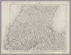
Image from the Map Collections courtesy Stanford University Libraries, licensed under a Creative Commons Attribution-Noncommercial 3.0 Unported License. © Stanford University. 【図幅名】 厚岸 【測量時期】 大正11年測図 【発行時期】 昭和11年11月発行 【記号】 根室近傍8号(共11面) 【測量機関】 参謀本部・陸地測量部 【備考】 釧路2号(共12面) 仮製版 (In 1 layer)
Links: Source / Biblio Ref
|
about 2 years ago | 4 control points | |
|
【最初期発行】 この地図の作成に当たっては、国土地理院長の承認を得て、同院発行の20万分の1地勢図及び5万分の1地形図を使用した。(承認番号 平30情使、 第1148号)
Links: Source / Biblio Ref
|
1911 | over 5 years ago | 4 control points |
|
【Courtesy of the C. V. Starr East Asian Library University of California, Berkeley】 Col. map folded in cover 14 x 9 cm. Copperplate print. In Japanese. Oriented with north to the left. Includes distance chart and legend. "Hakodate shinbun dai kyuhyakunanajunigo hatsuzuri furoku." East Asian Library call number D9.
Links: Source / Biblio Ref
|
1884 | over 3 years ago | 4 control points |
|
【最初期発行】 この地図の作成に当たっては、国土地理院長の承認を得て、同院発行の20万分の1地勢図及び5万分の1地形図を使用した。(承認番号 平30情使、 第1148号)
Links: Source / Biblio Ref
|
1913 | over 5 years ago | 4 control points |
|
Image from the Map Collections courtesy Stanford University Libraries, licensed under a Creative Commons Attribution-Noncommercial 3.0 Unported License. © Stanford University. 【図幅名】 霧多布 【測量時期】 大正11年測図 【発行時期】 昭和11年11月発行 【記号】 根室近傍7号(共11面) 【測量機関】 参謀本部・陸地測量部 【備考】 根室14号(共5面) 仮製版 軍事極秘 (In 1 layer)
Links: Source / Biblio Ref
|
over 5 years ago | 4 control points | |
|
この地図の作成に当たっては、国土地理院長の承認を得て、同院発行の20万分の1地勢図及び5万分の1地形図を使用した。(承認番号 平30情使、 第1148号)
Links: Source / Biblio Ref
|
1923 | over 5 years ago | 4 control points |

|
Image from the Map Collections courtesy Stanford University Libraries, licensed under a Creative Commons Attribution-Noncommercial 3.0 Unported License. © Stanford University. 【図幅名】 寿都 【測量時期】 大正6年測圖/昭和3年鐡道補入 【発行時期】 【記号】 岩内十六号 【測量機関】 参謀本部 【備考】 祕 (In 1 layer)
Links: Source / Biblio Ref
|
about 2 years ago | 4 control points | |
|
Image from the Map Collections courtesy Stanford University Libraries, licensed under a Creative Commons Attribution-Noncommercial 3.0 Unported License. © Stanford University. 【図幅名】 鯖江 【測量時期】 明治42年測図/昭和5年修正/昭和8年要部修正 【発行時期】 昭和8年7月発行 【記号】 岐阜13号(共16面) 【測量機関】 大日本帝国陸地測量部 【備考】 (In 1 layer)
Links: Source / Biblio Ref
|
about 2 years ago | 4 control points | |
|
|
1813 | about 7 years ago | 15 control points |
|
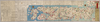
【Courtesy of the C. V. Starr East Asian Library University of California, Berkeley】 Japanese date Meiji 13 1880. In color. Folded. Mounted cover title. Copperplate print. In Japanese. Relief shown pictorially. Shows distance of roads and sea routes. Includes legend.
Links: Source / Biblio Ref
|
1880 | about 3 years ago | 6 control points |
|
Image from the Map Collections courtesy Stanford University Libraries, licensed under a Creative Commons Attribution-Noncommercial 3.0 Unported License. © Stanford University. 【図幅名】 男女群島北部 【測量時期】 明治44年測圖/昭和11年要部修正測圖 【発行時期】 【記号】 富江十二号 【測量機関】 参謀本部 【備考】 祕
Links: Source / Biblio Ref
|
about 4 years ago | 4 control points | |
|
【Courtesy of the C. V. Starr East Asian Library University of California, Berkeley】 Japanese date Genji 1 1864. In color. Folded. Mounted cover title. Wood block print. Oriented with north to the left. In Japanese. Relief shown pictorially. Includes legend.
Links: Source / Biblio Ref
|
1864 | over 3 years ago | 4 control points |
|
Image from the Map Collections courtesy Stanford University Libraries, licensed under a Creative Commons Attribution-Noncommercial 3.0 Unported License. © Stanford University. 【図幅名】 佐須余 【測量時期】 大正11年測図の縮図/昭和10年修正、測図の縮図 【発行時期】 昭和21年11月発行 【記号】 厳原9号(共7面) 【測量機関】 内務省地理調査所 【備考】
Links: Source / Biblio Ref
|
about 4 years ago | 4 control points | |
|
【Courtesy of the C. V. Starr East Asian Library University of California, Berkeley】 Japanese date Meiji 23 1890. In color. Folded. Copperplate print. In Japanese. Bird's-eye view. Includes list of city names and 1 inset. Shows views of tourist attractions.
Links: Source / Biblio Ref
|
1890 | over 3 years ago | 5 control points |
|
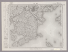
Image from the Map Collections courtesy Stanford University Libraries, licensed under a Creative Commons Attribution-Noncommercial 3.0 Unported License. © Stanford University. 【図幅名】 相川 【測量時期】 大正2年測図/昭和9年修正 【発行時期】 【記号】 相川12号(共3面) 【測量機関】 参謀本部 【備考】 秘
Links: Source / Biblio Ref
|
about 2 years ago | 4 control points | |
|
【Courtesy of the C. V. Starr East Asian Library University of California, Berkeley】 Japanese date Meiji 11 1878. In color. Folded. Copperplate print. In Japanese. Oriented with north to the upper right. Relief shown pictorially. Shows distance of roads and sea routes. Includes distance chart, list of inns and shrines, and legend.
Links: Source / Biblio Ref
|
1878 | over 3 years ago | 5 control points |
|
Image from the Map Collections courtesy Stanford University Libraries, licensed under a Creative Commons Attribution-Noncommercial 3.0 Unported License. © Stanford University. 【図幅名】 福山 【測量時期】 明治31年測図/大正14年第2回修正 【発行時期】 【記号】 岡山及丸亀10号(共14面) 【測量機関】 参謀本部 【備考】 秘
Links: Source / Biblio Ref
|
3 months ago | 4 control points | |
|
【Courtesy of the C. V. Starr East Asian Library University of California, Berkeley】 Japanese date Meiji 26 1893. In color. Folded. Cover title. Lithograph print. In Japanese. Oriented with north to the left. Relief shown pictorially. Includes distance chart and legend. Extension pasted on the top of map.
Links: Source / Biblio Ref
|
1893 | over 5 years ago | 4 control points |
|
Image from the Map Collections courtesy Stanford University Libraries, licensed under a Creative Commons Attribution-Noncommercial 3.0 Unported License. © Stanford University. 【図幅名】 玉庭 【測量時期】 大正2年測図/昭和6年要部修正 【発行時期】 昭和8年10月発行 【記号】 新潟1号(共16面) 【測量機関】 大日本帝国陸地測量部 【備考】
Links: Source / Biblio Ref
|
about 2 years ago | 4 control points | |
|
【Courtesy of the C. V. Starr East Asian Library University of California, Berkeley】 Japanese date Meiji 23 1890. Folded. Copperplate print. In Japanese. Relief shown pictorially. Includes distance chart and legend. Shows views of tourist attractions.
Links: Source / Biblio Ref
|
1890 | over 3 years ago | 4 control points |
|
この地図の作成に当たっては、国土地理院長の承認を得て、同院発行の20万分の1地勢図及び5万分の1地形図を使用した。(承認番号 平30情使、 第1148号)
Links: Source / Biblio Ref
|
1947 | over 5 years ago | 4 control points |
|
【Courtesy of the C. V. Starr East Asian Library University of California, Berkeley】 Japanese date Meiji 11 1878. In color. Folded. Mounted cover title. Copperplate print. In Japanese. Relief shown pictorially. Shows distance of roads. Includes list of inns and legend.
Links: Source / Biblio Ref
|
1878 | over 3 years ago | 5 control points |
|
Image from the Map Collections courtesy Stanford University Libraries, licensed under a Creative Commons Attribution-Noncommercial 3.0 Unported License. © Stanford University. 【図幅名】 竹貫 【測量時期】 明治41年測図/昭和8年要部修正 【発行時期】 昭和11年5月発行 【記号】 白河6号(共17面) 【測量機関】 大日本帝国陸地測量部 【備考】
Links: Source / Biblio Ref
|
about 2 years ago | 4 control points | |
|
この地図の作成に当たっては、国土地理院長の承認を得て、同院発行の20万分の1地勢図及び5万分の1地形図を使用した。(承認番号 平30情使、 第1148号)
Links: Source / Biblio Ref
|
1953 | over 5 years ago | 4 control points |
|
Links: Source / Biblio Ref
|
2020 | about 1 year ago | 4 control points |
|
Links: Source / Biblio Ref
|
2020 | over 1 year ago | 8 control points |
|
|
2022 | almost 2 years ago | 8 control points |
|
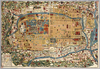
【Courtesy of the C. V. Starr East Asian Library University of California, Berkeley】 Japanese date Keiō 2 1866. In color. Folded. Title from: Kyōto zu sōmokuroku /Ōtsuka Takashi. p.66. Wood block print. In Japanese. Relief shown pictorially. Includes distance charts, text, and legend. Local Note EAST; F 55: Title added by hand :Kyō saiken ezu. Monted cover title is missing Subject
Links: Source / Biblio Ref
|
1866 | over 3 years ago | 4 control points |
|
【Courtesy of the C. V. Starr East Asian Library University of California, Berkeley】 Mounted cover title. Copperplate print. Relief shown by hachures. In Japanese. Includes legend and 1 inset. Title on map: Nihon chishiryaku yakuzu : sono san. Col. map folded in cover 18 x 13 cm. East Asian Library call number Cb38.
Links: Source / Biblio Ref
|
1876 | over 3 years ago | 4 control points |
|
【Courtesy of the C. V. Starr East Asian Library University of California, Berkeley】 Japanese date Keiō 3 1867. In color. Folded. Mounted cover title. Wood block print. In Japanese. Title added by hand. Includes kokudaka and crests of daimyo and legend. Okuyama Seiei kōzu. Orientation varies.
Links: Source / Biblio Ref
|
1867 | over 3 years ago | 5 control points |