Browse Maps
| map | Title | Year | Last Updated | Status  |
|---|---|---|---|---|
|
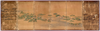
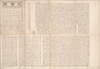
【Courtesy of the C. V. Starr East Asian Library University of California, Berkeley】 Manuscript. In Japanese. On verso: Tokaido gojusantsugi zu. Mounted as a screen. Includes 2 ancillary maps and a calandar. East Asian Library call number: Byobu 1 SPEC-Map. 2 maps : ms., col. ; on sheets 71 x 230 cm.
Links: Source / Biblio Ref
|
1640 | over 5 years ago | Unrectified |
|
Links: Source / Biblio Ref
|
2020 | almost 4 years ago | Unrectified |
|
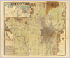
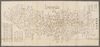
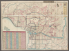
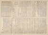
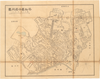
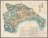
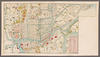
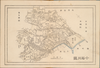
【Courtesy of the C. V. Starr East Asian Library University of California, Berkeley】 In Japanese. Relief shown by hachures. 5 insets: Kyoto-fu kannaizu.--Maizuru minatomachi kaichikuzu.--Miyazu-cho.--Fushimi-cho.--Fukuchiyama-cho. Includes distance chart and legend. Folded to 26 x 16 cm. Col. East Asian Library call number: F132,
Links: Source / Biblio Ref
|
1902 | over 5 years ago | Unrectified |
|
shelfmark: Maps 63140.15
License: Public Domain
明治9 *多色刷り。銅板。 Xylograph. Beans 40.
Links: Source / Biblio Ref
|
1876 | over 4 years ago | Unrectified |
|
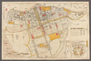
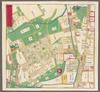
【Courtesy of the C. V. Starr East Asian Library University of California, Berkeley】 Lithograph. In Japanese. Oriented with north to the upper left. Relief shown by hachures. Includes 4 insets and legend. Includes distance chart and text on districts on verso.
Links: Source / Biblio Ref
|
1895 | over 5 years ago | Unrectified |
|
shelfmark: Maps 63135.3
License: Public Domain
江戸後期 *手彩色。無題図。「相川御役所」の記載あり。 Xylograph.
Links: Source / Biblio Ref
|
over 4 years ago | Unrectified | |
|
shelfmark: Maps 63100.14
License: Public Domain
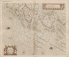
嘉永1 *多色刷り。図名は下記の同版図による。無刊記。樗園長山貫序、平塚知郷題。 Xylograph. Ex-Kaempfer. Gardner #566.
Links: Source / Biblio Ref
|
1848 | over 4 years ago | Unrectified |
|
【Courtesy of the C. V. Starr East Asian Library University of California, Berkeley】 Manuscript. In Japanese. On verso: Tokaido gojusantsugi zu. Mounted as a screen. Includes 2 ancillary maps and a calandar. East Asian Library call number: Byobu 1 SPEC-Map. 2 maps : ms., col. ; on sheets 71 x 230 cm.
Links: Source / Biblio Ref
|
1640 | over 5 years ago | Unrectified |

|
shelfmark: Maps 62980.19
License: Public Domain
嘉永7 *多色刷り。刊記「東都浅草玉樹軒蔵梓」。刊年及び蔵版者は附図による。結城甘泉序。 Xylograph. Acquired 22 July 1868 Siebold. The colophon claims that the blocks were revised monthly.
Links: Source / Biblio Ref
|
1854 | over 4 years ago | Unrectified |
|
shelfmark: Maps *63100.22
License: Public Domain
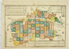
江戸中期 *外題「(増補改正)河内細見図」。刊記に「改正河内屋喜兵衛」とあり。 Xylograph. Acquired 22 July 1868. Ex-Siebold.
Links: Source / Biblio Ref
|
1776 | over 4 years ago | Unrectified |
|
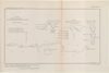
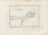
【Courtesy of the C. V. Starr East Asian Library University of California, Berkeley】 Copperplate print. In Japanese. Oriented with north to the upper left. Bird's-eye view. Harbors--Japan--Yokosuka-shi--Maps. Yokosuka-shi Japan--Maps.
Links: Source / Biblio Ref
|
1882 | over 5 years ago | Unrectified |
|
shelfmark: Maps 63140.17
License: Public Domain
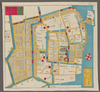
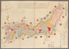
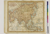
文久1 *多色刷り。『江戸切絵図集成』第四巻所収の文久1訂・図 図に該当。外題「京橋南築地絵図」。 Copperplate. Includes Hokkaido, Karafuto i.e., Sakhalin, the Chishima archipelago i.e., Kurile Islands and the Ryukyu islands i.e., Okinawa Prefecture.
Links: Source / Biblio Ref
|
1861 | over 4 years ago | Unrectified |
|
shelfmark: Maps *63035.1
License: Public Domain
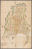
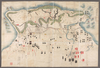
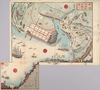
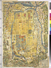
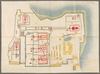
寛政4 *手彩色。図題左方に「寛永十五年二月二十八日落城備図」とあり。奥書「黒田家士斉藤五六郎定備ヨリ借写/天明五乙巳歳三月大屋/寛政四壬子歳二月写瀬名貞雄[幕臣、奥右筆組頭。寛政8<1796>歿]」。蔵書印「柳峰□蔵書記」。 Xylograph. Acquired 22 July 1868. Ex-Siebold.
Links: Source / Biblio Ref
|
1792 | over 4 years ago | Unrectified |
|
|
1930 | 7 months ago | 5 control points |
|
Links: Source / Biblio Ref
|
2020 | almost 4 years ago | Unrectified |
|
shelfmark: Maps 63145.12
License: Public Domain
明治4 *多色刷り。 Xylograph.
Links: Source / Biblio Ref
|
1871 | over 4 years ago | Unrectified |
|
Links: Source / Biblio Ref
|
2020 | almost 4 years ago | Unrectified |

|
【Courtesy of the C. V. Starr East Asian Library University of California, Berkeley】 In Japanese. Relief shown by hachures. Includes 4 insets and legend. Includes distance chart and texts on districts on verso.
Links: Source / Biblio Ref
|
1901 | over 5 years ago | Unrectified |
|
shelfmark: Maps 63140.14
License: Public Domain
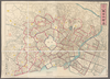
明治初期 *多色刷り。銅板。外題「改正東京御絵図」。無刊記。英字ペン書書入れあり。 Copperplate.
Links: Source / Biblio Ref
|
over 4 years ago | Unrectified | |
|
Links: Source / Biblio Ref
|
2020 | almost 4 years ago | Unrectified |

|
|
2018 | over 6 years ago | Unrectified |
|
|
7 months ago | 1 control point | |
|
gisday2019
|
1912 | over 5 years ago | Unrectified |
|
shelfmark: Maps 63400.1
License: Public Domain
嘉永6 *多色刷り。刊記に「鈴亭森田桑蔵板」とあり。無書肆名。 Xylograph; not identical to previous entry. Ex-Kaemprer. Gardner #567.
Links: Source / Biblio Ref
|
1853 | over 4 years ago | Unrectified |
|
【Courtesy of the C. V. Starr East Asian Library University of California, Berkeley】 Manuscript. In Japanese. On verso: Tokaido gojusantsugi zu. Mounted as a screen. Includes 2 ancillary maps and a calandar. East Asian Library call number: Byobu 1 SPEC-Map. 2 maps : ms., col. ; on sheets 71 x 230 cm
Links: Source / Biblio Ref
|
1640 | over 5 years ago | Unrectified |
|
Links: Source / Biblio Ref
|
2020 | almost 4 years ago | Unrectified |
|
参謀本部陸地測量部1/50000地形図
|
1918 | over 3 years ago | 2 control points |
|
|
|
2019 | over 5 years ago | Unrectified |
|
shelfmark: Maps 63140.7
License: Public Domain
江戸中期 *二色刷り、手彩色。無刊記。附「隅田河木母寺旧跡」。「永代島新築地」等、修訂の箇所多し。「万石以上本所御上屋敷分」に一名のみ(津軽土佐守[=津軽信寿弘前藩五代藩主か])、後は空白。 Copperplate.
Links: Source / Biblio Ref
|
over 4 years ago | Unrectified | |
|
【Courtesy of the C. V. Starr East Asian Library University of California, Berkeley】 Lithograph. In Japanese. Oriented with north to the left. Relief shown by hachures. Includes 1 inset : Otsu shigai chizu. Includes distance charts and legend. Includes views of tourist attractions on verso.
Links: Source / Biblio Ref
|
1903 | over 5 years ago | Unrectified |
|
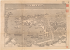
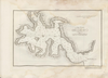
【Courtesy of the C. V. Starr East Asian Library University of California, Berkeley】 Cover title. Title on map: Mie-ken Shima no Kuni annaizu. Oriented with north to the upper right. In Japanese. Relief shown by hachures. Shows views of points of interest. Includes text on districts on verso. Includes distance chart and legend.
Links: Source / Biblio Ref
|
1903 | over 5 years ago | Unrectified |
|
|
7 months ago | 10 control points | |
|
【Courtesy of the C. V. Starr East Asian Library University of California, Berkeley】 Mounted cover title. Wood block print. In Japanese. Title on map: Yokohama onkaichi meisai no zu. Oriented with north to the lower right. Includes legend. Relief shown pictorially. Extension pasted on the bottom left of map.
Links: Source / Biblio Ref
|
1859 | over 5 years ago | Unrectified |
|
【Courtesy of the C. V. Starr East Asian Library University of California, Berkeley】 Manuscript. In Japanese. On verso: Tokaido gojusantsugi zu. Mounted as a screen. Includes 2 ancillary maps and a calandar. East Asian Library call number: Byobu 1 SPEC-Map. 2 maps : ms., col. ; on sheets 71 x 230 cm.
Links: Source / Biblio Ref
|
1640 | over 5 years ago | Unrectified |
|
【Courtesy of the C. V. Starr East Asian Library University of California, Berkeley】 Copperplate print. In Japanese. Orientation varies. Relief shown by hachures.
Links: Source / Biblio Ref
|
1900 | over 5 years ago | Unrectified |
|
|
2018 | over 6 years ago | 2 control points |
|
shelfmark: Maps 63100.23
License: Public Domain
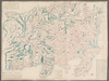
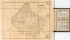
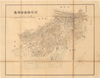
江戸後期 *外題「相模国全図」。多色刷り。(刊記書肆)書林/京都、菊屋七郎兵衛/大坂、河内屋喜兵衛・河内屋茂兵衛/江戸、須原屋茂兵衛・須原屋佐助・須原屋伊八・岡田屋嘉七・英大助・小林新兵衛・山城屋佐兵衛・菊屋幸三郎板。 Xylograph.
Links: Source / Biblio Ref
|
over 4 years ago | Unrectified | |
|
Links: Source / Biblio Ref
|
2020 | almost 4 years ago | Unrectified |
|
shelfmark: Maps 63140.18
License: Public Domain
文久2 *多色刷り。『江戸切絵図集成』第五巻所収文久2刊図に該当。 Copperplate.
Links: Source / Biblio Ref
|
1862 | over 4 years ago | Unrectified |
|
shelfmark: Maps *63165.1
License: Public Domain
嘉永1 *多色刷り。無刊記。 Xylograph. Acquired 13 July 1903.
Links: Source / Biblio Ref
|
1848 | over 4 years ago | Unrectified |
|
shelfmark: Maps 63165.4
License: Public Domain
江戸後期 *手彩色。「御書物蔵」等明記。 Xylograph. Acquired 20 December 1878.
Links: Source / Biblio Ref
|
over 4 years ago | Unrectified | |
|
shelfmark: Maps *63155.2
License: Public Domain
江戸後期 *多色刷り。 Xylograph. Acquired 21 December 1878. Beans 1.33; Yamashita 58; Mody, plate 38.
Links: Source / Biblio Ref
|
over 4 years ago | Unrectified | |
|
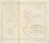
【Courtesy of the C. V. Starr East Asian Library University of California, Berkeley】 Copperplate print. In Japanese. Oriented with north to the upper right. Relief shown by hachures. Includes text on verso and legend. Drawn by Fuse Yoshio.
Links: Source / Biblio Ref
|
1898 | over 5 years ago | Unrectified |
|
【Courtesy of the C. V. Starr East Asian Library University of California, Berkeley】 Copperplate print. In Japanese. Orientation varies. Relief shown by hachures.
Links: Source / Biblio Ref
|
1900 | over 5 years ago | Unrectified |
|
【Courtesy of the C. V. Starr East Asian Library University of California, Berkeley】 Cover title. Copperplate print. In Japanese. Orientation varies. Relief shown by hachures. Includes address chart, text and legend.
Links: Source / Biblio Ref
|
1900 | over 5 years ago | Unrectified |
|
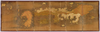
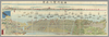
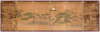
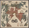
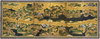
【Courtesy of the C. V. Starr East Asian Library University of California, Berkeley】 1 map : ms., col. ; 94 x 532 cm., folded to 106 x 48 cm. Manuscript. In Japanese. Panorama. Mounted as a screen. Orientation varies. East Asian Library call number: Byobu 2 SPEC-Map.
Links: Source / Biblio Ref
|
1600 | over 5 years ago | Unrectified |
|
Owned by 立命館大学アート・リサーチセンター 【成立・出版年】
Links: Source / Biblio Ref
|
almost 6 years ago | Unrectified | |
|
【Courtesy of the C. V. Starr East Asian Library University of California, Berkeley】 Copperplate print. In Japanese. Orientation varies. Relief shown by hachures.
Links: Source / Biblio Ref
|
1900 | over 5 years ago | Unrectified |
|
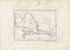
【Courtesy of the C. V. Starr East Asian Library University of California, Berkeley】 Cover title. In Japanese. Oriented with north to the upper left. Relief shown by hachures. Includes legend. Shows distance of sea routes. Includes list of district names on verso.
Links: Source / Biblio Ref
|
1904 | over 5 years ago | Unrectified |
|
|
7 months ago | 1 control point |