Browse Maps
| map | Title | Year | Last Updated | Status  |
|---|---|---|---|---|
|
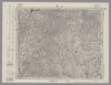
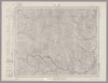
Image from the Map Collections courtesy Stanford University Libraries, licensed under a Creative Commons Attribution-Noncommercial 3.0 Unported License. © Stanford University. 【図幅名】 生野 【測量時期】 明治30年測図/昭和7年要部修正 【発行時期】 【記号】 姫路2号(共16面) 【測量機関】 参謀本部 【備考】 秘
Links: Source / Biblio Ref
|
about 1 month ago | 4 control points | |
|
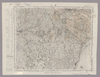
Image from the Map Collections courtesy Stanford University Libraries, licensed under a Creative Commons Attribution-Noncommercial 3.0 Unported License. © Stanford University. 【図幅名】 掛川 【測量時期】 明治22年測図/大正5年第2回修正/昭和5年鉄道補入 【発行時期】 昭和7年2月発行 【記号】 静岡16号(共15面) 【測量機関】 大日本帝国陸地測量部 【備考】
Links: Source / Biblio Ref
|
2 months ago | 4 control points | |
|
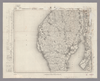
Image from the Map Collections courtesy Stanford University Libraries, licensed under a Creative Commons Attribution-Noncommercial 3.0 Unported License. © Stanford University. 【図幅名】 半田 【測量時期】 明治23年測図/大正9年修正、測図の縮図/昭和7年鉄道補入、測図の縮図 【発行時期】 昭和10年5月発行 【記号】 名古屋3号(共16面) 【測量機関】 大日本帝国陸地測量部 【備考】
Links: Source / Biblio Ref
|
2 months ago | 4 control points | |
|
|
2022 | about 2 years ago | 6 control points |
|
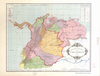
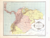
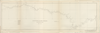
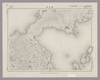
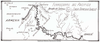
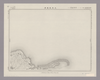
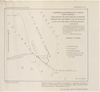
RIO MAGDALENA. PROTECCIÓN DE PUERTO WILCHES PARA ACOMPAÑAR AL INFORME DE SIR. A.GIBB G.B.C G.B. 14 DE JULIO DE 1930. PLANO Nº3
|
1930 | 11 months ago | 32 control points |
|
|
2022 | about 2 years ago | 4 control points |
|
Image from the Map Collections courtesy Stanford University Libraries, licensed under a Creative Commons Attribution-Noncommercial 3.0 Unported License. © Stanford University. 【図幅名】 掛塚 【測量時期】 明治22年測図縮図/昭和13年第2回修正、測図の縮図 【発行時期】 昭和15年3月発行 【記号】 伊良湖岬1号(共3面) 【測量機関】 大日本帝国陸地測量部 【備考】
Links: Source / Biblio Ref
|
2 months ago | 4 control points | |
|
Image from the Map Collections courtesy Stanford University Libraries, licensed under a Creative Commons Attribution-Noncommercial 3.0 Unported License. © Stanford University. 【図幅名】 津和野 【測量時期】 明治32年測図/昭和7年要部修正 【発行時期】 昭和9年9月発行 【記号】 山口2号(共15面) 【測量機関】 大日本帝国陸地測量部 【備考】
Links: Source / Biblio Ref
|
over 2 years ago | 13 control points | |
|
Links: Source / Biblio Ref
|
over 2 years ago | 4 control points | |
|
Image from the Map Collections courtesy Stanford University Libraries, licensed under a Creative Commons Attribution-Noncommercial 3.0 Unported License. © Stanford University. 【図幅名】 山口 【測量時期】 明治32年測図の縮図/昭和2年修正、測図の縮図/昭和15年修正、測図の縮図 【発行時期】 昭和16年4月発行 【記号】 山口11号(共15面) 【測量機関】 大日本帝国陸地測量部 【備考】
Links: Source / Biblio Ref
|
over 2 years ago | 4 control points | |
|
Image from the Map Collections courtesy Stanford University Libraries, licensed under a Creative Commons Attribution-Noncommercial 3.0 Unported License. © Stanford University. 【図幅名】 大台ケ原山 【測量時期】 明治44年測図/昭和6年要部修正 【発行時期】 昭和7年6月発行 【記号】 宇治山田15号(共14面) 【測量機関】 大日本帝国陸地測量部 【備考】
Links: Source / Biblio Ref
|
2 months ago | 4 control points | |
|
Image from the Map Collections courtesy Stanford University Libraries, licensed under a Creative Commons Attribution-Noncommercial 3.0 Unported License. © Stanford University. 【図幅名】 久和 【測量時期】 大正1年測図の縮図/昭和10年第2回修正、測図の縮図 【発行時期】 昭和21年10月発行 【記号】 厳原12号(共7面) 【測量機関】 内務省地理調査所 【備考】
Links: Source / Biblio Ref
|
about 1 month ago | 4 control points | |
|
Image from the Map Collections courtesy Stanford University Libraries, licensed under a Creative Commons Attribution-Noncommercial 3.0 Unported License. © Stanford University. 【図幅名】 盧辺 【測量時期】 大正12年測図の縮図/昭和10年修正、測図の縮図 【発行時期】 昭和21年11月発行 【記号】 唐津2号(共8面) 【測量機関】 内務省地理調査所 【備考】
Links: Source / Biblio Ref
|
about 1 month ago | 4 control points | |
|
Image from the Map Collections courtesy Stanford University Libraries, licensed under a Creative Commons Attribution-Noncommercial 3.0 Unported License. © Stanford University. 【図幅名】 伊島 【測量時期】 明治40年測図/昭和9年修正 【発行時期】 昭和11年6月発行 【記号】 由良要塞近傍8号(共10面) 【測量機関】 陸地測量部 【備考】 剣山1号(共12面) 軍事極秘
Links: Source / Biblio Ref
|
3 days ago | 4 control points | |
|
Owned by 立命館大学アート・リサーチセンター 【成立・出版年】 明治121879
Links: Source / Biblio Ref
|
1879 | over 5 years ago | 75 control points |

|
Image from the Map Collections courtesy Stanford University Libraries, licensed under a Creative Commons Attribution-Noncommercial 3.0 Unported License. © Stanford University. 【図幅名】 防府 【測量時期】 明治32年測図/昭和2年修正 【発行時期】 昭和13年7月発行 【記号】 山口8号(共15面) 【測量機関】 大日本帝国陸地測量部 【備考】
Links: Source / Biblio Ref
|
about 1 month ago | 4 control points | |
|
Links: Source / Biblio Ref
|
2020 | about 4 years ago | 8 control points |
|
Image from the Map Collections courtesy Stanford University Libraries, licensed under a Creative Commons Attribution-Noncommercial 3.0 Unported License. © Stanford University. 【図幅名】 【測量時期】 【発行時期】 【記号】 【測量機関】 【備考】
Links: Source / Biblio Ref
|
about 1 month ago | 4 control points | |
|
Links: Source / Biblio Ref
|
2020 | almost 3 years ago | 5 control points |
|
Links: Source / Biblio Ref
|
2020 | almost 3 years ago | 5 control points |
|
(In 1 layer)
Links: Source / Biblio Ref
|
1924 | over 1 year ago | 4 control points |
|
Image from the Map Collections courtesy Stanford University Libraries, licensed under a Creative Commons Attribution-Noncommercial 3.0 Unported License. © Stanford University. 【図幅名】 豊岡 【測量時期】 明治36年測圖/昭和2年要部修正測圖 【発行時期】 【記号】 中津十二号 【測量機関】 参謀本部 【備考】 祕
Links: Source / Biblio Ref
|
22 days ago | 4 control points | |
|
Image from the Map Collections courtesy Stanford University Libraries, licensed under a Creative Commons Attribution-Noncommercial 3.0 Unported License. © Stanford University. 【図幅名】 熊田 【測量時期】 明治36年測圖/昭和7年要部修正測圖 【発行時期】 【記号】 大分八号 【測量機関】 参謀本部 【備考】 祕
Links: Source / Biblio Ref
|
30 days ago | 4 control points | |
|
Image from the Map Collections courtesy Stanford University Libraries, licensed under a Creative Commons Attribution-Noncommercial 3.0 Unported License. © Stanford University. 【図幅名】 村所 【測量時期】 明治35年測図/昭和10年要部修正、部分修正 【発行時期】 昭和21年11月発行 【記号】 延岡15号(共13面) 【測量機関】 地理調査所 【備考】
Links: Source / Biblio Ref
|
about 1 month ago | 4 control points | |
|
Image from the Map Collections courtesy Stanford University Libraries, licensed under a Creative Commons Attribution-Noncommercial 3.0 Unported License. © Stanford University. 【図幅名】 高鍋 【測量時期】 明治35年測図/昭和7年要部修正/昭和10年部分修正 【発行時期】 【記号】 延岡8号(共13面) 【測量機関】 参謀本部 【備考】 秘
Links: Source / Biblio Ref
|
about 1 month ago | 4 control points | |
|
|
11 months ago | 3 control points | |
|
Image from the Map Collections courtesy Stanford University Libraries, licensed under a Creative Commons Attribution-Noncommercial 3.0 Unported License. © Stanford University. 【図幅名】 嘉手納 【測量時期】 大正10年測圖 【発行時期】 大正12年発行 【記号】 沖縄郡島十一号 【測量機関】 陸地測量部・参謀本部 【備考】 軍事極祕(戦地ニ在りテハ軍事祕密トス)
Links: Source / Biblio Ref
|
2 months ago | 4 control points | |
|
Image from the Map Collections courtesy Stanford University Libraries, licensed under a Creative Commons Attribution-Noncommercial 3.0 Unported License. © Stanford University. 【図幅名】 平島 【測量時期】 昭和5年測圖(海上寫眞測量) 【発行時期】 昭和11年発行 【記号】 奄美大島要塞近傍二号 【測量機関】 陸地測量部・参謀本部 【備考】 軍事極祕(戦地ニ在りテハ軍事祕密トス) 假製版
Links: Source / Biblio Ref
|
about 2 months ago | 4 control points | |
|
|
2022 | over 1 year ago | 5 control points |
|
Image from the Map Collections courtesy Stanford University Libraries, licensed under a Creative Commons Attribution-Noncommercial 3.0 Unported License. © Stanford University. 【図幅名】 那覇 【測量時期】 大正10年測圖 【発行時期】 大正12年発行 【記号】 沖縄郡島十五号 【測量機関】 陸地測量部・参謀本部 【備考】 軍事極祕(戦地ニ在りテハ軍事祕密トス)
Links: Source / Biblio Ref
|
2 months ago | 4 control points | |
|
この地図の作成に当たっては、国土地理院長の承認を得て、同院発行の20万分の1地勢図及び5万分の1地形図を使用した。(承認番号 平30情使、 第1148号)
Links: Source / Biblio Ref
|
1946 | over 5 years ago | 4 control points |
|
この地図の作成に当たっては、国土地理院長の承認を得て、同院発行の20万分の1地勢図及び5万分の1地形図を使用した。(承認番号 平30情使、 第1148号)
Links: Source / Biblio Ref
|
1946 | over 5 years ago | 4 control points |
|
【最初期発行】 この地図の作成に当たっては、国土地理院長の承認を得て、同院発行の20万分の1地勢図及び5万分の1地形図を使用した。(承認番号 平30情使、 第1148号)
Links: Source / Biblio Ref
|
1911 | over 5 years ago | 4 control points |
|
この地図の作成に当たっては、国土地理院長の承認を得て、同院発行の20万分の1地勢図及び5万分の1地形図を使用した。(承認番号 平30情使、 第1148号)
Links: Source / Biblio Ref
|
1946 | over 5 years ago | 4 control points |
|
(In 1 layer)
Links: Source / Biblio Ref
|
1924 | over 1 year ago | 4 control points |

|
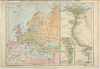
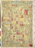
【Courtesy of the C. V. Starr East Asian Library University of California, Berkeley】 Japanese date Tenpō 10 1839. In color. Folded. Title from lining paper. Wood block print. Covers Ezo to Tsushima. Includes lists of messenger fees and legend. Engraved by Fujiki Teishichirō.
Links: Source / Biblio Ref
|
1839 | almost 4 years ago | 5 control points |
|
Image from the Map Collections courtesy Stanford University Libraries, licensed under a Creative Commons Attribution-Noncommercial 3.0 Unported License. © Stanford University.
Links: Source / Biblio Ref
|
almost 6 years ago | 4 control points | |
|
この地図の作成に当たっては、国土地理院長の承認を得て、同院発行の20万分の1地勢図及び5万分の1地形図を使用した。(承認番号 平30情使、 第1148号)
Links: Source / Biblio Ref
|
1946 | over 5 years ago | 4 control points |
|
(In 1 layer)
Links: Source / Biblio Ref
|
2020 | over 1 year ago | 6 control points |
|
Image from the Map Collections courtesy Stanford University Libraries, licensed under a Creative Commons Attribution-Noncommercial 3.0 Unported License. © Stanford University. 【図幅名】 島原 【測量時期】 明治33年測圖/大正15年修正測圖/昭和7年要部修正測圖 【発行時期】 昭和9年発行 【記号】 熊本十二号 【測量機関】 大日本帝國陸地測量部 【備考】
Links: Source / Biblio Ref
|
30 days ago | 4 control points | |
|
Image from the Map Collections courtesy Stanford University Libraries, licensed under a Creative Commons Attribution-Noncommercial 3.0 Unported License. © Stanford University. 【図幅名】 内之浦 【測量時期】 明治34年測図/昭和7年要部修正/昭和10年部分修正 【発行時期】 【記号】 開聞岳1号東部(共7面) 【測量機関】 参謀本部 【備考】 秘
Links: Source / Biblio Ref
|
about 1 month ago | 4 control points | |
|
Image from the Map Collections courtesy Stanford University Libraries, licensed under a Creative Commons Attribution-Noncommercial 3.0 Unported License. © Stanford University. 【図幅名】 久米島南部 【測量時期】 大正10年測圖 【発行時期】 昭和11年発行 【記号】 沖縄郡島二十三号 【測量機関】 陸地測量部・参謀本部 【備考】 軍事極祕(戦地ニ在りテハ軍事祕密トス)
Links: Source / Biblio Ref
|
2 months ago | 4 control points | |
|
Image from the Map Collections courtesy Stanford University Libraries, licensed under a Creative Commons Attribution-Noncommercial 3.0 Unported License. © Stanford University. 【図幅名】 久米島東部 【測量時期】 大正10年測圖 【発行時期】 昭和11年発行 【記号】 沖縄郡島二十二号 【測量機関】 陸地測量部・参謀本部 【備考】 軍事極祕(戦地ニ在りテハ軍事祕密トス)
Links: Source / Biblio Ref
|
2 months ago | 4 control points | |
|
Image from the Map Collections courtesy Stanford University Libraries, licensed under a Creative Commons Attribution-Noncommercial 3.0 Unported License. © Stanford University. 【図幅名】 魚貫崎 【測量時期】 明治34年測圖/昭和7年要部修正測圖 【発行時期】 【記号】 野母崎三号 【測量機関】 参謀本部 【備考】 祕
Links: Source / Biblio Ref
|
about 1 month ago | 4 control points | |
|
Image from the Map Collections courtesy Stanford University Libraries, licensed under a Creative Commons Attribution-Noncommercial 3.0 Unported License. © Stanford University. 【図幅名】 都井岬 【測量時期】 明治35年測図/昭和7年修正/昭和10年部分修正 【発行時期】 昭和21年11月発行 【記号】 宮崎12号(共8面) 【測量機関】 地理調査所 【備考】
Links: Source / Biblio Ref
|
about 1 month ago | 4 control points | |
|
Image from the Map Collections courtesy Stanford University Libraries, licensed under a Creative Commons Attribution-Noncommercial 3.0 Unported License. © Stanford University. 【図幅名】 三重 【測量時期】 明治34年測図/大正13年修正/昭和20年部分修正 【発行時期】 昭和23年2月発行 【記号】 長崎8号(共15面) 【測量機関】 地理調査所 【備考】 仮製版
Links: Source / Biblio Ref
|
30 days ago | 4 control points | |
|
Image from the Map Collections courtesy Stanford University Libraries, licensed under a Creative Commons Attribution-Noncommercial 3.0 Unported License. © Stanford University. 【図幅名】 手ノ予 【測量時期】 大正2年測図/昭和6年部分修正 【発行時期】 昭和8年1月発行 【記号】 村上4号(共12面) 【測量機関】 大日本帝国陸地測量部 【備考】
Links: Source / Biblio Ref
|
2 months ago | 4 control points | |
|
|
11 months ago | 3 control points | |
|
Image from the Map Collections courtesy Stanford University Libraries, licensed under a Creative Commons Attribution-Noncommercial 3.0 Unported License. © Stanford University. 【図幅名】 竹田 【測量時期】 明治35年測圖/昭和7年要部修正測圖 【発行時期】 【記号】 大分十一号 【測量機関】 参謀本部 【備考】 祕
Links: Source / Biblio Ref
|
30 days ago | 4 control points | |
|
Links: Source / Biblio Ref
|
2020 | almost 2 years ago | 13 control points |