Browse Maps
| map | Title | Year | Last Updated | Status  |
|---|---|---|---|---|
|
|
2022 | over 1 year ago | 6 control points |
|
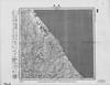
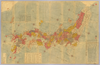
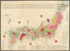
【最初期発行】 この地図の作成に当たっては、国土地理院長の承認を得て、同院発行の20万分の1地勢図及び5万分の1地形図を使用した。(承認番号 平30情使、 第1148号) (In 1 layer)
Links: Source / Biblio Ref
|
1921 | about 2 years ago | 4 control points |
|
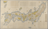
【最初期発行】 この地図の作成に当たっては、国土地理院長の承認を得て、同院発行の20万分の1地勢図及び5万分の1地形図を使用した。(承認番号 平30情使、 第1148号) (In 2 layers)
Links: Source / Biblio Ref
|
1925 | about 2 years ago | 4 control points |
|
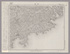
【最初期発行】 この地図の作成に当たっては、国土地理院長の承認を得て、同院発行の20万分の1地勢図及び5万分の1地形図を使用した。(承認番号 平30情使、 第1148号) (In 1 layer)
Links: Source / Biblio Ref
|
1923 | about 2 years ago | 4 control points |
|
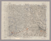
【最初期発行】 この地図の作成に当たっては、国土地理院長の承認を得て、同院発行の20万分の1地勢図及び5万分の1地形図を使用した。(承認番号 平30情使、 第1148号) (In 1 layer)
Links: Source / Biblio Ref
|
1922 | over 3 years ago | 4 control points |
|
(In 1 layer)
Links: Source / Biblio Ref
|
2020 | about 2 years ago | 10 control points |
|
|
2019 | over 5 years ago | 4 control points |
|
【最初期発行】 この地図の作成に当たっては、国土地理院長の承認を得て、同院発行の20万分の1地勢図及び5万分の1地形図を使用した。(承認番号 平30情使、 第1148号)
Links: Source / Biblio Ref
|
1929 | over 5 years ago | 4 control points |
|
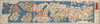
【Courtesy of the C. V. Starr East Asian Library University of California, Berkeley】 Japanese date Meiji 13 1880. In color. Folded. Mounted cover title. Copperplate print. In Japanese. Orientation varies. Relief shown pictorially. Includes 2 insets, distance chart and legend.
Links: Source / Biblio Ref
|
1880 | over 3 years ago | 5 control points |
|
【最初期発行】 この地図の作成に当たっては、国土地理院長の承認を得て、同院発行の20万分の1地勢図及び5万分の1地形図を使用した。(承認番号 平30情使、 第1148号) (In 1 layer)
Links: Source / Biblio Ref
|
1916 | almost 4 years ago | 4 control points |
|
【最初期発行】 この地図の作成に当たっては、国土地理院長の承認を得て、同院発行の20万分の1地勢図及び5万分の1地形図を使用した。(承認番号 平30情使、 第1148号) (In 1 layer)
Links: Source / Biblio Ref
|
1904 | almost 4 years ago | 4 control points |
|
【最初期発行】 この地図の作成に当たっては、国土地理院長の承認を得て、同院発行の20万分の1地勢図及び5万分の1地形図を使用した。(承認番号 平30情使、 第1148号)
Links: Source / Biblio Ref
|
1928 | over 5 years ago | 4 control points |
|
【最初期発行】 この地図の作成に当たっては、国土地理院長の承認を得て、同院発行の20万分の1地勢図及び5万分の1地形図を使用した。(承認番号 平30情使、 第1148号) (In 1 layer)
Links: Source / Biblio Ref
|
1930 | over 1 year ago | 5 control points |
|
【最初期発行】 この地図の作成に当たっては、国土地理院長の承認を得て、同院発行の20万分の1地勢図及び5万分の1地形図を使用した。(承認番号 平30情使、 第1148号) (In 1 layer)
Links: Source / Biblio Ref
|
1930 | over 5 years ago | 4 control points |
|
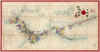
【Courtesy of the C. V. Starr East Asian Library University of California, Berkeley】 1 map : hand col. ; on sheet 83 x 126 cm., folded in cover 21 x 17 cm. Wood block print. In Japanese. Title from: Nihon chizushi / Akioka Takejiro. p. 147. Covers Matsumae to Tsushima and Ryukyu and Hachijojima. Preface by Shibano Ritsuzan in 1775. Oriented with north to the upper right. Shows longitude and latitude. Includes legend, explanation of tides, Ogasawara and Izu Shichito and text by the author. East Asian Library call number Ca-12.
Links: Source / Biblio Ref
|
1779 | over 3 years ago | 5 control points |
|
(In 1 layer)
|
2020 | over 3 years ago | 10 control points |
|
【Courtesy of the C. V. Starr East Asian Library University of California, Berkeley】 1 map : col. ; on sheet 85 x 113 cm., folded in cover 29 x 17 cm. Mounted cover title. Wood block print. Oriented with north toward the upper right. In Japanese. Engraved by Hata Kyube. Covers Matsumae to Tanegashima, Yakushima, and Tsushima. Shows longitude and latitude and sea routes with distances. Includes texts on Kuroshio and tides. Includes preface by Shibano Ritsuzan and legend. East Asian Library call number Ca 14.
Links: Source / Biblio Ref
|
1791 | over 3 years ago | 5 control points |
|
【Courtesy of the C. V. Starr East Asian Library University of California, Berkeley】 1 atlas 2 v. : 76 col. maps ; 26 cm. Wood block print. In Japanese. Preface by Saito Ken and afterword by Yamazaki Giko. Date of publication on preface and afterword. Orientation varies. Covers Matsumae to Tsushima. Engraved by Shogetsudo. Includes Dai Nihon yochi zenzu and Gokai Bunkoku chikyu zenzu. East Asian Library call number: Ca 24.5 Rare-Map.
Links: Source / Biblio Ref
|
1834 | over 3 years ago | 4 control points |
|
【Courtesy of the C. V. Starr East Asian Library University of California, Berkeley】 Japanese date Meiji 8 1875. In color. Folded. Mounted cover title. Wood block print. In Japanese. Relief shown by hachures. Orientation varies. 1 inset: Ryūkyū Shotō. Shows distance of sea routes. Includes legend.
Links: Source / Biblio Ref
|
1875 | over 3 years ago | 5 control points |
|
|
2022 | over 1 year ago | 5 control points |
|
|
2020 | over 3 years ago | 5 control points |
|
|
2023 | 12 months ago | 8 control points |
|
shelfmark: Maps 145.d.279
License: Public Domain
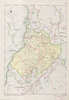
嘉永3 *多色刷り。『江戸切絵図集成』第四巻所収の嘉永3訂・図に該当。外題「駿河台小川町絵図」。初版図の刊年が嘉永3となっているが、本図の刊記は「嘉永二己酉年新刻/安政七庚申年改」。英数字・片仮名書き入れ多し。 Xylograph. Acquired 22 July 1868. Ex-Siebold. Edo kiriezu shusei 4: 40-45
Links: Source / Biblio Ref
|
1850 | over 3 years ago | 9 control points |
|
|
2022 | over 1 year ago | 3 control points |
|
shelfmark: Maps 62980.42
License: Public Domain
嘉永7 *多色刷り。「整軒玄魚図書」。外袋に「安政年製/。。。/文溪堂.文昇堂合梓」 Xylograph. Acquired 13 July 1903.
Links: Source / Biblio Ref
|
1854 | about 3 years ago | 23 control points |
|
shelfmark: Maps 62980.14
License: Public Domain
文化5 *多色刷り。刊記「浪華書籍師/藤屋弥兵衛・吉文字屋市左衛門」。外題「大日本細見指全図(改正増選)」。 Xylograph.
Links: Source / Biblio Ref
|
1808 | about 3 years ago | 25 control points |
|
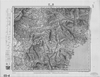
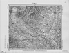
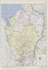
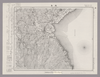
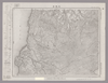
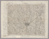
Image from the Map Collections courtesy Stanford University Libraries, licensed under a Creative Commons Attribution-Noncommercial 3.0 Unported License. © Stanford University. 【図幅名】 【測量時期】 【発行時期】 【記号】 【測量機関】 【備考】
Links: Source / Biblio Ref
|
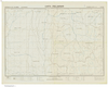
about 2 years ago | 4 control points | |
|
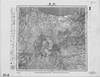
Image from the Map Collections courtesy Stanford University Libraries, licensed under a Creative Commons Attribution-Noncommercial 3.0 Unported License. © Stanford University. 【図幅名】 水戸 【測量時期】 明治36年測図/昭和15年第2回修正、測図の縮図/昭和27年応急修正 【発行時期】 昭和34年6月発行 【記号】 水戸10号(共12面) 【測量機関】 国土地理院 【備考】 応急修正版 (In 1 layer)
Links: Source / Biblio Ref
|
about 2 months ago | 4 control points | |
|
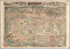
【Courtesy of the C. V. Starr East Asian Library University of California, Berkeley】 Japanese date Meiji 29 1896. In color. Folded. Copperplate print. In Japanese. Oriented with north to the left. Relief shown pictorially. Includes distance chart, index, and legend. Shows views of tourist attractions.
Links: Source / Biblio Ref
|
1896 | over 3 years ago | 4 control points |
|
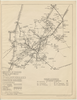
Image from the Map Collections courtesy Stanford University Libraries, licensed under a Creative Commons Attribution-Noncommercial 3.0 Unported License. © Stanford University. 【図幅名】 鹿島 【測量時期】 明治33年及大正3年測圖之縮圖/大正6年修正測圖/昭和6年鐡道補入/昭和7年部分修正測圖 【発行時期】 【記号】 熊本十四号 【測量機関】 参謀本部 【備考】 祕
Links: Source / Biblio Ref
|
about 4 years ago | 4 control points | |
|
Image from the Map Collections courtesy Stanford University Libraries, licensed under a Creative Commons Attribution-Noncommercial 3.0 Unported License. © Stanford University. 【図幅名】 熊谷 【測量時期】 明治40年測図/昭和4年修正/昭和9年要部修正/昭和14年部分修正 【発行時期】 昭和15年9月発行 【記号】 宇都宮12号(共16面) 【測量機関】 大日本帝国陸地測量部 【備考】 (In 1 layer)
Links: Source / Biblio Ref
|
about 2 years ago | 4 control points | |
|
Image from the Map Collections courtesy Stanford University Libraries, licensed under a Creative Commons Attribution-Noncommercial 3.0 Unported License. © Stanford University. 【図幅名】 金峰山 【測量時期】 明治43年測図/昭和4年要部修正 【発行時期】 昭和7年2月発行 【記号】 甲府5号(共16面) 【測量機関】 大日本帝国陸地測量部 【備考】
Links: Source / Biblio Ref
|
about 2 years ago | 4 control points | |
|
Image from the Map Collections courtesy Stanford University Libraries, licensed under a Creative Commons Attribution-Noncommercial 3.0 Unported License. © Stanford University. 【図幅名】 大根占 【測量時期】 明治34年測図/昭和7年要部修正/昭和10年部分修正/昭和20年部分修正/昭和24年資料修正 【発行時期】 昭和24年11月発行 【記号】 開聞岳1号(共7面) 【測量機関】 地理調査所 【備考】
Links: Source / Biblio Ref
|
about 4 years ago | 4 control points | |
|
Image from the Map Collections courtesy Stanford University Libraries, licensed under a Creative Commons Attribution-Noncommercial 3.0 Unported License. © Stanford University. 【図幅名】 肥前鳥ノ島 【測量時期】 明治44年測図/昭和11年修正 【発行時期】 【記号】 富江15号(共5面) 【測量機関】 参謀本部 【備考】 秘
Links: Source / Biblio Ref
|
about 4 years ago | 4 control points | |
|
Image from the Map Collections courtesy Stanford University Libraries, licensed under a Creative Commons Attribution-Noncommercial 3.0 Unported License. © Stanford University. 【図幅名】 名瀬 【測量時期】 大正9年測圖 【発行時期】 大正11年発行 【記号】 奄美大島要塞近傍十号 【測量機関】 陸地測量部・参謀本部 【備考】 軍事極祕(戦地ニ在りテハ軍事祕密トス)
Links: Source / Biblio Ref
|
about 2 months ago | 4 control points | |
|
Image from the Map Collections courtesy Stanford University Libraries, licensed under a Creative Commons Attribution-Noncommercial 3.0 Unported License. © Stanford University. 【図幅名】 邊土名 【測量時期】 大正10年測圖 【発行時期】 大正12年発行 【記号】 沖縄郡島五号 【測量機関】 陸地測量部・参謀本部 【備考】 軍事極祕(戦地ニ在りテハ軍事祕密トス)
Links: Source / Biblio Ref
|
about 2 months ago | 4 control points | |
|
|
2022 | over 1 year ago | 5 control points |
|
Image from the Map Collections courtesy Stanford University Libraries, licensed under a Creative Commons Attribution-Noncommercial 3.0 Unported License. © Stanford University. 【図幅名】 【測量時期】 【発行時期】 【記号】 【測量機関】 【備考】
Links: Source / Biblio Ref
|
over 4 years ago | 4 control points | |
|
|
2022 | over 1 year ago | 5 control points |
|
Image from the Map Collections courtesy Stanford University Libraries, licensed under a Creative Commons Attribution-Noncommercial 3.0 Unported License. © Stanford University. 【図幅名】 宇都宮 【測量時期】 明治40年測図/昭和4年第2回修正/昭和8年鉄道補入、測図の縮図 【発行時期】 昭和22年6月発行 【記号】 宇都宮1号(共16面) 【測量機関】 参謀本部 【備考】 (In 1 layer)
Links: Source / Biblio Ref
|
about 2 years ago | 4 control points | |
|
|
2022 | over 1 year ago | 5 control points |
|
Image from the Map Collections courtesy Stanford University Libraries, licensed under a Creative Commons Attribution-Noncommercial 3.0 Unported License. © Stanford University. 【図幅名】 榛名山 【測量時期】 明治44年測図/昭和4年修正/昭和9年要部修正 【発行時期】 昭和15年11月発行 【記号】 長野2号(共16面) 【測量機関】 大日本帝国陸地測量部 【備考】 (In 1 layer)
Links: Source / Biblio Ref
|
about 2 years ago | 4 control points | |
|
|
2022 | over 1 year ago | 5 control points |
|
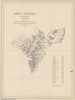
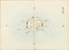
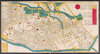
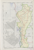
Owned by 舞鶴市糸井文庫 【成立・出版年】 文化041807
Links: Source / Biblio Ref
|
1807 | over 3 years ago | 33 control points |
|
|
2022 | over 1 year ago | 6 control points |
|
Image from the Map Collections courtesy Stanford University Libraries, licensed under a Creative Commons Attribution-Noncommercial 3.0 Unported License. © Stanford University. 【図幅名】 赤尾嶼 【測量時期】 昭和5年測圖(海上寫眞測量) 【発行時期】 昭和11年発行 【記号】 先島群島一号 【測量機関】 陸地測量部・参謀本部 【備考】 軍事極祕(戦地ニ在りテハ軍事祕密トス) 假製版
Links: Source / Biblio Ref
|
over 4 years ago | 4 control points | |
|
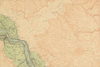
国立国会図書館デジタルコレクション インターネット公開(保護期間満了) (In 2 layers)
Links: Source / Biblio Ref
|
1853 | over 3 years ago | 24 control points |
|
Image from the Map Collections courtesy Stanford University Libraries, licensed under a Creative Commons Attribution-Noncommercial 3.0 Unported License. © Stanford University. 【図幅名】 岡山南部 【測量時期】 明治30年測図/大正14年修正 【発行時期】 【記号】 岡山及丸亀1号(共16面) 【測量機関】 参謀本部 【備考】 秘
Links: Source / Biblio Ref
|
about 2 months ago | 4 control points | |
|
Image from the Map Collections courtesy Stanford University Libraries, licensed under a Creative Commons Attribution-Noncommercial 3.0 Unported License. © Stanford University. 【図幅名】 八王子 【測量時期】 明治39年測図/大正10年修正/昭和2年第2回部分修正/昭和4年鉄道補入 【発行時期】 昭和21年9月発行 【記号】 東京11号(共16面) 【測量機関】 内務省地理調査所 【備考】 (In 1 layer)
Links: Source / Biblio Ref
|
about 2 years ago | 4 control points | |
|
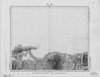
【Courtesy of the C. V. Starr East Asian Library University of California, Berkeley】 Japanese date Meiji 17 1884. In color. Folded. Mounted cover title. Title on map: Dai Nihon fuken meisho hitori annai : fu tokai benran meisho eiri. Copperplate print. In Japanese. Orientation varies. Bird's-eye view. Shows views of tourist attractions. Includes list of city names and distance chart.
Links: Source / Biblio Ref
|
1884 | over 3 years ago | 5 control points |