地図を見る
| 地図 | タイトル | 年 | 前回の更新 | ステータス  |
|---|---|---|---|---|
|
リンク: 出所・参照情報
|
2020 | 1年以上 前 | 3個の基準点 |
|
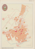
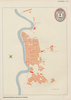
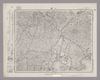
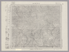
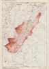
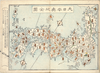
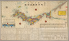
【Courtesy of the C. V. Starr East Asian Library University of California, Berkeley】 Japanese date Meiji 19 1886. In color. Folded. Mounted cover title. Title on map: Kyōto ku kumi meisaizu. Copperplate print. In Japanese. Oriented with north to the left. Relief shown pictorially. Includes distance chart, legend, and index.
リンク: 出所・参照情報
|
1886 | 3年以上 前 | 4個の基準点 |
|
リンク: 出所・参照情報
|
2020 | 1年以上 前 | 11個の基準点 |
|
国立国会図書館デジタルコレクション インターネット公開(保護期間満了) ( 2枚のレイヤー)
リンク: 出所・参照情報
|
1854 | 3年以上 前 | 31個の基準点 |
|
リンク: 出所・参照情報
|
2020 | 約1年 前 | 5個の基準点 |
|
Owned by Sainsbury Institute for the Study of Japanese Arts and Cultures 【Atlas / Book Title】 【Engraver】 【Map Size】 72 x 98 cm 【Medium】 木版刷
リンク: 出所・参照情報
|
1840 | 3年以上 前 | 22個の基準点 |
|
|
2022 | 1年以上 前 | 9個の基準点 |
|
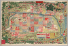
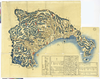
【Courtesy of the C. V. Starr East Asian Library University of California, Berkeley】 Japanese date Genji 1 1864. In color. Folded. Cover title. Wood block print. Oriented with north to the left. In Japanese. Relief shown pictorially. Title on map: Genji kaisei Miyako meisho michi no shiori no zu. Includes text on points of interest on verso by Sō Yōshi and Ryū Sōshi and legend. Drawn by Kurokawa Gyokusui.
リンク: 出所・参照情報
|
1864 | 3年以上 前 | 4個の基準点 |
|
リンク: 出所・参照情報
|
2020 | 1年以上 前 | 10個の基準点 |
|
Image from the Map Collections courtesy Stanford University Libraries, licensed under a Creative Commons Attribution-Noncommercial 3.0 Unported License. © Stanford University. 【図幅名】 陸中大原 【測量時期】 大正2年測図/昭和8年修正 【発行時期】 昭和11年3月発行 【記号】 一関10号(共14面) 【測量機関】 大日本帝国陸地測量部 【備考】
リンク: 出所・参照情報
|
約2年 前 | 4個の基準点 | |
|
|
2023 | 11ヶ月 前 | 3個の基準点 |
|
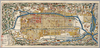
【Courtesy of the C. V. Starr East Asian Library University of California, Berkeley】 1 atlas 2 v. : 76 col. maps ; 26 cm. Wood block print. In Japanese. Preface by Saito Ken and afterword by Yamazaki Giko. Date of publication on preface and afterword. Orientation varies. Covers Matsumae to Tsushima. Engraved by Shogetsudo. Includes Dai Nihon yochi zenzu and Gokai Bunkoku chikyu zenzu. East Asian Library call number: Ca 24.5 Rare-Map.
リンク: 出所・参照情報
|
1834 | 3年以上 前 | 4個の基準点 |
|
Image from the Map Collections courtesy Stanford University Libraries, licensed under a Creative Commons Attribution-Noncommercial 3.0 Unported License. © Stanford University. 【図幅名】 小郡 【測量時期】 明治32年測図の縮図/昭和2年修正、測図の縮図/昭和15年修正、測図の縮図 【発行時期】 昭和16年4月発行 【記号】 山口12号(共15面) 【測量機関】 大日本帝国陸地測量部 【備考】
リンク: 出所・参照情報
|
約2年 前 | 4個の基準点 | |
|
Image from the Map Collections courtesy Stanford University Libraries, licensed under a Creative Commons Attribution-Noncommercial 3.0 Unported License. © Stanford University. 【図幅名】 祝島 【測量時期】 明治32年測圖/昭和11年修正測圖 【発行時期】 【記号】 中津二号 【測量機関】 参謀本部 【備考】 祕
リンク: 出所・参照情報
|
約2年 前 | 4個の基準点 | |
|
国立国会図書館デジタルコレクション インターネット公開(保護期間満了) ( 2枚のレイヤー)
リンク: 出所・参照情報
|
1862 | 3年以上 前 | 15個の基準点 |
|
国立国会図書館デジタルコレクション インターネット公開(保護期間満了) ( 1枚のレイヤー)
リンク: 出所・参照情報
|
1854 | 3年以上 前 | 21個の基準点 |
|
リンク: 出所・参照情報
|
2020 | 1年以上 前 | 9個の基準点 |
|
Image from the Map Collections courtesy Stanford University Libraries, licensed under a Creative Commons Attribution-Noncommercial 3.0 Unported License. © Stanford University. 【図幅名】 盛岡 【測量時期】 大正1年測図/昭和4年鉄道補入 【発行時期】 昭和6年6月発行 【記号】 盛岡14号(共18面) 【測量機関】 大日本帝国陸地測量部 【備考】
リンク: 出所・参照情報
|
約2年 前 | 4個の基準点 | |
|
Image from the Map Collections courtesy Stanford University Libraries, licensed under a Creative Commons Attribution-Noncommercial 3.0 Unported License. © Stanford University. 【図幅名】 人首 【測量時期】 大正2年測図/昭和8年修正 【発行時期】 昭和10年11月発行 【記号】 一関9号(共14面) 【測量機関】 大日本帝国陸地測量部 【備考】
リンク: 出所・参照情報
|
約2年 前 | 4個の基準点 | |
|
|
2022 | 約1年 前 | 8個の基準点 |
|
Image from the Map Collections courtesy Stanford University Libraries, licensed under a Creative Commons Attribution-Noncommercial 3.0 Unported License. © Stanford University. 【図幅名】 太良鉱山 【測量時期】 大正3年測図/昭和14年修正 【発行時期】 昭和16年1月発行 【記号】 弘前10号(共16面) 【測量機関】 大日本帝国陸地測量部 【備考】
リンク: 出所・参照情報
|
約2年 前 | 4個の基準点 | |
|
|
2023 | 11ヶ月 前 | 10個の基準点 |
|
Image from the Map Collections courtesy Stanford University Libraries, licensed under a Creative Commons Attribution-Noncommercial 3.0 Unported License. © Stanford University. 【図幅名】 十和田湖 【測量時期】 大正3年測図/昭和8年修正 【発行時期】 昭和10年10月発行 【記号】 弘前2号(共16面) 【測量機関】 大日本帝国陸地測量部 【備考】
リンク: 出所・参照情報
|
約2年 前 | 4個の基準点 | |
|
リンク: 出所・参照情報
|
2020 | 1年以上 前 | 3個の基準点 |
|
リンク: 出所・参照情報
|
2020 | 1年以上 前 | 4個の基準点 |
|
リンク: 出所・参照情報
|
2020 | 1年以上 前 | 5個の基準点 |
|
【Courtesy of the C. V. Starr East Asian Library University of California, Berkeley】 1 map ; 50 x 174 cm., folded in cover 23 x 15 cm. Mounted cover title. Copperplate print. In Japanese. Oriented with north to the upper right. Relief shown by hachures. Insets: Tanegashima and Oshima and Ryukyu ... et al. Ancillary map pasted on the right of map: Hokkaido. Includes distance chart and legend. East Asian Library call number: Cb80.
リンク: 出所・参照情報
|
1883 | 3年以上 前 | 4個の基準点 |
|
リンク: 出所・参照情報
|
2020 | 1年以上 前 | 5個の基準点 |
|
【Courtesy of the C. V. Starr East Asian Library University of California, Berkeley】 1 map : col. ; 35 x 142 cm., folded in cover 19 x 12 cm. Mounted cover title. Copperplate print. In Japanese. Oriented with north to the upper right. Relief shown by hachures. Insets: Hokkaido -- Ryukyu Chuhokubu Shoto -- Ryukyu Nanbu Shoto. Includes legend. Shows distances of roads. East Asian Library call number: Cb90.
リンク: 出所・参照情報
|
1886 | 3年以上 前 | 4個の基準点 |
|
|
2023 | 11ヶ月 前 | 6個の基準点 |
|
【Courtesy of the C. V. Starr East Asian Library University of California, Berkeley】 1 map : col. ; 82 x 62 cm., folded in cover 19 x 13 cm. Copperplate print. In Japanese. Relief shown by hachures. 5 insets: Hokkaido Chishima Shoto no zu -- Karafuto-shu zenzu -- Ryukyu Shoto -- Ryukyu Gunto no uchi Miyako Shoto -- Ogasawara Gunto sozu. Includes list of shrines and legend. East Asian Library call number: Cb23.
リンク: 出所・参照情報
|
1875 | 3年以上 前 | 4個の基準点 |
|
【Courtesy of the C. V. Starr East Asian Library University of California, Berkeley】 1 map : col. ; 122 x 82 cm., folded in cover 25 x 18 cm. Copperplate print. In Japanese. Relief shown by hachures. Oriented with north to the upper left. 5 insets: Karafuto-shu no zu -- Ryukyu Shoto no zu -- Ryukyu Miyakojima no zu -- Hokkaido Chishima Shoto no zu -- Ogasawara Gunto no zu. Includes legend. East Asian Library call number: Cb20.
リンク: 出所・参照情報
|
1875 | 3年以上 前 | 4個の基準点 |
|
【Courtesy of the C. V. Starr East Asian Library University of California, Berkeley】 1 map : col. ; 36 x 146 cm., folded in cover 19 x 13 cm. Mounted cover title. Wood block print. In Japanese. Orientation varies. Relief shown by hachures. Insets: Ryukyu Shoto zu -- Donai Miyako Shoto -- Izu Shichito. Includes distance chart and legend. East Asian Library call number: Cb60.
リンク: 出所・参照情報
|
1877 | 3年以上 前 | 4個の基準点 |
|
【Courtesy of the C. V. Starr East Asian Library University of California, Berkeley】 1 map : col. ; 32 x 135 cm., folded in cover 17 x 9 cm. Mounted cover title. Copperplate print. In Japanese. Relief shown pictorially. Insets: Chishima Rento -- Okinawa-ken. Includes text and legend. Orientation varies. East Asian Library call number: Cb69.
リンク: 出所・参照情報
|
1881 | 約3年 前 | 36個の基準点 |
|
【Courtesy of the C. V. Starr East Asian Library University of California, Berkeley】 Mounted cover title. Copperplate print. In Japanese. Relief shown by hachures. Includes 1 inset: Maebashi shigaizu. Includes populations, text, preface and legend. List of districts pasted on the left of map.
リンク: 出所・参照情報
|
1879 | 3年弱 前 | 23個の基準点 |
|
【Courtesy of the C. V. Starr East Asian Library University of California, Berkeley】 1 atlas 2 v. : 76 col. maps ; 26 cm. Wood block print. In Japanese. Preface by Saito Ken and afterword by Yamazaki Giko. Date of publication on preface and afterword. Orientation varies. Covers Matsumae to Tsushima. Engraved by Shogetsudo. Includes Dai Nihon yochi zenzu and Gokai Bunkoku chikyu zenzu. East Asian Library call number: Ca 24.5 Rare-Map.
リンク: 出所・参照情報
|
1834 | 3年以上 前 | 4個の基準点 |
|
Image from the Map Collections courtesy Stanford University Libraries, licensed under a Creative Commons Attribution-Noncommercial 3.0 Unported License. © Stanford University. 【図幅名】 飯浦 【測量時期】 明治32年測図/昭和7年要部修正 【発行時期】 昭和8年12月発行 【記号】 中津8号(共3面) 【測量機関】 大日本帝国陸地測量部 【備考】
リンク: 出所・参照情報
|
約2年 前 | 4個の基準点 | |
|
【Courtesy of the C. V. Starr East Asian Library University of California, Berkeley】 1 map : col. ; 33 x 79 cm., folded in cover 19 x 13 cm. Copperplate print. In Japanese. Oriented with north to the upper right. Includes lists of prefectures, mountains and rivers. Relief shown pictorially. Includes views of 2 ports, distance chart and legend. Engraved by Minaguchi Garyuken Seifu. East Asian Library call number: Cb21.
リンク: 出所・参照情報
|
1868 | 3年以上 前 | 4個の基準点 |
|
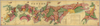
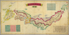
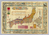
【Courtesy of the C. V. Starr East Asian Library University of California, Berkeley】 1 map : col. ; on sheet 77 x 244 cm., folded in cover 25 x 18 cm. Mounted cover title. Title on map: Dai Nihon zenzu. Wood block print. In Japanese. Relief shown pictorially. Oriented with north to the upper right. Includes ancillary map, list of prefectures, distance chart and legend. East Asian Library call number: Cb11.
リンク: 出所・参照情報
|
1874 | 3年以上 前 | 4個の基準点 |
|
【Courtesy of the C. V. Starr East Asian Library University of California, Berkeley】 1 map : col. ; 46 x 69 cm., folded in cover 25 x 18 cm. Mounted cover title. Wood block print. In Japanese. Covers Honshu to Kyushu. Oriented with north to the upper right. Publication date by the preface. Includes 3 insets: Chosen.--Ryukyu.--Ezo. Shows distance of sea routes. Includes text. East Asian Library call number: Ca 18 SPEC-Map.
リンク: 出所・参照情報
|
1816 | 3年以上 前 | 4個の基準点 |
|
【Courtesy of the C. V. Starr East Asian Library University of California, Berkeley】 1 map : col. ; 59 x 118 cm., folded in cover 22 x 16 cm. Mounted cover title. Copperplate print. In Japanese. Relief shown by hachures. Includes distance chart, preface, and legend. Oriented with north to the upper right. Title on map: Dai Nihon riteizu. East Asian Library call number: Cb29.
リンク: 出所・参照情報
|
1876 | 3年以上 前 | 4個の基準点 |
|
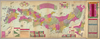
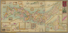
【Courtesy of the C. V. Starr East Asian Library University of California, Berkeley】 1 map : col. ; 46 x 110 cm., folded in cover 25 x 17 cm. Cover title. Copperplate print. In Japanese. Oriented with north to the upper right. Relief shown by hachures. 5 insets: Hokkaido zenzu -- Chosen zenkoku ryakuzu -- Okinawa-ken Ryukyu Shoto zenzu ... et al.. Includes views of points of interest, list of district names, charts of mountains and rivers, and legend. Shows distances of roads and sea routes. East Asian Library call number: Cb124.
リンク: 出所・参照情報
|
1892 | 3年以上 前 | 4個の基準点 |
|
|
2023 | 11ヶ月 前 | 8個の基準点 |
|
Image from the Map Collections courtesy Stanford University Libraries, licensed under a Creative Commons Attribution-Noncommercial 3.0 Unported License. © Stanford University. 【図幅名】 上ノ国 【測量時期】 大正6年測図 【発行時期】 大正9年1月発行 【記号】 函館14号(共14面) 【測量機関】 内務省地理調査所 【備考】 ( 1枚のレイヤー)
リンク: 出所・参照情報
|
約2年 前 | 4個の基準点 | |
|
【Courtesy of the C. V. Starr East Asian Library University of California, Berkeley】 1 map : col. ; 34 x 55 cm., folded to 17 x 9 cm. Copperplate print. In Japanese. Oriented with north to the upper right. Relief shown by hachures. Includes 7 insets, list of prefectures and legend. Shows views of tourist attractions. East Asian Library call number: Cb73.
リンク: 出所・参照情報
|
1881 | 3年以上 前 | 5個の基準点 |
|
【Courtesy of the C. V. Starr East Asian Library University of California, Berkeley】 1 map : col. ; 51 x 109 cm., folded in cover 19 x 13 cm. Mounted cover title. Copperplate print. In Japanese. Oriented with north to the upper right. Relief shown by hachures. 7 insets: Hokkaido zenzu -- Chishima zenbu -- Osumi Shichito -- Okinawa Shoto ... et al. Includes views of points of interest, charts of mountains and rivers, distance chart and legend. Shows sea routes with distance. East Asian Library call number: Cb109.
リンク: 出所・参照情報
|
1889 | 3年以上 前 | 4個の基準点 |
|
|
2020 | 3年以上 前 | 17個の基準点 |
|
Image from the Map Collections courtesy Stanford University Libraries, licensed under a Creative Commons Attribution-Noncommercial 3.0 Unported License. © Stanford University. 【図幅名】 久遠 【測量時期】 大正6年測図 【発行時期】 大正9年1月発行 【記号】 久遠3号(共9面) 【測量機関】 大日本帝国陸地測量部 【備考】 ( 1枚のレイヤー)
リンク: 出所・参照情報
|
約2年 前 | 4個の基準点 | |
|
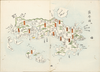
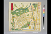
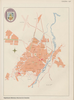
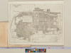
「The guide to the celebrated places in Kiyoto & the surrounding places for the foreign visitors」(同志社大学所蔵)一部です。
リンク: 出所・参照情報
|
2024 | 2ヶ月 前 | 18個の基準点 |
|
|
2023 | 11ヶ月 前 | 10個の基準点 |