地図を見る
| 地図 | タイトル | 年  |
前回の更新 | ステータス |
|---|---|---|---|---|
|
老松
|
約6年 前 | 4個の基準点 | |
|
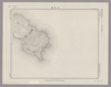
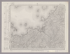
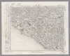
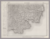
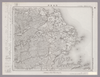
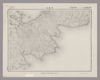
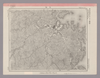
Image from the Map Collections courtesy Stanford University Libraries, licensed under a Creative Commons Attribution-Noncommercial 3.0 Unported License. © Stanford University. 【図幅名】 伊江島 【測量時期】 大正10年測圖 【発行時期】 大正12年発行 【記号】 沖縄郡島九号 【測量機関】 陸地測量部・参謀本部 【備考】 軍事極祕(戦地ニ在りテハ軍事祕密トス)
リンク: 出所・参照情報
|
5年以上 前 | 4個の基準点 | |
|
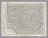
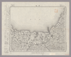
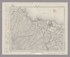
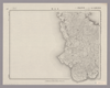
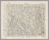
Image from the Map Collections courtesy Stanford University Libraries, licensed under a Creative Commons Attribution-Noncommercial 3.0 Unported License. © Stanford University. 【図幅名】 北条 【測量時期】 明治26年測図/大正12年第2回修正/昭和2年鉄道補入 【発行時期】 昭和3年8月発行 【記号】 姫路3号(共16面) 【測量機関】 大日本帝国陸地測量部 【備考】
リンク: 出所・参照情報
|
約2年 前 | 4個の基準点 | |
|
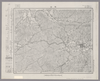
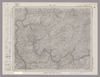
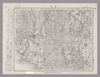
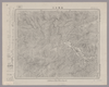
Image from the Map Collections courtesy Stanford University Libraries, licensed under a Creative Commons Attribution-Noncommercial 3.0 Unported License. © Stanford University. 【図幅名】 日原 【測量時期】 明治32年測図/昭和7年要部修正 【発行時期】 昭和9年8月発行 【記号】 山口1号(共15面) 【測量機関】 大日本帝国陸地測量部 【備考】
リンク: 出所・参照情報
|
約2年 前 | 4個の基準点 | |

|
|
7年弱 前 | 整形を解除する | |
|
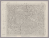
Image from the Map Collections courtesy Stanford University Libraries, licensed under a Creative Commons Attribution-Noncommercial 3.0 Unported License. © Stanford University. 【図幅名】 【測量時期】 【発行時期】 【記号】 【測量機関】 【備考】
リンク: 出所・参照情報
|
約2年 前 | 4個の基準点 | |
|
Image from the Map Collections courtesy Stanford University Libraries, licensed under a Creative Commons Attribution-Noncommercial 3.0 Unported License. © Stanford University. 【図幅名】 国分 【測量時期】 明治34年測図/大正2年測図の縮図/昭和7年第2回修正、測図の縮図/昭和10年部分修正 【発行時期】 昭和21年11月発行 【記号】 鹿児島2号(共16面) 【測量機関】 内務省地理調査所 【備考】
リンク: 出所・参照情報
|
約4年 前 | 4個の基準点 | |
|
Image from the Map Collections courtesy Stanford University Libraries, licensed under a Creative Commons Attribution-Noncommercial 3.0 Unported License. © Stanford University. 【図幅名】 富江 【測量時期】 明治33年測図/昭和13年測図の縮図/昭和11年修正 【発行時期】 昭和21年11月発行 【記号】 富江1号(共5面) 【測量機関】 地理調査所 【備考】
リンク: 出所・参照情報
|
4年弱 前 | 4個の基準点 | |
|
Image from the Map Collections courtesy Stanford University Libraries, licensed under a Creative Commons Attribution-Noncommercial 3.0 Unported License. © Stanford University. 【図幅名】 志布志 【測量時期】 明治34年測図/昭和7年第2回修正、測図の縮図/昭和10年部分修正/昭和24年資料修正 【発行時期】 昭和24年6月発行 【記号】 宮崎16号(共8面) 【測量機関】 地理調査所 【備考】
リンク: 出所・参照情報
|
約4年 前 | 4個の基準点 | |
|
Image from the Map Collections courtesy Stanford University Libraries, licensed under a Creative Commons Attribution-Noncommercial 3.0 Unported License. © Stanford University. 【図幅名】 都城 【測量時期】 明治34年測図/大正4年測図の縮図/昭和7年第2回修正、測図の縮図/昭和10年部分修正 【発行時期】 【記号】 宮崎14号(共8面) 【測量機関】 参謀本部 【備考】 秘
リンク: 出所・参照情報
|
約4年 前 | 4個の基準点 | |
|
shelfmark: Maps 149.e.22
License: Public Domain
江戸後期写 Manuscript, early 19th century. Acquired 22 July 1868. Ex-Siebold.
リンク: 出所・参照情報
|
6ヶ月 前 | 整形を解除する | |
|
Image from the Map Collections courtesy Stanford University Libraries, licensed under a Creative Commons Attribution-Noncommercial 3.0 Unported License. © Stanford University. 【図幅名】 萩 【測量時期】 明治32年測圖/昭和2年要部修正測圖/昭和7年鐡道補入/昭和15年部分修正測圖 【発行時期】 【記号】 山口十号 【測量機関】 参謀本部 【備考】 祕
リンク: 出所・参照情報
|
約2年 前 | 4個の基準点 | |
|
Image from the Map Collections courtesy Stanford University Libraries, licensed under a Creative Commons Attribution-Noncommercial 3.0 Unported License. © Stanford University. 【図幅名】 塩尻 【測量時期】 明治43年測図/昭和6年修正、測図の縮図 【発行時期】 昭和9年4月発行 【記号】 高山4号(共16面) 【測量機関】 大日本帝国陸地測量部 【備考】
リンク: 出所・参照情報
|
約2年 前 | 4個の基準点 | |
|
Image from the Map Collections courtesy Stanford University Libraries, licensed under a Creative Commons Attribution-Noncommercial 3.0 Unported License. © Stanford University. 【図幅名】 浜崎 【測量時期】 明治33年測圖/昭和11年修正測圖 【発行時期】 【記号】 小倉十六号 【測量機関】 参謀本部 【備考】 祕
リンク: 出所・参照情報
|
4年弱 前 | 4個の基準点 | |
|
Image from the Map Collections courtesy Stanford University Libraries, licensed under a Creative Commons Attribution-Noncommercial 3.0 Unported License. © Stanford University. 【図幅名】 甘木 【測量時期】 明治33年測圖之縮圖/昭和11年第三回修正測圖之縮圖/昭和13年測圖之縮圖 【発行時期】 【記号】 小倉八号 【測量機関】 参謀本部 【備考】 祕
リンク: 出所・参照情報
|
4年弱 前 | 4個の基準点 | |
|
Image from the Map Collections courtesy Stanford University Libraries, licensed under a Creative Commons Attribution-Noncommercial 3.0 Unported License. © Stanford University. 【図幅名】 大村 【測量時期】 明治34年測図/大正13年修正 【発行時期】 昭和21年11月発行 【記号】 長崎3号(共15面) 【測量機関】 内務省地理調査所 【備考】
リンク: 出所・参照情報
|
4年弱 前 | 4個の基準点 | |
|
Image from the Map Collections courtesy Stanford University Libraries, licensed under a Creative Commons Attribution-Noncommercial 3.0 Unported License. © Stanford University. 【図幅名】 農家 【測量時期】 大正9年測圖/昭和20年部分修正測圖(空中寫眞測圖) 【発行時期】 【記号】 浦河六号 【測量機関】 参謀本部 【備考】 祕
リンク: 出所・参照情報
|
約2年 前 | 4個の基準点 | |
|
Image from the Map Collections courtesy Stanford University Libraries, licensed under a Creative Commons Attribution-Noncommercial 3.0 Unported License. © Stanford University.
リンク: 出所・参照情報
|
約6年 前 | 4個の基準点 | |
|
Image from the Map Collections courtesy Stanford University Libraries, licensed under a Creative Commons Attribution-Noncommercial 3.0 Unported License. © Stanford University. 【図幅名】 白峰 【測量時期】 明治43年測図/昭和5年要部修正 【発行時期】 昭和8年1月発行 【記号】 金沢7号(共13面) 【測量機関】 大日本帝国陸地測量部 【備考】
リンク: 出所・参照情報
|
約2年 前 | 4個の基準点 | |
|
Image from the Map Collections courtesy Stanford University Libraries, licensed under a Creative Commons Attribution-Noncommercial 3.0 Unported License. © Stanford University.
リンク: 出所・参照情報
|
約6年 前 | 4個の基準点 | |
|
Image from the Map Collections courtesy Stanford University Libraries, licensed under a Creative Commons Attribution-Noncommercial 3.0 Unported License. © Stanford University. 【図幅名】 福岡 【測量時期】 明治33年測圖之縮圖/昭和11年第二回修正測圖之縮圖 【発行時期】 【記号】 小倉十一号 【測量機関】 参謀本部 【備考】 祕
リンク: 出所・参照情報
|
4年弱 前 | 4個の基準点 | |
|
( 4枚のレイヤー)
|
4年以上 前 | 4個の基準点 | |
|
Image from the Map Collections courtesy Stanford University Libraries, licensed under a Creative Commons Attribution-Noncommercial 3.0 Unported License. © Stanford University. 【図幅名】 宇佐 【測量時期】 明治36年測圖/昭和2年修正測圖 【発行時期】 【記号】 中津十一号 【測量機関】 参謀本部 【備考】 祕
リンク: 出所・参照情報
|
5年以上 前 | 4個の基準点 | |

|
老松
|
4年以上 前 | 4個の基準点 | |
|
Image from the Map Collections courtesy Stanford University Libraries, licensed under a Creative Commons Attribution-Noncommercial 3.0 Unported License. © Stanford University. 【図幅名】 篠山 【測量時期】 明治26年測図/大正9年修正/昭和2年鉄道補入 【発行時期】 【記号】 京都及大阪14号(共16面) 【測量機関】 参謀本部 【備考】 秘
リンク: 出所・参照情報
|
約2年 前 | 4個の基準点 | |
|
Image from the Map Collections courtesy Stanford University Libraries, licensed under a Creative Commons Attribution-Noncommercial 3.0 Unported License. © Stanford University. 【図幅名】 千頭 【測量時期】 明治41年測図/昭和8年要部修正 【発行時期】 昭和11年4月発行 【記号】 静岡14号(共15面) 【測量機関】 大日本帝国陸地測量部 【備考】
リンク: 出所・参照情報
|
約2年 前 | 4個の基準点 | |
|
Image from the Map Collections courtesy Stanford University Libraries, licensed under a Creative Commons Attribution-Noncommercial 3.0 Unported License. © Stanford University. 【図幅名】 豊後杵築 【測量時期】 明治36年測圖/昭和2年要部修正測圖 【発行時期】 【記号】 中津八号 【測量機関】 参謀本部 【備考】 祕
リンク: 出所・参照情報
|
4年弱 前 | 4個の基準点 | |
|
Image from the Map Collections courtesy Stanford University Libraries, licensed under a Creative Commons Attribution-Noncommercial 3.0 Unported License. © Stanford University. 【図幅名】 中津 【測量時期】 明治35年測圖/昭和16年第二回修正測圖 【発行時期】 【記号】 中津十五号 【測量機関】 参謀本部 【備考】 祕
リンク: 出所・参照情報
|
4年弱 前 | 4個の基準点 | |
|
Image from the Map Collections courtesy Stanford University Libraries, licensed under a Creative Commons Attribution-Noncommercial 3.0 Unported License. © Stanford University. 【図幅名】 川口 【測量時期】 明治40年測図/昭和8年修正 【発行時期】 昭和11年5月発行 【記号】 高知1号(共16面) 【測量機関】 大日本帝国陸地測量部 【備考】
リンク: 出所・参照情報
|
約2年 前 | 4個の基準点 | |
|
Image from the Map Collections courtesy Stanford University Libraries, licensed under a Creative Commons Attribution-Noncommercial 3.0 Unported License. © Stanford University. 【図幅名】 焼尻島 【測量時期】 大正11年測図 【発行時期】 大正13年5月発行 【記号】 羽幌10号(共8面) 【測量機関】 大日本帝国陸地測量部 【備考】 仮製版 ( 1枚のレイヤー)
リンク: 出所・参照情報
|
約2年 前 | 4個の基準点 | |
|
|
5ヶ月 前 | 2個の基準点 | |
|
|
5ヶ月 前 | 4個の基準点 | |
|
Image from the Map Collections courtesy Stanford University Libraries, licensed under a Creative Commons Attribution-Noncommercial 3.0 Unported License. © Stanford University. 【図幅名】 足摺崎 【測量時期】 明治37年測図/昭和8年修正 【発行時期】 昭和11年4月発行 【記号】 窪川16号(共4面) 【測量機関】 大日本帝国陸地測量部 【備考】
リンク: 出所・参照情報
|
約2年 前 | 4個の基準点 | |
|
Image from the Map Collections courtesy Stanford University Libraries, licensed under a Creative Commons Attribution-Noncommercial 3.0 Unported License. © Stanford University. 【図幅名】 三島 【測量時期】 明治39年測図/昭和3年修正 【発行時期】 昭和7年1月発行 【記号】 高知5号(共16面) 【測量機関】 大日本帝国陸地測量部 【備考】 ( 1枚のレイヤー)
リンク: 出所・参照情報
|
約2年 前 | 4個の基準点 | |

|
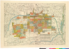
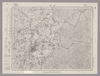
老松が作成し、使用している京都市細図。
|
5年以上 前 | 24個の基準点 | |
|
Image from the Map Collections courtesy Stanford University Libraries, licensed under a Creative Commons Attribution-Noncommercial 3.0 Unported License. © Stanford University.
リンク: 出所・参照情報
|
約6年 前 | 4個の基準点 | |
|
Image from the Map Collections courtesy Stanford University Libraries, licensed under a Creative Commons Attribution-Noncommercial 3.0 Unported License. © Stanford University. 【図幅名】 石鎚山 【測量時期】 明治39年測図/昭和8年修正 【発行時期】 昭和11年12月発行 【記号】 高知14号(共16面) 【測量機関】 大日本帝国陸地測量部 【備考】 ( 1枚のレイヤー)
リンク: 出所・参照情報
|
約2年 前 | 4個の基準点 | |
|
Image from the Map Collections courtesy Stanford University Libraries, licensed under a Creative Commons Attribution-Noncommercial 3.0 Unported License. © Stanford University. 【図幅名】 青島 【測量時期】 明治32年測図/昭和2年修正 【発行時期】 昭和21年4月発行 【記号】 松山10号(共13面) 【測量機関】 内務省地理調査所 【備考】
リンク: 出所・参照情報
|
約2年 前 | 4個の基準点 | |
|
Image from the Map Collections courtesy Stanford University Libraries, licensed under a Creative Commons Attribution-Noncommercial 3.0 Unported License. © Stanford University. 【図幅名】 小値賀島 【測量時期】 明治36年測図/昭和11年修正/昭和13年測図の縮図 【発行時期】 昭和21年11月発行 【記号】 長崎13号(共15面) 【測量機関】 地理調査所 【備考】
リンク: 出所・参照情報
|
4年弱 前 | 4個の基準点 | |
|
Image from the Map Collections courtesy Stanford University Libraries, licensed under a Creative Commons Attribution-Noncommercial 3.0 Unported License. © Stanford University. 【図幅名】 阿波富岡 【測量時期】 明治40年測図/昭和9年第2回修正、測図の縮図 【発行時期】 【記号】 剣山5号(共11面) 【測量機関】 陸地測量部 【備考】 秘
リンク: 出所・参照情報
|
約2年 前 | 4個の基準点 | |
|
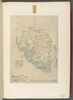
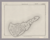
Image from the Map Collections courtesy Stanford University Libraries, licensed under a Creative Commons Attribution-Noncommercial 3.0 Unported License. © Stanford University. 【図幅名】 奥 【測量時期】 大正10年測圖 【発行時期】 大正12年発行 【記号】 沖縄郡島一号 【測量機関】 陸地測量部・参謀本部 【備考】 軍事極祕(戦地ニ在りテハ軍事祕密トス)
リンク: 出所・参照情報
|
5年以上 前 | 4個の基準点 | |
|
shelfmark: Maps 149.e.241
License: Public Domain
江戸後期刊 Manuscript, early 19th century. Acquired 22 July 1868. Ex-Siebold.
リンク: 出所・参照情報
|
4年以上 前 | 整形を解除する | |
|
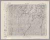
Image from the Map Collections courtesy Stanford University Libraries, licensed under a Creative Commons Attribution-Noncommercial 3.0 Unported License. © Stanford University. 【図幅名】 沖永良部島 【測量時期】 大正9年測圖 【発行時期】 昭和11年発行 【記号】 奄美大島要塞近傍十八号 【測量機関】 陸地測量部・参謀本部 【備考】 軍事極祕(戦地ニ在りテハ軍事祕密トス)
リンク: 出所・参照情報
|
5年以上 前 | 4個の基準点 | |
|
Image from the Map Collections courtesy Stanford University Libraries, licensed under a Creative Commons Attribution-Noncommercial 3.0 Unported License. © Stanford University. 【図幅名】 仲尾次 【測量時期】 大正10年測圖 【発行時期】 大正12年発行 【記号】 沖縄郡島六号 【測量機関】 陸地測量部・参謀本部 【備考】 軍事極祕(戦地ニ在りテハ軍事祕密トス)
リンク: 出所・参照情報
|
約1ヶ月 前 | 4個の基準点 | |
|
Image from the Map Collections courtesy Stanford University Libraries, licensed under a Creative Commons Attribution-Noncommercial 3.0 Unported License. © Stanford University. 【図幅名】 平土野 【測量時期】 大正9年測圖 【発行時期】 昭和11年発行 【記号】 奄美大島要塞近傍十七号 【測量機関】 陸地測量部・参謀本部 【備考】 軍事極祕(戦地ニ在りテハ軍事祕密トス)
リンク: 出所・参照情報
|
5年以上 前 | 4個の基準点 | |
|
Image from the Map Collections courtesy Stanford University Libraries, licensed under a Creative Commons Attribution-Noncommercial 3.0 Unported License. © Stanford University. 【図幅名】 経ヶ岳 【測量時期】 明治43年測図/昭和5年要部修正 【発行時期】 昭和7年11月発行 【記号】 金沢8号(共13面) 【測量機関】 大日本帝国陸地測量部 【備考】
リンク: 出所・参照情報
|
約2年 前 | 4個の基準点 | |
|
Image from the Map Collections courtesy Stanford University Libraries, licensed under a Creative Commons Attribution-Noncommercial 3.0 Unported License. © Stanford University. 【図幅名】 高瀬 【測量時期】 明治33年測圖/大正15年第二回修正測圖/昭和6年部分修正測圖 【発行時期】 【記号】 熊本七号 【測量機関】 参謀本部 【備考】 祕
リンク: 出所・参照情報
|
4年弱 前 | 4個の基準点 | |
|
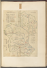
Image from the Map Collections courtesy Stanford University Libraries, licensed under a Creative Commons Attribution-Noncommercial 3.0 Unported License. © Stanford University. 【図幅名】 【測量時期】 【発行時期】 【記号】 【測量機関】 【備考】
リンク: 出所・参照情報
|
約4年 前 | 4個の基準点 | |
|
Image from the Map Collections courtesy Stanford University Libraries, licensed under a Creative Commons Attribution-Noncommercial 3.0 Unported License. © Stanford University. 【図幅名】 水海道 【測量時期】 明治40年測図/昭和4年修正/昭和35年部分修正 【発行時期】 【記号】 宇都宮4号(共16面) 【測量機関】 国土地理院 【備考】 ( 1枚のレイヤー)
リンク: 出所・参照情報
|
約2年 前 | 4個の基準点 | |
|
Image from the Map Collections courtesy Stanford University Libraries, licensed under a Creative Commons Attribution-Noncommercial 3.0 Unported License. © Stanford University. 【図幅名】 飛騨古川 【測量時期】 大正1年測図/昭和5年要部修正 【発行時期】 昭和7年9月発行 【記号】 高山15号(共16面) 【測量機関】 大日本帝国陸地測量部 【備考】
リンク: 出所・参照情報
|
約2年 前 | 4個の基準点 |