地図を見る
| 地図 | タイトル | 年 | 前回の更新 | ステータス  |
|---|---|---|---|---|
|
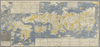
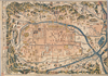
shelfmark: Or.75.f.11
License: Public Domain
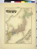
貞享4 *ケンペル旧蔵。 Xylograph. Ex-Kaempfer. Gardner #563. Kurita 17.
リンク: 出所・参照情報
|
1687 | 約3年 前 | 22個の基準点 |
|
Image from the Map Collections courtesy Stanford University Libraries, licensed under a Creative Commons Attribution-Noncommercial 3.0 Unported License. © Stanford University.
リンク: 出所・参照情報
|
約6年 前 | 4個の基準点 | |
|
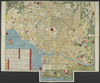
shelfmark: Maps 149.e.23
License: Public Domain
江戸後期写 Manuscript, early 19th century. Acquired 22 July 1868. Ex-Siebold.
リンク: 出所・参照情報
|
約2年 前 | 8個の基準点 | |

|
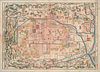
Image from the Map Collections courtesy Stanford University Libraries. This item is in the public domain. There are no restrictions on use.
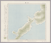
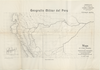
【図幅名】 三子山【測量時期】 大正2年測圖 【発行時期】大正13年 【記号】 千島列島五号 【測量機関】 参謀本部 【その他】千島列島 陸地測量部 ( 1枚のレイヤー)
リンク: 出所・参照情報
|
1924 | 1年以上 前 | 4個の基準点 |
|
shelfmark: Maps 63100.5
License: Public Domain
明治10 *多色刷り。 Xylograph.
リンク: 出所・参照情報
|
1877 | 約3年 前 | 14個の基準点 |
|
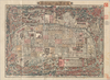
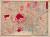
【Courtesy of the C. V. Starr East Asian Library University of California, Berkeley】 Mounted cover title. Title on map: Meisho eiri Tokyo shinzu. Copperplate print. In Japanese. Oriented with north to the right. Includes address chart and distance chart. Shows points of interest pictorially. Shows views of attractions.
リンク: 出所・参照情報
|
1883 | 3年以上 前 | 4個の基準点 |
|
shelfmark: Maps 63100.4
License: Public Domain
明治10 *多色刷り。刊記に「明治六年八月官許/明治十年二月刻成」とあり。 Xylograph. Acquired 22 July 1868. Ex-Siebold.
リンク: 出所・参照情報
|
1877 | 約3年 前 | 9個の基準点 |
|
|
2022 | 2年弱 前 | 3個の基準点 |
|
shelfmark: Maps 63145.11
License: Public Domain
明治3 *多色刷り。外題「横浜明細全図」。 Manuscript copied in the early 19th century. Purchased from Martinus Nijhof, The Hague, 8 November 1893.
リンク: 出所・参照情報
|
1870 | 約3年 前 | 7個の基準点 |
|
|
6年以上 前 | 8個の基準点 | |
|
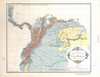
Croquis de los rios Napo y Putumayo. Geografía Militar del Perú. NOTA: Este croquis ha sido reconstruido por JORGE MARTINEZ L. y MANUEL JOSE PEÑA C.I.C con los datos, croquis y planos publicados por el Coronel Pedro Portillo en diferentes épocas; los señor Rafael E. Baluarte en 1905; los del señor Camilo Vallejos Z. en 1907, y el croquis del señor Victor Macedo que acompaña la obra EN EL PUTUMAYO Y SUS AFLUENTES, por Eugenio Robuchon. Concluido el trabajo de reconstrucción, ha sido confronttado con los informes del Ingeniero alemán von Hassel, sobre los VARADEROS o ARRASTRADEROS, y con los originales o cartera de ingeniero de Robuchon, que por muchos años se consideraron perdidos, pero ellos fueron facilitados al autor de GEOGRAFIA MILITAR DEL PERU, por el doctor Santiago Rozo. OBSEQUIO DE LA FABRICA DE LICORES Y PERFUMES DE CUNDINAMARCA
|
1930 | 6ヶ月 前 | 9個の基準点 |
|
|
1931 | 5ヶ月 前 | 3個の基準点 |
|
|
2023 | 11ヶ月 前 | 13個の基準点 |
|
リンク: 出所・参照情報
|
2020 | 2年以上 前 | 5個の基準点 |
|
Image from the Map Collections courtesy Stanford University Libraries, licensed under a Creative Commons Attribution-Noncommercial 3.0 Unported License. © Stanford University. 【図幅名】 福島 【測量時期】 明治41年測図/大正14年鉄道補入/昭和6年要部修正 【発行時期】 昭和21年11月発行 【記号】 福島10号(共18面) 【測量機関】 内務省地理調査所 【備考】
リンク: 出所・参照情報
|
約2ヶ月 前 | 4個の基準点 | |
|
Image from the Map Collections courtesy Stanford University Libraries, licensed under a Creative Commons Attribution-Noncommercial 3.0 Unported License. © Stanford University. 【図幅名】 遠野 【測量時期】 大正2年測図/昭和8年修正 【発行時期】 昭和10年2月発行 【記号】 一関5号(共14面) 【測量機関】 大日本帝国陸地測量部 【備考】
リンク: 出所・参照情報
|
約2年 前 | 4個の基準点 | |
|
PLANO DEL RIO MAGDALENA QUE MUESTRA LA ZONA DE INUNDACION Y LOS LIMITES DEL CLIMA. JBK
|
1928 | 6ヶ月 前 | 14個の基準点 |
|
Image from the Map Collections courtesy Stanford University Libraries, licensed under a Creative Commons Attribution-Noncommercial 3.0 Unported License. © Stanford University. 【図幅名】 三国 【測量時期】 【発行時期】 昭和8年8月発行 【記号】 金沢15号(共13面) 【測量機関】 大日本帝国陸地測量部 【備考】 ( 1枚のレイヤー)
リンク: 出所・参照情報
|
約2年 前 | 4個の基準点 | |
|
Gráfico para mostrar la densidad de la población y el volumen del tráfico anual en las distintas vías fluviales, ferrocarriles y cables en la REPUBLICA DE COLOMBIA. Corresponde a los datos del año 1923. Konsortium de Julius Berger. Agosto 1924
|
1928 | 6ヶ月 前 | 12個の基準点 |
|
【Courtesy of the C. V. Starr East Asian Library University of California, Berkeley】 Lithograph. In Japanese. Oriented with north to the left. Relief shown pictorially. Includes distance chart and legend.
リンク: 出所・参照情報
|
1900 | 3年以上 前 | 4個の基準点 |
|
Mapa de la Región Hidrográfica del Amazonas Peruano CON SUS AFLUENTES NAVEGABLES. Mandado trazar por la SOCIEDAD GEOGRAFICA DE LIMA. Por MAX DOIG. PRIMER MAPA. OBSEQUI DE LA FABRICA DE LICORES Y PERFUMES DE CUNDINAMARCA
|
1930 | 6ヶ月 前 | 12個の基準点 |
|
Image from the Map Collections courtesy Stanford University Libraries, licensed under a Creative Commons Attribution-Noncommercial 3.0 Unported License. © Stanford University. 【図幅名】 伊集院 【測量時期】 明治35年測圖/昭和7年修正測圖及修正測圖之縮圖/昭和10年部分修正測圖 【発行時期】 【記号】 鹿児島十一号 【測量機関】 参謀本部 【備考】 祕
リンク: 出所・参照情報
|
約4年 前 | 4個の基準点 | |
|
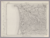
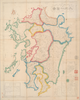
shelfmark: Maps 149.e.256
License: Public Domain
江戸後期刊 *(刊記書肆)書林/京都、菊屋七郎兵衛/大坂、河内屋喜兵衛・河内屋茂兵衛/江戸、須原屋茂兵衛・須原屋佐助・須原屋伊八・岡田屋嘉七・英大助・小林新兵衛・山城屋佐兵衛・菊屋幸三郎板。外題「相模国全図」。 Xylograph. Acquired 22 July 1868. Ex-Siebold.
リンク: 出所・参照情報
|
約2年 前 | 35個の基準点 | |
|
Image from the Map Collections courtesy Stanford University Libraries, licensed under a Creative Commons Attribution-Noncommercial 3.0 Unported License. © Stanford University. 【図幅名】 槍ヶ嶽 【測量時期】 大正元年測圖/昭和5年修正測圖(地上寫真測量併用) 【発行時期】 昭和7年発行 【記号】 高山六号 【測量機関】 大日本帝國陸地測量部 【備考】
リンク: 出所・参照情報
|
約2年 前 | 4個の基準点 | |
|
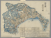
shelfmark: Maps 149.e.223
License: Public Domain
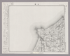
江戸中期刊 *外題「(改正)和泉国大絵図」。無刊記。 Xylograph. Acquired 22 July 1868. Ex-Siebold.
リンク: 出所・参照情報
|
3年以上 前 | 32個の基準点 | |
|
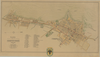
【Courtesy of the C. V. Starr East Asian Library University of California, Berkeley】 Mounted cover title. Wood block print. Oriented with north to the left. In Japanese. Relief shown pictorially. Includes legend.
リンク: 出所・参照情報
|
1843 | 3年以上 前 | 4個の基準点 |
|
Image from the Map Collections courtesy Stanford University Libraries, licensed under a Creative Commons Attribution-Noncommercial 3.0 Unported License. © Stanford University. 【図幅名】 姫路 【測量時期】 明治26年測図/明治28年測図/大正12年第2回修正/昭和7年鉄道補入/昭和24年応急修正/昭和35年資料修正 【発行時期】 昭和35年6月発行 【記号】 姫路8号 【測量機関】 国土地理院 【備考】
リンク: 出所・参照情報
|
約1ヶ月 前 | 4個の基準点 | |
|
【Courtesy of the C. V. Starr East Asian Library University of California, Berkeley】 Mounted cover title. Lithograph. In Japanese. Relief shown by hachures. Includes 3 insets, distance chart, and legend.
リンク: 出所・参照情報
|
1877 | 3年以上 前 | 4個の基準点 |
|
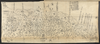
shelfmark: Maps 38.b.171
License: Public Domain
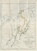
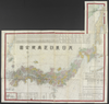
明治8 *銅板。多色刷り。外題「(蒔田愛敬編輯)皇国新図(附府県官弊国弊社)」。北海道・樺太・千島列島・琉球諸島等を含む。 Copperplate. Includes Hokkaido, Karafuto i.e., Sakhalin, the Chishima archipelago i.e., Kurile Islands and the Ryukyu islands i.e., Okinawa Prefecture.
リンク: 出所・参照情報
|
1875 | 約3年 前 | 25個の基準点 |
|
【Courtesy of the C. V. Starr East Asian Library University of California, Berkeley】 Mounted cover title. Copperplate print. In Japanese. Oriented with north to the upper right. Includes address chart pasted on the bottom of map. Includes legend.
リンク: 出所・参照情報
|
1880 | 3年以上 前 | 4個の基準点 |
|
shelfmark: Maps 38.b.164
License: Public Domain
明治5 *銅板。多色刷り。外題「(銅刻)大日本改正輿地全図」。北海道・樺太・千島列島等を含む。(刊記)免許文化八辛未年七月/再刻天保八丁酉年九月/三刻天保十四癸卯年九月/四刻慶応三丁卯八月/五刻明治五壬申年十一月銅刻/東京書肆玉養堂若林喜兵衛蔵板。(枠外)木村楊堂縮写並銅鐫。 Copperplate.
リンク: 出所・参照情報
|
1872 | 3年以上 前 | 16個の基準点 |
|
|
2020 | 4年弱 前 | 7個の基準点 |
|
|
1901 | 5ヶ月 前 | 4個の基準点 |
|
Image from the Map Collections courtesy Stanford University Libraries, licensed under a Creative Commons Attribution-Noncommercial 3.0 Unported License. © Stanford University. 【図幅名】 信濃池田 【測量時期】 明治43年測図/昭和5年測図/昭和6年修正 【発行時期】 昭和8年8月発行 【記号】 高山2号(共16面) 【測量機関】 大日本帝国陸地測量部 【備考】
リンク: 出所・参照情報
|
約2年 前 | 4個の基準点 | |
|
この地図の作成に当たっては、国土地理院長の承認を得て、同院発行の20万分の1地勢図及び5万分の1地形図を使用した。(承認番号 平30情使、 第1148号)
リンク: 出所・参照情報
|
1947 | 約1ヶ月 前 | 4個の基準点 |
|
|
2022 | 2年弱 前 | 5個の基準点 |
|
この地図の作成に当たっては、国土地理院長の承認を得て、同院発行の20万分の1地勢図及び5万分の1地形図を使用した。(承認番号 平30情使、 第1148号)
リンク: 出所・参照情報
|
1947 | 約1ヶ月 前 | 4個の基準点 |
|
【Courtesy of the C. V. Starr East Asian Library University of California, Berkeley】 In Japanese. Relief shown by hachures. Includes distance chart, seasonal calendar, 1 inset and legend.
リンク: 出所・参照情報
|
1906 | 3年以上 前 | 4個の基準点 |
|
Image from the Map Collections courtesy Stanford University Libraries, licensed under a Creative Commons Attribution-Noncommercial 3.0 Unported License. © Stanford University. 【図幅名】 高砂 【測量時期】 明治29年測図/大正2年第2回修正 【発行時期】 【記号】 姫路4号(共16面) 【測量機関】 参謀本部 【備考】 秘
リンク: 出所・参照情報
|
約1ヶ月 前 | 4個の基準点 | |
|
Image from the Map Collections courtesy Stanford University Libraries, licensed under a Creative Commons Attribution-Noncommercial 3.0 Unported License. © Stanford University. 【図幅名】 宮之城 【測量時期】 明治34年測圖/昭和7年要部修正測圖/昭和10年部分修正測圖 【発行時期】 【記号】 鹿児島九号 【測量機関】 参謀本部 【備考】 祕
リンク: 出所・参照情報
|
4年弱 前 | 4個の基準点 | |
|
Image from the Map Collections courtesy Stanford University Libraries, licensed under a Creative Commons Attribution-Noncommercial 3.0 Unported License. © Stanford University. 【図幅名】 大垣 【測量時期】 明治24年測図の縮図/明治39年測図/昭和7年第2回修正、測図の縮図 【発行時期】 昭和9年12月発行 【記号】 岐阜8号(共16面) 【測量機関】 大日本帝国陸地測量部 【備考】
リンク: 出所・参照情報
|
約1ヶ月 前 | 4個の基準点 | |
|
( 1枚のレイヤー)
|
2020 | 3年以上 前 | 5個の基準点 |
|
|
2018 | 5年以上 前 | 18個の基準点 |
|
Image from the Map Collections courtesy Stanford University Libraries, licensed under a Creative Commons Attribution-Noncommercial 3.0 Unported License. © Stanford University. 【図幅名】 鹿沼 【測量時期】 明治40年測図/昭和4年要部修正 【発行時期】 昭和6年8月発行 【記号】 宇都宮5号(共16面) 【測量機関】 大日本帝国陸地測量部 【備考】 ( 1枚のレイヤー)
リンク: 出所・参照情報
|
約2年 前 | 4個の基準点 | |
|
shelfmark: Maps 38.c.213
License: Public Domain
安政2 *多色刷り。刊年は大英図書館蔵図(Maps 149.e.237)による。外大「上野国全図」。(刊記)書林/京都、菊屋幸三郎/上州高崎、菊屋源兵衛/上州I吾妻郡赤羽根、木屋仙吉/江戸、須原屋茂兵衛・須原屋佐助・須原屋伊八・岡田屋嘉七・和泉屋金右衛門・小林新兵衛・山城屋佐兵衛・菊屋幸三郎板(下線部は入れ木)。 Xylograph.
リンク: 出所・参照情報
|
1855 | 3年以上 前 | 25個の基準点 |
|
Image from the Map Collections courtesy Stanford University Libraries, licensed under a Creative Commons Attribution-Noncommercial 3.0 Unported License. © Stanford University. 【図幅名】 白川村 【測量時期】 明治43年測図/昭和5年要部修正 【発行時期】 昭和21年10月発行 【記号】 金沢3号(共13面) 【測量機関】 地理調査所 【備考】
リンク: 出所・参照情報
|
約2年 前 | 4個の基準点 | |
|
shelfmark: Maps 38.c.211
License: Public Domain
嘉永6 *多色刷り。存原外袋。(刊記)蔦屋吉蔵寿梓。刊年は外袋に「(安政改正)宝永御江戸絵図/地本草紙問屋東都紅英堂上梓」とあるによる。外袋に書名が「ほうえいおんえどゑず」と振ってある。 Xylograph. Edozu somokuroku, p.166.
リンク: 出所・参照情報
|
1853 | 3年以上 前 | 12個の基準点 |
|
【Courtesy of the C. V. Starr East Asian Library University of California, Berkeley】 Mounted cover title. Wood block print. Oriented with north to the left. In Japanese. Relief shown pictorially. Includes legend.
リンク: 出所・参照情報
|
1841 | 3年以上 前 | 4個の基準点 |
|
この地図の作成に当たっては、国土地理院長の承認を得て、同院発行の20万分の1地勢図及び5万分の1地形図を使用した。(承認番号 平30情使、 第1148号)
リンク: 出所・参照情報
|
1946 | 4年弱 前 | 4個の基準点 |
|
【Courtesy of the C. V. Starr East Asian Library University of California, Berkeley】 Mounted cover title. Wood block print. In Japanese. Oriented with north to the left. Relief shown pictorially. Includes legend.
リンク: 出所・参照情報
|
1786 | 3年以上 前 | 4個の基準点 |