Browse Maps
| map | Title  |
Year | Last Updated | Status |
|---|---|---|---|---|
|
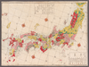
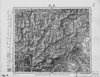
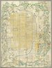
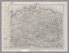
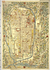
shelfmark: Maps 62980.20
License: Public Domain
文久2 *多色刷り。天保15序。(刊記書肆)文久二壬戌年十二月/発行書林/江戸、山城屋佐兵衛/京都、越後屋治兵衛/大阪、加賀屋善蔵・藤屋徳兵衛・伊丹屋善兵衛・河内屋太助・河内屋吉兵衛・河内屋喜兵衛。 Xylograph.
Links: Source / Biblio Ref
|
1862 | almost 4 years ago | 27 control points |
|
Image from the Map Collections courtesy Stanford University Libraries, licensed under a Creative Commons Attribution-Noncommercial 3.0 Unported License. © Stanford University. 【図幅名】 日奈久 【測量時期】 明治34年測圖/大正15年修正測圖/昭和7年部分修正測圖 【発行時期】 【記号】 八代六号 【測量機関】 参謀本部 【備考】 祕
Links: Source / Biblio Ref
|
over 5 years ago | 4 control points | |
|
Image from the Map Collections courtesy Stanford University Libraries, licensed under a Creative Commons Attribution-Noncommercial 3.0 Unported License. © Stanford University. 【図幅名】 日和佐 【測量時期】 明治40年測圖/昭和8年修正測圖 【発行時期】 【記号】 剣山六号 【測量機関】 参謀本部 【備考】 祕
Links: Source / Biblio Ref
|
over 5 years ago | 4 control points | |
|
Image from the Map Collections courtesy Stanford University Libraries, licensed under a Creative Commons Attribution-Noncommercial 3.0 Unported License. © Stanford University. 【図幅名】 日向青島 【測量時期】 明治35年測図/昭和7年修正/昭和10年部分修正 【発行時期】 【記号】 宮崎10号(共8面) 【測量機関】 参謀本部 【備考】 秘
Links: Source / Biblio Ref
|
about 4 years ago | 4 control points | |
|
Image from the Map Collections courtesy Stanford University Libraries, licensed under a Creative Commons Attribution-Noncommercial 3.0 Unported License. © Stanford University. 【図幅名】 富高 【測量時期】 明治35年測圖/昭和7年要部修正測圖 【発行時期】 昭和10年発行 【記号】 延岡六号 【測量機関】 大日本帝國陸地測量部 【備考】
Links: Source / Biblio Ref
|
about 4 years ago | 4 control points | |
|
Image from the Map Collections courtesy Stanford University Libraries, licensed under a Creative Commons Attribution-Noncommercial 3.0 Unported License. © Stanford University. 【図幅名】 日原 【測量時期】 明治32年測図/昭和7年要部修正 【発行時期】 昭和9年8月発行 【記号】 山口1号(共15面) 【測量機関】 大日本帝国陸地測量部 【備考】
Links: Source / Biblio Ref
|
about 2 years ago | 4 control points | |
|
Image from the Map Collections courtesy Stanford University Libraries, licensed under a Creative Commons Attribution-Noncommercial 3.0 Unported License. © Stanford University.
Links: Source / Biblio Ref
|
over 6 years ago | 4 control points | |
|
Image from the Map Collections courtesy Stanford University Libraries, licensed under a Creative Commons Attribution-Noncommercial 3.0 Unported License. © Stanford University. 【図幅名】 日光 【測量時期】 大正1年測図/昭和4年修正/昭和8年鉄道補入、測図の縮図 【発行時期】 昭和22年1月発行 【記号】 日光8号(共16面) 【測量機関】 内務省地理調査所 【備考】 (In 1 layer)
Links: Source / Biblio Ref
|
about 2 years ago | 4 control points | |
|
【最初期発行】 この地図の作成に当たっては、国土地理院長の承認を得て、同院発行の20万分の1地勢図及び5万分の1地形図を使用した。(承認番号 平30情使、 第1148号) (In 1 layer)
Links: Source / Biblio Ref
|
1921 | about 2 years ago | 4 control points |
|
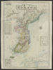
shelfmark: Maps 38.b.175
License: Public Domain
明治15 *銅板。多色刷り。英字書き入れ。赤色の線で朝鮮の旅のルートを示す。 Copperplate.
Links: Source / Biblio Ref
|
1882 | over 3 years ago | 8 control points |
|
Image from the Map Collections courtesy Stanford University Libraries, licensed under a Creative Commons Attribution-Noncommercial 3.0 Unported License. © Stanford University. 【図幅名】 新見 【測量時期】 明治31年測圖/昭和7年要部修正測圖 【発行時期】 【記号】 高梁十一号 【測量機関】 参謀本部 【備考】 祕
Links: Source / Biblio Ref
|
about 2 years ago | 4 control points | |
|
Image from the Map Collections courtesy Stanford University Libraries, licensed under a Creative Commons Attribution-Noncommercial 3.0 Unported License. © Stanford University.
Links: Source / Biblio Ref
|
over 6 years ago | 4 control points | |
|
Image from the Map Collections courtesy Stanford University Libraries. This item is in the public domain. There are no restrictions on use.
【図幅名】 新知灣 【測量時期】 大正5年測圖 【発行時期】昭和11年 【記号】 新知島十一号 【測量機関】 参謀本部【その他】千島列島 陸地測量部 (In 1 layer)
Links: Source / Biblio Ref
|
1936 | over 1 year ago | 4 control points |
|
Image from the Map Collections courtesy Stanford University Libraries. This item is in the public domain. There are no restrictions on use.
【図幅名】 新知嶽 【測量時期】 大正5年測圖 【発行時期】昭和11年 【記号】 新知島十二号 【測量機関】 参謀本部 【その他】千島列島 陸地測量部 (In 1 layer)
Links: Source / Biblio Ref
|
1936 | over 1 year ago | 4 control points |
|
Image from the Map Collections courtesy Stanford University Libraries, licensed under a Creative Commons Attribution-Noncommercial 3.0 Unported License. © Stanford University.
Links: Source / Biblio Ref
|
over 6 years ago | 4 control points | |
|
Image from the Map Collections courtesy Stanford University Libraries, licensed under a Creative Commons Attribution-Noncommercial 3.0 Unported License. © Stanford University. 【図幅名】 新発田 【測量時期】 明治44年測図/昭和6年修正 【発行時期】 【記号】 新潟9号(共16面) 【測量機関】 参謀本部 【備考】 秘
Links: Source / Biblio Ref
|
about 2 years ago | 4 control points | |
|
Image from the Map Collections courtesy Stanford University Libraries, licensed under a Creative Commons Attribution-Noncommercial 3.0 Unported License. © Stanford University. 【図幅名】 新町 【測量時期】 大正2年測図/昭和14年修正 【発行時期】 昭和16年5月発行 【記号】 秋田4号(共16面) 【測量機関】 大日本帝国陸地測量部 【備考】
Links: Source / Biblio Ref
|
about 2 years ago | 4 control points | |
|
Image from the Map Collections courtesy Stanford University Libraries, licensed under a Creative Commons Attribution-Noncommercial 3.0 Unported License. © Stanford University. 【図幅名】 新田 【測量時期】 明治39年測図/昭和8年修正 【発行時期】 昭和11年8月発行 【記号】 高知16号(共16面) 【測量機関】 大日本帝国陸地測量部 【備考】
Links: Source / Biblio Ref
|
about 2 years ago | 4 control points | |
|
Image from the Map Collections courtesy Stanford University Libraries, licensed under a Creative Commons Attribution-Noncommercial 3.0 Unported License. © Stanford University.
Links: Source / Biblio Ref
|
over 6 years ago | 4 control points | |
|
Image from the Map Collections courtesy Stanford University Libraries, licensed under a Creative Commons Attribution-Noncommercial 3.0 Unported License. © Stanford University. 【図幅名】 新潟 【測量時期】 明治44年測図/昭和6年要部修正 【発行時期】 昭和9年6月発行 【記号】 新潟13号(共16面) 【測量機関】 大日本帝国陸地測量部 【備考】
Links: Source / Biblio Ref
|
almost 4 years ago | 13 control points | |
|
【最初期発行】 この地図の作成に当たっては、国土地理院長の承認を得て、同院発行の20万分の1地勢図及び5万分の1地形図を使用した。(承認番号 平30情使、 第1148号) (In 1 layer)
Links: Source / Biblio Ref
|
1921 | about 2 years ago | 4 control points |
|
Image from the Map Collections courtesy Stanford University Libraries, licensed under a Creative Commons Attribution-Noncommercial 3.0 Unported License. © Stanford University. 【図幅名】 新津 【測量時期】 明治44年測図/昭和6年要部修正 【発行時期】 昭和9年6月発行 【記号】 新潟14号(共16面) 【測量機関】 大日本帝国陸地測量部 【備考】
Links: Source / Biblio Ref
|
about 2 years ago | 4 control points | |
|
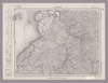
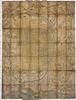
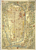
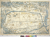
shelfmark: Or.75.f.132
License: Public Domain
貞享年間刊 *ケンペル旧蔵。無刊記。上記のOr.75.f.131と相違あり。 Xylograph; not identical to previous entry. Ex-Kaemprer. Gardner #567.
Links: Source / Biblio Ref
|
over 3 years ago | 23 control points | |
|
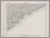
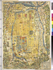
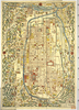
shelfmark: Or.75.f.131
License: Public Domain
貞享年間刊 *ケンペル旧蔵。無刊記。 Xylograph. Ex-Kaempfer. Gardner #566.
Links: Source / Biblio Ref
|
about 3 years ago | 24 control points | |

|
立命館大学ARC古地図データベースより引用
|
2022 | over 1 year ago | 153 control points |
|
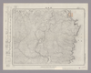
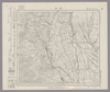
shelfmark: Or.75.f.16
License: Public Domain
貞享3 *ケンペル自筆書入あり。 Xylograph. Ex-Kaempfer. Gardner #564; Kyotozu somokuroku, p.13, #26.
Links: Source / Biblio Ref
|
1686 | over 3 years ago | 4 control points |
|
|
2017 | about 4 years ago | 6 control points |
|
Image from the Map Collections courtesy Stanford University Libraries, licensed under a Creative Commons Attribution-Noncommercial 3.0 Unported License. © Stanford University. 【図幅名】 新得 【測量時期】 大正9年測圖/昭和6年鐡道補入 【発行時期】 【記号】 夕張岳二号 【測量機関】 参謀本部 【備考】 祕 (In 1 layer)
Links: Source / Biblio Ref
|
about 2 years ago | 4 control points | |
|
Image from the Map Collections courtesy Stanford University Libraries, licensed under a Creative Commons Attribution-Noncommercial 3.0 Unported License. © Stanford University.
Links: Source / Biblio Ref
|
over 5 years ago | 4 control points | |
|
Image from the Map Collections courtesy Stanford University Libraries, licensed under a Creative Commons Attribution-Noncommercial 3.0 Unported License. © Stanford University. 【図幅名】 新庄 【測量時期】 大正2年測図/昭和9年修正 【発行時期】 昭和11年10月発行 【記号】 新庄12号(共16面) 【測量機関】 大日本帝国陸地測量部 【備考】
Links: Source / Biblio Ref
|
about 2 years ago | 4 control points | |
|
【最初期発行】 この地図の作成に当たっては、国土地理院長の承認を得て、同院発行の20万分の1地勢図及び5万分の1地形図を使用した。(承認番号 平30情使、 第1148号) (In 1 layer)
Links: Source / Biblio Ref
|
1923 | about 2 years ago | 4 control points |
|
Image from the Map Collections courtesy Stanford University Libraries, licensed under a Creative Commons Attribution-Noncommercial 3.0 Unported License. © Stanford University. 【図幅名】 新川 【測量時期】 大正10年測圖 【発行時期】 大正12年発行 【記号】 沖縄郡島三号 【測量機関】 陸地測量部・参謀本部 【備考】 軍事極祕(戦地ニ在りテハ軍事祕密トス)
Links: Source / Biblio Ref
|
3 months ago | 4 control points | |
|
この地図の作成に当たっては、国土地理院長の承認を得て、同院発行の20万分の1地勢図及び5万分の1地形図を使用した。(承認番号 平30情使、 第1148号)
Links: Source / Biblio Ref
|
1946 | over 5 years ago | 4 control points |
|
Image from the Map Collections courtesy Stanford University Libraries, licensed under a Creative Commons Attribution-Noncommercial 3.0 Unported License. © Stanford University. 【図幅名】 新居浜 【測量時期】 明治39年測図/昭和3年修正/昭和8年部分修正 【発行時期】 昭和10年11月発行 【記号】 高知9号(共16面) 【測量機関】 大日本帝国陸地測量部 【備考】 (In 1 layer)
Links: Source / Biblio Ref
|
about 2 years ago | 4 control points | |
|
この地図の作成に当たっては、国土地理院長の承認を得て、同院発行の20万分の1地勢図及び5万分の1地形図を使用した。(承認番号 平30情使、 第1148号)
Links: Source / Biblio Ref
|
1947 | over 5 years ago | 4 control points |

|
|
1863 | almost 3 years ago | 11 control points |
|
|
almost 5 years ago | 5 control points | |
|
|
1863 | almost 3 years ago | 34 control points |

|
|
1863 | over 6 years ago | 3 control points |
|
Links: Source / Biblio Ref
|
1863 | over 6 years ago | 3 control points |

|
|
1863 | over 6 years ago | 5 control points |

|
|
1863 | over 6 years ago | 4 control points |

|
GIS day ワークショップ用
|
1863 | over 6 years ago | 3 control points |

|
|
1863 | over 6 years ago | 3 control points |

|
|
1863 | over 6 years ago | 5 control points |

|
|
1863 | over 6 years ago | 4 control points |
|
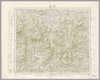
Owned by Sainsbury Institute for the Study of Japanese Arts and Cultures 【Atlas / Book Title】 【Engraver】 【Map Size】 105.5x2.0 cm 【Medium】 木版刷
Links: Source / Biblio Ref
|
1834 | almost 6 years ago | 4 control points |

|
Links: Source / Biblio Ref
|
1863 | over 6 years ago | 5 control points |
|
Owned by 立命館大学アート・リサーチセンター 【成立・出版年】 文久031863
Links: Source / Biblio Ref
|
1863 | almost 3 years ago | 29 control points |
|
Image from the Map Collections courtesy Stanford University Libraries, licensed under a Creative Commons Attribution-Noncommercial 3.0 Unported License. © Stanford University. 【図幅名】 比宇 【測量時期】 大正8年測圖 【発行時期】 【記号】 浦河九号 【測量機関】 参謀本部 【備考】 祕 (In 1 layer)
Links: Source / Biblio Ref
|
about 2 years ago | 4 control points |