Browse Maps
| map | Title | Year | Last Updated | Status  |
|---|---|---|---|---|
|
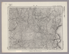
Image from the Map Collections courtesy Stanford University Libraries, licensed under a Creative Commons Attribution-Noncommercial 3.0 Unported License. © Stanford University. 【図幅名】 久遠 【測量時期】 大正6年測図 【発行時期】 大正9年1月発行 【記号】 久遠3号(共9面) 【測量機関】 大日本帝国陸地測量部 【備考】 (In 1 layer)
Links: Source / Biblio Ref
|
about 2 years ago | 4 control points | |
|
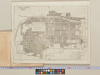
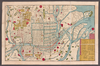
「The guide to the celebrated places in Kiyoto & the surrounding places for the foreign visitors」(同志社大学所蔵)一部です。
Links: Source / Biblio Ref
|
2024 | 4 months ago | 18 control points |
|
|
2023 | about 1 year ago | 10 control points |
|
【最初期発行】 この地図の作成に当たっては、国土地理院長の承認を得て、同院発行の20万分の1地勢図及び5万分の1地形図を使用した。(承認番号 平30情使、 第1148号) (In 1 layer)
Links: Source / Biblio Ref
|
1925 | over 2 years ago | 4 control points |
|
|
2021 | over 2 years ago | 4 control points |
|
【最初期発行】 この地図の作成に当たっては、国土地理院長の承認を得て、同院発行の20万分の1地勢図及び5万分の1地形図を使用した。(承認番号 平30情使、 第1148号) (In 1 layer)
Links: Source / Biblio Ref
|
1906 | over 2 years ago | 4 control points |
|
|
2021 | over 2 years ago | 4 control points |
|
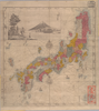
【Courtesy of the C. V. Starr East Asian Library University of California, Berkeley】 Mounted cover title. Copperplate print. In Japanese. Relief shown by hachures. Includes 1 inset, list of kokudaka and legend. Col. map folded in cover 12 x 6 cm. East Asian Library call number Cb 4.
Links: Source / Biblio Ref
|
1872 | over 3 years ago | 5 control points |
|
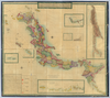
【Courtesy of the C. V. Starr East Asian Library University of California, Berkeley】 Mounted cover title. Wood block print. In Japanese. Oriented with north to the upper right. Covers Matsumae to Tsushima, Okinoerabu, and Hachijojima. Shows longitude and latitude. Shows the distance of sea routes and explanation of Kuroshio. Col. map folded in cover 19 x 10 cm. East Asian Library call number Ca30.
Links: Source / Biblio Ref
|
1843 | over 3 years ago | 5 control points |
|
【Courtesy of the C. V. Starr East Asian Library University of California, Berkeley】 Copperplate print. In Japanese. Oriented with north to the left. Relief shown pictorially. Includes distance chart and legend.
Links: Source / Biblio Ref
|
1879 | over 3 years ago | 4 control points |
|
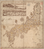
【Courtesy of the C. V. Starr East Asian Library University of California, Berkeley】 Mounted cover title. Copperplate print. In Japanese. Relief shown by hachures. Includes distance chart, 14 insets and legend. Title on map: Dai Nihon yochi zenzu. Oriented with north to the upper right. Col. map folded in envelope 15 x 8 cm. East Asian Library call number Cb57.
Links: Source / Biblio Ref
|
1877 | over 3 years ago | 5 control points |
|
【Courtesy of the C. V. Starr East Asian Library University of California, Berkeley】 Mounted cover title. Copperplate print. In Japanese. Relief shown by hachures. 14 insets: Hokkaido no zu -- Chishima Shoto no zu -- Ryukyu Hokubu Shoto zu -- Ogasawara Gunto no zu ... et al. Includes distance chart and legend. Title on map: Shinsen Dai Nihon yochi zenzu. Col. map folded in cover 16 x 9 cm. East Asian Library call number Cb83.
Links: Source / Biblio Ref
|
1885 | over 3 years ago | 5 control points |
|
|
2022 | almost 2 years ago | 5 control points |
|
【Courtesy of the C. V. Starr East Asian Library University of California, Berkeley】 Mounted cover title. Wood block print. In Japanese. Oriented with north to the upper right. Includes distance chart and legend. "Shinbun zasshi furoku". Folded in cover 13 x 8 cm. East Asian Library call number Cb6.1.
Links: Source / Biblio Ref
|
1872 | over 3 years ago | 5 control points |
|
【Courtesy of the C. V. Starr East Asian Library University of California, Berkeley】 Mounted cover title. Title on map: Kyoto sairanzu. Copperplate print. In Japanese. Oriented with north to the left. Relief shown pictorially. Includes distance chart and legend.
Links: Source / Biblio Ref
|
1881 | over 3 years ago | 4 control points |
|
【Courtesy of the C. V. Starr East Asian Library University of California, Berkeley】 Copperplate print. In Japanese. Oriented with north to the left. Relief shown pictorially. Includes text and views of tourist attractions on verso. Includes distance chart and legend.
Links: Source / Biblio Ref
|
1896 | over 3 years ago | 4 control points |
|
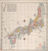
【Courtesy of the C. V. Starr East Asian Library University of California, Berkeley】 1 map : col. ; 47 x 67 cm., folded in cover 17 x 12 cm. Mounted cover title. Copperplate print. In Japanese. Oriented with north to the upper right. Relief shown by hachures. 9 insets: Hokkaido no zu.--Chosenkoku no zenzu.--Okinawa-ken Shoto no zu.--Ogasawara hoto no zu.--Chishima Shoto no zu.--Bankoku no zu ... et al.. Includes place names, charts of mountains and rivers, distance chart and views of point of interest. Includes preface and legend. Title on map: Meiji kaisei Dai Nihon meisai zenzu. East Asian Library call number: Cb86.
Links: Source / Biblio Ref
|
1886 | over 3 years ago | 5 control points |
|
【Courtesy of the C. V. Starr East Asian Library University of California, Berkeley】 Mounted cover title. Col. wood block print. In Japanese. Relief shown pictorially. Includes texts on main temples and shrines and legend. Engraved by Inoue Jihe. Folded in cover 38 x 23. East Asian Library call number: F29.
Links: Source / Biblio Ref
|
1831 | about 3 years ago | 4 control points |
|
【Courtesy of the C. V. Starr East Asian Library University of California, Berkeley】 1 map : col. ; 103 x 140 cm., folded in cover 33 x 23 cm. In Japanese. Relief shown by hachures. Oriented with north to the upper right. Includes tables of mountains, rivers, lakes. 3 insets: Chishima Shoto no zu.--Ryukyu Shoto no zu.-- Ogasawara Shoto no zu. Includes preface and legend. East Asian Library copy: Title on library's envelope: Nagasaki no zu. Mounted cover title is missing. East Asian Library call number: Cb48.
Links: Source / Biblio Ref
|
1877 | over 3 years ago | 5 control points |
|
Image from the Map Collections courtesy Stanford University Libraries, licensed under a Creative Commons Attribution-Noncommercial 3.0 Unported License. © Stanford University. 【図幅名】 江差 【測量時期】 大正6年測図 【発行時期】 大正9年2月発行 【記号】 函館13号(共14面) 【測量機関】 内務省地理調査所 【備考】 (In 1 layer)
Links: Source / Biblio Ref
|
about 2 years ago | 4 control points | |
|
【Courtesy of the C. V. Starr East Asian Library University of California, Berkeley】 Mounted cover title. Wood block print. In Japanese. Covers Matsumae to Tsushima, Okinoerabu and Okinoerabujima. 1 inset: Tokaido Fujigawa chobo. Includes latitude and longitude and explanation of Kuroshio. Shows distance of sea routes. Includes compass rose. Hand col. map folded in cover 12 x 8 cm. East Asian Library call number Ca45.
Links: Source / Biblio Ref
|
1835 | over 3 years ago | 5 control points |
|
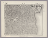
【Courtesy of the C. V. Starr East Asian Library University of California, Berkeley】 1 map : col.; 118 x 134 cm., folded in cover 32 x 21 cm. Copperplate print. In Japanese. Relief shown by hachures. Oriented with north to the right. 5 insets :Ryukyu Gunto; Hokkaido tohokugu Chupuka Gunto no zu; Ogasawara Gunto et al. Includes charts of mountains and rivers. Includes text, preface and legend. East Asian Library call number: Cb46.
Links: Source / Biblio Ref
|
1876 | over 3 years ago | 4 control points |
|
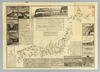
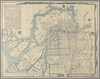
【Courtesy of the C. V. Starr East Asian Library University of California, Berkeley】 1 map ; 49 x 69 cm., folded in cover 14 x 20 cm. Cover title. Copperplate print. In Japanese. Oriented with north to the upper right. Relief shown pictorially. Includes views of points of interest, time table, fare table, freight table, railroad company names, and legend. East Asian Library call number: Cb100.
Links: Source / Biblio Ref
|
1888 | over 3 years ago | 5 control points |

|
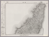
【Courtesy of the C. V. Starr East Asian Library University of California, Berkeley】 1 map : col.; 67 x 140 cm., folded in cover 25 x 17cm. Mounted cover title. Copperplate print. In Japanese. Oriented with north to the upper right. Relief shown by hachures. Includes legend and 12 insets. Title on map :Shinsen Dai Nihon kairiku zenzu : fu Chosen Ryukyu. East Asian Library call number: Cb53.
Links: Source / Biblio Ref
|
1877 | over 3 years ago | 5 control points |
|
Image from the Map Collections courtesy Stanford University Libraries, licensed under a Creative Commons Attribution-Noncommercial 3.0 Unported License. © Stanford University. 【図幅名】 宮津 【測量時期】 明治25年測図の縮図/昭和7年修正、測図の縮図/昭和25年応急修正 【発行時期】 昭和33年9月発行 【記号】 宮津15号(共12面) 【測量機関】 国土地理院 【備考】 応急修正版
Links: Source / Biblio Ref
|
about 2 years ago | 4 control points | |
|
【Courtesy of the C. V. Starr East Asian Library University of California, Berkeley】 Copperplate print. In Japanese. Covers Matsumae to Tsushima, Okinoerabujima and Ogasawara. Includes 3 insets: Tanshu Amano Hashidate fukei -- Geishu Itsukushima fukei -- Oshu Matsushima fukei. Shows the distance of sea routes. Includes longitude and latitude and explanation of Kuroshio. Includes compass rose. Folded to 29 x 9 cm., in envelope 23 x 16 cm. East Asian Library call number Ca44.
Links: Source / Biblio Ref
|
1847 | over 3 years ago | 5 control points |
|
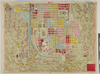
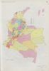
Owned by 立命館大学アート・リサーチセンター 【成立・出版年】 明治251892
Links: Source / Biblio Ref
|
1892 | about 3 years ago | 9 control points |
|
【Courtesy of the C. V. Starr East Asian Library University of California, Berkeley】 Wood block print. Preface by Shibano Ritsuzan. In Japanese. Title from: Nihon chizushi / Akioka Takejiro. p.147. Engraved by Kishimoto Hikouemon. Shows Kuroshio. Covers Matsumae to Tanegashima, Yakushima, Tsushima, and Ogasawara. Shows longitude and latitude. Includes explanation of Kuroshio. Hand col. map folded in cover 19 x 11 cm. East Asian Library call number Ca13.1.
Links: Source / Biblio Ref
|
1783 | over 3 years ago | 5 control points |
|
|
1879 | about 3 years ago | 5 control points |
|
Image from the Map Collections courtesy Stanford University Libraries, licensed under a Creative Commons Attribution-Noncommercial 3.0 Unported License. © Stanford University. 【図幅名】 梅浦 【測量時期】 明治42年測図/昭和5年修正 【発行時期】 昭和8年1月発行 【記号】 宮津1号(共12面) 【測量機関】 大日本帝国陸地測量部 【備考】
Links: Source / Biblio Ref
|
about 2 years ago | 4 control points | |
|
|
2022 | almost 2 years ago | 5 control points |
|
|
2022 | almost 2 years ago | 5 control points |
|
【Courtesy of the C. V. Starr East Asian Library University of California, Berkeley】 Copperplate print. In Japanese. Oriented with north to the left. Relief shown pictorially. Includes distance chart, index, and legend.
Links: Source / Biblio Ref
|
1879 | over 3 years ago | 4 control points |
|
|
2022 | almost 2 years ago | 5 control points |
|
【Courtesy of the C. V. Starr East Asian Library University of California, Berkeley】 Mounted cover title. Copperplate print. In Japanese. Oriented with north to the left. Relief shown pictorially. Includes legend.
Links: Source / Biblio Ref
|
1880 | over 3 years ago | 4 control points |
|
Image from the Map Collections courtesy Stanford University Libraries, licensed under a Creative Commons Attribution-Noncommercial 3.0 Unported License. © Stanford University. 【図幅名】 光 【測量時期】 明治32年測図/昭和2年修正/昭和22年応急修正 【発行時期】 昭和32年6月発行 【記号】 中津1号(共13面) 【測量機関】 国土地理院 【備考】 応急修正版
Links: Source / Biblio Ref
|
about 2 years ago | 4 control points | |
|
|
2022 | almost 2 years ago | 5 control points |
|
shelfmark: Maps 63155.5
License: Public Domain
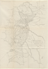
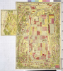
嘉永2 *多色刷り。(刊記)大坂書林/河内屋太助・河内屋政七・伊丹屋善兵衛/積典堂蔵版。 Manuscript, early 19th century. Shows the Aji river basin in and around Osaka.
Links: Source / Biblio Ref
|
1849 | about 3 years ago | 95 control points |
|
Image from the Map Collections courtesy Stanford University Libraries, licensed under a Creative Commons Attribution-Noncommercial 3.0 Unported License. © Stanford University. 【図幅名】 岩国 【測量時期】 明治27年測図の縮図/明治34年測図/昭和2年修正、測図の縮図/昭和7年鉄道補入、測図の縮図 【発行時期】 昭和22年2月発行 【記号】 広島16号(共16面) 【測量機関】 内務省地理調査所 【備考】
Links: Source / Biblio Ref
|
3 months ago | 4 control points | |
|
|
2021 | almost 3 years ago | 8 control points |
|
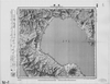
Image from the Map Collections courtesy Stanford University Libraries, licensed under a Creative Commons Attribution-Noncommercial 3.0 Unported License. © Stanford University. 【図幅名】 鷲崎 【測量時期】 大正2年測図/昭和9年修正 【発行時期】 【記号】 相川11号 【測量機関】 参謀本部 【備考】 秘
Links: Source / Biblio Ref
|
over 2 years ago | 4 control points | |
|
|
1936 | about 3 years ago | 14 control points |
|
【Courtesy of the C. V. Starr East Asian Library University of California, Berkeley】 Mounted cover title. Copperplate print. In Japanese. Oriented with north to the left. Relief shown pictorially. Includes distance chart and legend.
Links: Source / Biblio Ref
|
1880 | over 3 years ago | 4 control points |
|
この地図の作成に当たっては、国土地理院長の承認を得て、同院発行の20万分の1地勢図及び5万分の1地形図を使用した。(承認番号 平30情使、 第1148号)
Links: Source / Biblio Ref
|
1947 | about 3 years ago | 5 control points |
|
Image from the Map Collections courtesy Stanford University Libraries, licensed under a Creative Commons Attribution-Noncommercial 3.0 Unported License. © Stanford University. 【図幅名】 三段峡 【測量時期】 明治32年測図/昭和7年修正 【発行時期】 昭和10年7月発行 【記号】 広島13号(共10面) 【測量機関】 大日本帝国陸地測量部 【備考】
Links: Source / Biblio Ref
|
about 2 years ago | 4 control points | |
|
Image from the Map Collections courtesy Stanford University Libraries, licensed under a Creative Commons Attribution-Noncommercial 3.0 Unported License. © Stanford University. 【図幅名】 青森 【測量時期】 明治39年測図/大正10年測図/大正12年測図の縮図/昭和12年修正、測図の縮図/昭和34年部分修正 【発行時期】 昭和36年10月発行 【記号】 東京10号(共16面) 【測量機関】 国土地理院 【備考】 (In 1 layer)
Links: Source / Biblio Ref
|
about 2 years ago | 8 control points | |
|
Image from the Map Collections courtesy Stanford University Libraries, licensed under a Creative Commons Attribution-Noncommercial 3.0 Unported License. © Stanford University. 【図幅名】 木都賀 【測量時期】 明治32年測圖/昭和7年修正測圖 【発行時期】 【記号】 浜田十六号 【測量機関】 参謀本部 【備考】 祕
Links: Source / Biblio Ref
|
3 months ago | 4 control points | |
|
|
2022 | almost 2 years ago | 5 control points |
|
|
2022 | almost 2 years ago | 5 control points |
|
Image from the Map Collections courtesy Stanford University Libraries, licensed under a Creative Commons Attribution-Noncommercial 3.0 Unported License. © Stanford University. 【図幅名】 津田 【測量時期】 明治32年測圖/昭和2年修正測圖 【発行時期】 【記号】 広島十四号 【測量機関】 参謀本部 【備考】 祕
Links: Source / Biblio Ref
|
3 months ago | 4 control points |