Browse Maps
| map | Title | Year | Last Updated | Status  |
|---|---|---|---|---|
|
|
2022 | almost 2 years ago | 5 control points |
|
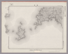
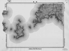
【Courtesy of the C. V. Starr East Asian Library University of California, Berkeley】 Mounted cover title. Copperplate print. In Japanese. Oriented with north to the left. Relief shown pictorially. Includes distance chart and legend.
Links: Source / Biblio Ref
|
1881 | over 3 years ago | 4 control points |
|
Image from the Map Collections courtesy Stanford University Libraries, licensed under a Creative Commons Attribution-Noncommercial 3.0 Unported License. © Stanford University. 【図幅名】 加計 【測量時期】 明治31年測図の縮図/昭和7年修正、測図の縮図 【発行時期】 昭和10年7月発行 【記号】 広島9号(共16面) 【測量機関】 大日本帝国陸地測量部 【備考】
Links: Source / Biblio Ref
|
about 2 years ago | 4 control points | |
|
Image from the Map Collections courtesy Stanford University Libraries, licensed under a Creative Commons Attribution-Noncommercial 3.0 Unported License. © Stanford University. 【図幅名】 伊予長浜 【測量時期】 明治37年測図/昭和8年修正 【発行時期】 昭和11年5月発行 【記号】 松山11号(共15面) 【測量機関】 大日本帝国陸地測量部 【備考】 (In 1 layer)
Links: Source / Biblio Ref
|
about 2 years ago | 4 control points | |
|
Image from the Map Collections courtesy Stanford University Libraries, licensed under a Creative Commons Attribution-Noncommercial 3.0 Unported License. © Stanford University. 【図幅名】 魚神山 【測量時期】 昭和8年測図の縮図/昭和20年部分修正 【発行時期】 昭和23年2月発行 【記号】 宇和島10号(共13面) 【測量機関】 地理調査所 【備考】 (In 1 layer)
Links: Source / Biblio Ref
|
about 2 years ago | 4 control points | |
|
Image from the Map Collections courtesy Stanford University Libraries, licensed under a Creative Commons Attribution-Noncommercial 3.0 Unported License. © Stanford University. 【図幅名】 可部 【測量時期】 明治31年測図の縮図/昭和7年修正、測図の縮図 【発行時期】 昭和10年7月発行 【記号】 広島5号(共10面) 【測量機関】 大日本帝国陸地測量部 【備考】
Links: Source / Biblio Ref
|
about 2 years ago | 4 control points | |
|
|
2022 | almost 2 years ago | 5 control points |
|
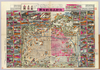
「札幌沿革史」札幌史学会 明治30所載図を拡大印刷したもの。
Links: Source / Biblio Ref
|
1897 | almost 3 years ago | 4 control points |
|
Image from the Map Collections courtesy Stanford University Libraries, licensed under a Creative Commons Attribution-Noncommercial 3.0 Unported License. © Stanford University. 【図幅名】 佐多岬 【測量時期】 明治34年測圖/昭和7年要部修正測圖/昭和10年部分修正測圖 【発行時期】 【記号】 開聞岳六号 【測量機関】 参謀本部 【備考】 祕
Links: Source / Biblio Ref
|
over 2 years ago | 4 control points | |
|
北を上に置いた地図
|
2022 | over 2 years ago | 11 control points |
|
【Courtesy of the C. V. Starr East Asian Library University of California, Berkeley】 Col. Lithograph. In Japanese and English. Oriented with north to the left. Includes a view of a temple, index and legend. Bird's eye view. Folded to 28 x 14 cm. East Asian Library call number: F150.
Links: Source / Biblio Ref
|
1868 | over 3 years ago | 4 control points |
|
国立国会図書館デジタルコレクション インターネット公開(保護期間満了)
Links: Source / Biblio Ref
|
1850 | about 3 years ago | 8 control points |
|
Image from the Map Collections courtesy Stanford University Libraries, licensed under a Creative Commons Attribution-Noncommercial 3.0 Unported License. © Stanford University. 【図幅名】 柏島 【測量時期】 明治39年測図/昭和8年修正 【発行時期】 昭和21年11月発行 【記号】 宇和島8号(共13面) 【測量機関】 地理調査所 【備考】
Links: Source / Biblio Ref
|
about 2 years ago | 4 control points | |
|
Links: Source / Biblio Ref
|
2021 | almost 3 years ago | 5 control points |
|
Image from the Map Collections courtesy Stanford University Libraries, licensed under a Creative Commons Attribution-Noncommercial 3.0 Unported License. © Stanford University. 【図幅名】 大分 【測量時期】 明治36年測図/昭和2年第2回修正、測図の縮図/昭和15年部分修正、測図の縮図/昭和23年資料修正 【発行時期】 昭和25年10月発行 【記号】 大分5号 【測量機関】 地理調査所 【備考】
Links: Source / Biblio Ref
|
over 2 years ago | 4 control points | |
|
Image from the Map Collections courtesy Stanford University Libraries, licensed under a Creative Commons Attribution-Noncommercial 3.0 Unported License. © Stanford University. 【図幅名】 伊予高山 【測量時期】 明治37年測図/昭和8年修正/昭和20年部分修正 【発行時期】 昭和23年2月発行 【記号】 宇和島9号(共13面) 【測量機関】 地理調査所 【備考】 (In 1 layer)
Links: Source / Biblio Ref
|
about 2 years ago | 4 control points | |
|
この地図の作成に当たっては、国土地理院長の承認を得て、同院発行の20万分の1地勢図及び5万分の1地形図を使用した。(承認番号 平30情使、 第1148号)
Links: Source / Biblio Ref
|
1946 | over 2 years ago | 4 control points |
|
|
2023 | about 1 year ago | 8 control points |
|
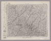
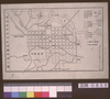
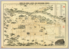
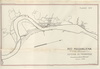
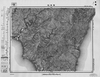
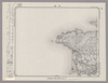
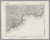
RIO MAGDALENA. PARA ACOMPAÑAR AL INFORME DE SIR. A.GIBB G.B.C G.B. 14 DE JULIO DE 1930. DEFENSA DE MAGANGUE. PLANO Nº7.
|
1930 | 8 months ago | 43 control points |
|
Links: Source / Biblio Ref
|
2022 | over 2 years ago | 4 control points |
|
この地図の作成に当たっては、国土地理院長の承認を得て、同院発行の20万分の1地勢図及び5万分の1地形図を使用した。(承認番号 平30情使、 第1148号)
Links: Source / Biblio Ref
|
1947 | about 2 years ago | 4 control points |
|
Image from the Map Collections courtesy Stanford University Libraries, licensed under a Creative Commons Attribution-Noncommercial 3.0 Unported License. © Stanford University. 【図幅名】 浦郷 【測量時期】 大正1年測図/昭和9年修正/昭和28年応急修正 【発行時期】 昭和28年8月発行 【記号】 西郷16号西部(共4面) 【測量機関】 国土地理院 【備考】 応急修正版
Links: Source / Biblio Ref
|
about 2 years ago | 4 control points | |
|
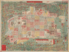
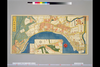
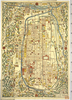
Owned by 立命館大学アート・リサーチセンター 【成立・出版年】 文久031863
Links: Source / Biblio Ref
|
1863 | about 3 years ago | 29 control points |
|
【Courtesy of the C. V. Starr East Asian Library University of California, Berkeley】 Col. Lithograph. In Japanese. Oriented with north to the left. Relief shown pictorially. Shows views of tourist attractions. Includes distance chart, preface and legend. Folded in cover 28 x 20 cm. East Asian Library call number: F139.1.
Links: Source / Biblio Ref
|
1908 | over 3 years ago | 4 control points |
|
Image from the Map Collections courtesy Stanford University Libraries, licensed under a Creative Commons Attribution-Noncommercial 3.0 Unported License. © Stanford University. 【図幅名】 今市 【測量時期】 明治32年測図/昭和9年修正、測図の縮図 【発行時期】 昭和12年3月発行 【記号】 大社4号(共3面) 【測量機関】 大日本帝国陸地測量部 【備考】
Links: Source / Biblio Ref
|
about 2 years ago | 4 control points | |
|
Image from the Map Collections courtesy Stanford University Libraries, licensed under a Creative Commons Attribution-Noncommercial 3.0 Unported License. © Stanford University. 【図幅名】 今治西部 【測量時期】 明治31年測図/昭和3年修正 【発行時期】 昭和6年6月発行 【記号】 広島4号(共16面) 【測量機関】 大日本帝国陸地測量部 【備考】 (In 1 layer)
Links: Source / Biblio Ref
|
about 2 years ago | 4 control points | |
|
Image from the Map Collections courtesy Stanford University Libraries, licensed under a Creative Commons Attribution-Noncommercial 3.0 Unported License. © Stanford University. 【図幅名】 万場 【測量時期】 大正1年測図/昭和9年要部修正 【発行時期】 昭和15年7月発行 【記号】 長野4号(共16面) 【測量機関】 大日本帝国陸地測量部 【備考】
Links: Source / Biblio Ref
|
about 2 years ago | 4 control points | |
|
Links: Source / Biblio Ref
|
2021 | over 2 years ago | 25 control points |
|
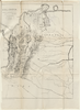
【Courtesy of the C. V. Starr East Asian Library University of California, Berkeley】 Title added by hand. Copperplate print. In Japanese. Oriented with north to the left. Relief shown pictorially. Includes legend. Folded in cover 33 x 21 cm. East Asian Library call number: F56.
Links: Source / Biblio Ref
|
1868 | over 3 years ago | 4 control points |
|
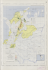
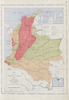
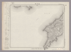
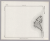
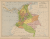
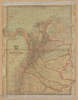
Mapa geopolítico de Colombia 1930
|
1930 | over 2 years ago | 12 control points |
|
Image from the Map Collections courtesy Stanford University Libraries, licensed under a Creative Commons Attribution-Noncommercial 3.0 Unported License. © Stanford University. 【図幅名】 岩松 【測量時期】 明治37年測図/昭和8年修正 【発行時期】 昭和11年6月発行 【記号】 宇和島6号(共13面) 【測量機関】 大日本帝国陸地測量部 【備考】 (In 1 layer)
Links: Source / Biblio Ref
|
5 months ago | 4 control points | |
|
Image from the Map Collections courtesy Stanford University Libraries, licensed under a Creative Commons Attribution-Noncommercial 3.0 Unported License. © Stanford University. 【図幅名】 大社 【測量時期】 明治32年測図/昭和9年第2回修正、測図の縮図 【発行時期】 【記号】 大社8号(共3面) 【測量機関】 参謀本部 【備考】 秘
Links: Source / Biblio Ref
|
about 2 years ago | 4 control points | |
|
Image from the Map Collections courtesy Stanford University Libraries, licensed under a Creative Commons Attribution-Noncommercial 3.0 Unported License. © Stanford University. 【図幅名】 頓原 【測量時期】 明治32年測図/昭和7年修正 【発行時期】 昭和10年6月発行 【記号】 浜田2号(共15面) 【測量機関】 大日本帝国陸地測量部 【備考】
Links: Source / Biblio Ref
|
about 2 years ago | 4 control points | |
|
Image from the Map Collections courtesy Stanford University Libraries, licensed under a Creative Commons Attribution-Noncommercial 3.0 Unported License. © Stanford University. 【図幅名】 三峰 【測量時期】 明治43年測図/昭和4年要部修正 【発行時期】 昭和7年3月発行 【記号】 甲府1号(共16面) 【測量機関】 大日本帝国陸地測量部 【備考】 (In 1 layer)
Links: Source / Biblio Ref
|
about 2 years ago | 4 control points | |
|
この地図の作成に当たっては、国土地理院長の承認を得て、同院発行の20万分の1地勢図及び5万分の1地形図を使用した。(承認番号 平30情使、 第1148号)
Links: Source / Biblio Ref
|
1947 | over 2 years ago | 4 control points |
|
Image from the Map Collections courtesy Stanford University Libraries, licensed under a Creative Commons Attribution-Noncommercial 3.0 Unported License. © Stanford University. 【図幅名】 御殿場 【測量時期】 明治19年測図の縮図/大正4年修正、測図の縮図/昭和7年第3回部分修正、測図の縮図 【発行時期】 昭和21年11月発行 【記号】 静岡1号(共15面) 【測量機関】 内務省地理調査所 【備考】 (In 1 layer)
Links: Source / Biblio Ref
|
about 2 years ago | 4 control points | |
|
Mapa geopolítico de Colombia 1930
|
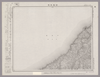
1913 | over 2 years ago | 7 control points |
|
【Courtesy of the C. V. Starr East Asian Library University of California, Berkeley】 Cover title. Lithograph. In Japanese. Oriented with north to the left. Relief shown pictorially. Includes distance chart and list addresses on verso. Title on map: Kyoto shigai meisai chizu.
Links: Source / Biblio Ref
|
1905 | over 3 years ago | 4 control points |

|
|
1863 | about 3 years ago | 11 control points |
|
Image from the Map Collections courtesy Stanford University Libraries, licensed under a Creative Commons Attribution-Noncommercial 3.0 Unported License. © Stanford University. 【図幅名】 横田 【測量時期】 明治32年測圖/昭和7年要部修正測圖 【発行時期】 【記号】 高梁十三号 【測量機関】 参謀本部 【備考】 祕
Links: Source / Biblio Ref
|
about 2 years ago | 4 control points | |
|
Image from the Map Collections courtesy Stanford University Libraries, licensed under a Creative Commons Attribution-Noncommercial 3.0 Unported License. © Stanford University. 【図幅名】 鴨川 【測量時期】 明治36年測図/昭和6年修正 【発行時期】 昭和8年2月発行 【記号】 大多喜14号(共4面) 【測量機関】 大日本帝国陸地測量部 【備考】 (In 1 layer)
Links: Source / Biblio Ref
|
about 2 years ago | 4 control points | |
|
この地図の作成に当たっては、国土地理院長の承認を得て、同院発行の20万分の1地勢図及び5万分の1地形図を使用した。(承認番号 平30情使、 第1148号)
Links: Source / Biblio Ref
|
1947 | over 2 years ago | 4 control points |
|
Image from the Map Collections courtesy Stanford University Libraries, licensed under a Creative Commons Attribution-Noncommercial 3.0 Unported License. © Stanford University. 【図幅名】 姉崎 【測量時期】 明治36年測図/昭和6年修正 【発行時期】 昭和16年10月発行 【記号】 佐倉16号(共12面) 【測量機関】 大日本帝国陸地測量部 【備考】 (In 1 layer)
Links: Source / Biblio Ref
|
about 2 years ago | 4 control points | |
|
Image from the Map Collections courtesy Stanford University Libraries, licensed under a Creative Commons Attribution-Noncommercial 3.0 Unported License. © Stanford University. 【図幅名】 東京東北部 【測量時期】 明治42年測図/大正10年第2回修正/昭和4年測図/昭和7年要部修正 【発行時期】 昭和7年12月発行 【記号】 東京2号 【測量機関】 大日本帝国陸地測量部 【備考】 (In 1 layer)
Links: Source / Biblio Ref
|
about 2 years ago | 4 control points | |
|
Image from the Map Collections courtesy Stanford University Libraries, licensed under a Creative Commons Attribution-Noncommercial 3.0 Unported License. © Stanford University. 【図幅名】 横浜 【測量時期】 明治39年測図/昭和7年測図の縮図、第2回修正、測図の縮図 【発行時期】 昭和21年8月発行 【記号】 東京8号 【測量機関】 内務省地理調査所 【備考】 (In 1 layer)
Links: Source / Biblio Ref
|
3 months ago | 4 control points | |
|
|
2023 | about 1 year ago | 4 control points |
|
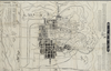
【Courtesy of the C. V. Starr East Asian Library University of California, Berkeley】 Title on envelope: Kyoto-shi oyobi Yamashiro hachigun sokuryo meisai chizu. Lithograph. In Japanese. Relief shown by hachures. Includes text on verso. Includes 1 map on verso: Yamashiro zenzu. Includes index.
Links: Source / Biblio Ref
|
1903 | over 3 years ago | 4 control points |
|
Image from the Map Collections courtesy Stanford University Libraries, licensed under a Creative Commons Attribution-Noncommercial 3.0 Unported License. © Stanford University. 【図幅名】 多里 【測量時期】 明治32年測圖/昭和7年要部修正測圖 【発行時期】 【記号】 高梁十四号 【測量機関】 参謀本部 【備考】 祕
Links: Source / Biblio Ref
|
about 2 years ago | 4 control points | |
|
Image from the Map Collections courtesy Stanford University Libraries, licensed under a Creative Commons Attribution-Noncommercial 3.0 Unported License. © Stanford University. 【図幅名】 高崎 【測量時期】 明治40年測図/昭和4年修正/昭和9年要部修正 【発行時期】 昭和21年12月発行 【記号】 宇都宮15号(共16面) 【測量機関】 内務省地理調査所 【備考】 (In 1 layer)
Links: Source / Biblio Ref
|
about 2 years ago | 4 control points | |
|
この地図の作成に当たっては、国土地理院長の承認を得て、同院発行の20万分の1地勢図及び5万分の1地形図を使用した。(承認番号 平30情使、 第1148号) (In 2 layers)
Links: Source / Biblio Ref
|
1947 | about 2 years ago | 4 control points |