Browse Maps
| map | Title | Year | Last Updated  |
Status |
|---|---|---|---|---|
|
Links: Source / Biblio Ref
|
2020 | almost 4 years ago | Unrectified |
|
Links: Source / Biblio Ref
|
2020 | almost 4 years ago | Unrectified |
|
Links: Source / Biblio Ref
|
2020 | almost 4 years ago | Unrectified |
|
Links: Source / Biblio Ref
|
2020 | almost 4 years ago | Unrectified |
|
Links: Source / Biblio Ref
|
2020 | almost 4 years ago | Unrectified |
|
|
2020 | almost 4 years ago | 3 control points |
|
Links: Source / Biblio Ref
|
2020 | almost 4 years ago | Unrectified |
|
Links: Source / Biblio Ref
|
2020 | almost 4 years ago | Unrectified |
|
Links: Source / Biblio Ref
|
2020 | almost 4 years ago | Unrectified |
|
|
2020 | almost 4 years ago | 5 control points |
|
Image from the Map Collections courtesy Stanford University Libraries, licensed under a Creative Commons Attribution-Noncommercial 3.0 Unported License. © Stanford University. 【図幅名】 新潟 【測量時期】 明治44年測図/昭和6年要部修正 【発行時期】 昭和9年6月発行 【記号】 新潟13号(共16面) 【測量機関】 大日本帝国陸地測量部 【備考】
Links: Source / Biblio Ref
|
almost 4 years ago | 13 control points | |
|
Links: Source / Biblio Ref
|
2020 | almost 4 years ago | Unrectified |
|
Links: Source / Biblio Ref
|
2020 | almost 4 years ago | Unrectified |
|
Links: Source / Biblio Ref
|
2020 | almost 4 years ago | Unrectified |
|
shelfmark: Maps 38.c.218
License: Public Domain
天保14 *無刊記。外題「(富士見十三州)輿地之全図」。江戸湾に「御台場」あり。凡例末を入れ木して「故名焉」と改む。左下欄外に「木邨嘉平刻」とあり。 Xylograph.
Links: Source / Biblio Ref
|
1843 | almost 4 years ago | 32 control points |
|
Links: Source / Biblio Ref
|
2020 | almost 4 years ago | Unrectified |
|
Links: Source / Biblio Ref
|
2020 | almost 4 years ago | Unrectified |
|
|
2020 | almost 4 years ago | 3 control points |
|
Links: Source / Biblio Ref
|
2020 | almost 4 years ago | Unrectified |
|
Links: Source / Biblio Ref
|
2020 | almost 4 years ago | Unrectified |
|
|
2020 | almost 4 years ago | 4 control points |
|
Links: Source / Biblio Ref
|
2020 | almost 4 years ago | Unrectified |
|
Links: Source / Biblio Ref
|
2020 | almost 4 years ago | Unrectified |
|
Links: Source / Biblio Ref
|
2020 | almost 4 years ago | Unrectified |
|
Links: Source / Biblio Ref
|
2020 | almost 4 years ago | Unrectified |
|
Links: Source / Biblio Ref
|
2020 | almost 4 years ago | Unrectified |
|
Links: Source / Biblio Ref
|
2020 | almost 4 years ago | Unrectified |
|
Links: Source / Biblio Ref
|
2020 | almost 4 years ago | Unrectified |
|
Links: Source / Biblio Ref
|
2020 | almost 4 years ago | Unrectified |
|
Links: Source / Biblio Ref
|
2020 | almost 4 years ago | Unrectified |
|
Links: Source / Biblio Ref
|
2020 | almost 4 years ago | Unrectified |
|
Links: Source / Biblio Ref
|
2020 | almost 4 years ago | Unrectified |
|
Links: Source / Biblio Ref
|
2020 | almost 4 years ago | Unrectified |
|
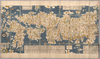
【Courtesy of the C. V. Starr East Asian Library University of California, Berkeley】 Japanese date Genroku 4 1691. In color. Folded. Wood block print. In Japanese. Title from: Nihon kohan chizu shūsei / Kurita Mototsugu. p.34. Covers Matsumae to Ryūkyū and Tsushima. Shows points of interest pictorially. Includes lists of main shrines and place names, seasonal diagrams, distance charts and legend. Shows daimyo and kokudaka.
Links: Source / Biblio Ref
|
1691 | almost 4 years ago | 37 control points |
|
shelfmark: Maps 38.c.211
License: Public Domain
嘉永6 *多色刷り。存原外袋。(刊記)蔦屋吉蔵寿梓。刊年は外袋に「(安政改正)宝永御江戸絵図/地本草紙問屋東都紅英堂上梓」とあるによる。外袋に書名が「ほうえいおんえどゑず」と振ってある。 Xylograph. Edozu somokuroku, p.166.
Links: Source / Biblio Ref
|
1853 | almost 4 years ago | 12 control points |
|
shelfmark: Maps 38.b.164
License: Public Domain
明治5 *銅板。多色刷り。外題「(銅刻)大日本改正輿地全図」。北海道・樺太・千島列島等を含む。(刊記)免許文化八辛未年七月/再刻天保八丁酉年九月/三刻天保十四癸卯年九月/四刻慶応三丁卯八月/五刻明治五壬申年十一月銅刻/東京書肆玉養堂若林喜兵衛蔵板。(枠外)木村楊堂縮写並銅鐫。 Copperplate.
Links: Source / Biblio Ref
|
1872 | almost 4 years ago | 16 control points |
|
shelfmark: Maps 62980.20
License: Public Domain
文久2 *多色刷り。天保15序。(刊記書肆)文久二壬戌年十二月/発行書林/江戸、山城屋佐兵衛/京都、越後屋治兵衛/大阪、加賀屋善蔵・藤屋徳兵衛・伊丹屋善兵衛・河内屋太助・河内屋吉兵衛・河内屋喜兵衛。 Xylograph.
Links: Source / Biblio Ref
|
1862 | almost 4 years ago | 27 control points |
|
二十万分の一
|
almost 4 years ago | 10 control points | |
|
shelfmark: Maps 145.d.279
License: Public Domain
嘉永3 *多色刷り。『江戸切絵図集成』第四巻所収の嘉永3訂・図に該当。外題「駿河台小川町絵図」。初版図の刊年が嘉永3となっているが、本図の刊記は「嘉永二己酉年新刻/安政七庚申年改」。英数字・片仮名書き入れ多し。 Xylograph. Acquired 22 July 1868. Ex-Siebold. Edo kiriezu shusei 4: 40-45
Links: Source / Biblio Ref
|
1850 | almost 4 years ago | 9 control points |
|
【最初期発行】 この地図の作成に当たっては、国土地理院長の承認を得て、同院発行の20万分の1地勢図及び5万分の1地形図を使用した。(承認番号 平30情使、 第1148号) (In 1 layer)
Links: Source / Biblio Ref
|
1922 | almost 4 years ago | 4 control points |
|
Links: Source / Biblio Ref
|
2020 | almost 4 years ago | Unrectified |
|
Links: Source / Biblio Ref
|
2020 | almost 4 years ago | Unrectified |
|
Links: Source / Biblio Ref
|
2020 | almost 4 years ago | Unrectified |
|
Links: Source / Biblio Ref
|
2020 | almost 4 years ago | Unrectified |
|
Links: Source / Biblio Ref
|
2020 | almost 4 years ago | Unrectified |
|
Links: Source / Biblio Ref
|
2020 | almost 4 years ago | Unrectified |
|
Links: Source / Biblio Ref
|
2020 | almost 4 years ago | Unrectified |
|
Links: Source / Biblio Ref
|
2020 | almost 4 years ago | Unrectified |
|
Links: Source / Biblio Ref
|
2020 | almost 4 years ago | Unrectified |
|
Links: Source / Biblio Ref
|
2020 | almost 4 years ago | Unrectified |