Browse Maps
| map | Title | Year | Last Updated  |
Status |
|---|---|---|---|---|
|
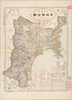
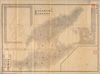
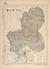
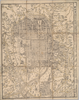
【Courtesy of the C. V. Starr East Asian Library University of California, Berkeley】 Title on enevelope: Saishin Miyagi-ken zenzu. In Japanese. Relief shown by hachures.
Links: Source / Biblio Ref
|
1907 | over 5 years ago | 4 control points |
|
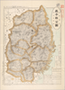
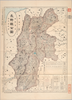
【Courtesy of the C. V. Starr East Asian Library University of California, Berkeley】 Title on envelope: Saishin Iwate-ken zenzu. In Japanese. Relief shown by hachures. Includes list of addresses and legend. Shows the sea routes with distances.
Links: Source / Biblio Ref
|
1908 | over 5 years ago | 4 control points |
|
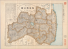
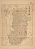
【Courtesy of the C. V. Starr East Asian Library University of California, Berkeley】 Title on envelope: Saishin Fukushima-ken zenzu. In Japanese. Relief shown by hachures.
Links: Source / Biblio Ref
|
1907 | over 5 years ago | 4 control points |
|
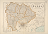
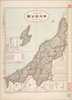
【Courtesy of the C. V. Starr East Asian Library University of California, Berkeley】 Title on envelope: Saishin Yamanashi-ken zenzu. In Japanese. Relief shown by hachures. Includes list of addresses and legend.
Links: Source / Biblio Ref
|
1907 | over 5 years ago | 4 control points |
|
【Courtesy of the C. V. Starr East Asian Library University of California, Berkeley】 Title on envelope: Saishin Aichi-ken zenzu. In Japanese. Relief shown by hachures. Includes list of addresses and legend. Shows distance of sea routes.
Links: Source / Biblio Ref
|
1907 | over 5 years ago | 4 control points |
|
【Courtesy of the C. V. Starr East Asian Library University of California, Berkeley】 Title on envelope: Saishin Shizuoka-ken zenzu. In Japanese. Relief shown by hachures. Includes list of addresses and legend. Shows distance of sea routes.
Links: Source / Biblio Ref
|
1907 | over 5 years ago | 4 control points |
|
【Courtesy of the C. V. Starr East Asian Library University of California, Berkeley】 Title on envelope: Saishin Akita-ken zenzu. In Japanese. Relief shown by hachures. Includes list of addresses and legend. Shows the sea routes with distances.
Links: Source / Biblio Ref
|
1908 | over 5 years ago | 4 control points |
|
【Courtesy of the C. V. Starr East Asian Library University of California, Berkeley】 Title on envelope: Saishin Ibaraki-ken zenzu. In Japanese. Relief shown by hachures. Includes list of addresses and legend.
Links: Source / Biblio Ref
|
1907 | over 5 years ago | 4 control points |
|
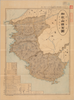
【Courtesy of the C. V. Starr East Asian Library University of California, Berkeley】 In Japanese. Oriented with north to the upper left. Relief shown by hachures. Includes 5 insets and legend. Includes text on districts and distance chart on verso.
Links: Source / Biblio Ref
|
1903 | over 5 years ago | 4 control points |
|
【Courtesy of the C. V. Starr East Asian Library University of California, Berkeley】 In Japanese. Oriented with north to the upper left. Relief shown by hachures. Includes 3 insets and legend. Includes distance chart and text on districts on verso.
Links: Source / Biblio Ref
|
1903 | over 5 years ago | 4 control points |
|
【Courtesy of the C. V. Starr East Asian Library University of California, Berkeley】 Lithograph. Relief shown by hachures. Includes 3 insets and legend. Includes distance chart and text on districts on verso. In Japanese.
Links: Source / Biblio Ref
|
1909 | over 5 years ago | 4 control points |
|
【Courtesy of the C. V. Starr East Asian Library University of California, Berkeley】 Oriented with north to the upper left. In Japanese. Relief shown by hachures. Includes 5 insets and legend. Includes distance chart and text on districts on verso.
Links: Source / Biblio Ref
|
1903 | over 5 years ago | 4 control points |
|
【Courtesy of the C. V. Starr East Asian Library University of California, Berkeley】 Mounted cover title. Title on map: Fukui-ken kannai chizu. Wood block print. In Japanese. Relief shown by hachures.
Links: Source / Biblio Ref
|
1883 | over 5 years ago | 4 control points |
|
【Courtesy of the C. V. Starr East Asian Library University of California, Berkeley】 Copperplate print. In Japanese. Relief shown by hachures. Includes legend.
Links: Source / Biblio Ref
|
1886 | over 5 years ago | 4 control points |
|
【Courtesy of the C. V. Starr East Asian Library University of California, Berkeley】 Mounted cover title. In Japanese. Copperplate print. Relief shown by hachures. Includes preface and legend.
Links: Source / Biblio Ref
|
1878 | over 5 years ago | 4 control points |
|
【Courtesy of the C. V. Starr East Asian Library University of California, Berkeley】 Mounted cover title. In Japanese. Copperplate print. Relief shown by hachures. Title on map :Shiga-ken kannai chiri yakuzu. Includes legend.
Links: Source / Biblio Ref
|
1879 | over 5 years ago | 4 control points |

|
【Courtesy of the C. V. Starr East Asian Library University of California, Berkeley】 Lithograph. In Japanese. Oriented with north to the left. Relief shown by hachures. Includes 1 inset : Otsu shigai chizu. Includes distance charts and legend. Includes views of tourist attractions on verso.
Links: Source / Biblio Ref
|
1903 | over 5 years ago | 4 control points |
|
【Courtesy of the C. V. Starr East Asian Library University of California, Berkeley】 Mounted cover title. Title on map: Jichikubetsu kaisei Sado zenzu. Lithograph. In Japanese. Oriented with north to the upper right. Relief shown by hachures. Includes 3 insets and legend.
Links: Source / Biblio Ref
|
1894 | over 5 years ago | 4 control points |
|
【Courtesy of the C. V. Starr East Asian Library University of California, Berkeley】 Title on envelope: Saishin Wakayama-ken zenzu. In Japanese. Relief shown by hachures. Includes list of addresses and legend.
Links: Source / Biblio Ref
|
1908 | over 5 years ago | 4 control points |
|
【Courtesy of the C. V. Starr East Asian Library University of California, Berkeley】 Lithograph, col. In Japanese. Oriented with north to the right. Relief shown by hachures. Includes inset: Saishin Yokohama zu. Includes legend. Includes list of points of interest and a map of railroad lines on verso. Folded to 28 x 14 cm. East Asian Library call number: Eb201.
Links: Source / Biblio Ref
|
1910 | over 5 years ago | 4 control points |
|
【Courtesy of the C. V. Starr East Asian Library University of California, Berkeley】 Lithograph. In Japanese. Relief shown by hachures. Includes legend.
Links: Source / Biblio Ref
|
1897 | over 5 years ago | 4 control points |
|
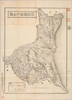
【Courtesy of the C. V. Starr East Asian Library University of California, Berkeley】 Title on envelope: Saishin Gifu-ken zenzu. In Japanese. Relief shown by hachures. Includes address chart and legend.
Links: Source / Biblio Ref
|
1907 | over 5 years ago | 4 control points |
|
【Courtesy of the C. V. Starr East Asian Library University of California, Berkeley】 Title on envelope: Saishin Nagano-ken zenzu. In Japanese. Relief shown by hachures. Includes address chart and legend.
Links: Source / Biblio Ref
|
1907 | over 5 years ago | 4 control points |
|
【Courtesy of the C. V. Starr East Asian Library University of California, Berkeley】 Title on envelope :Saishin Nara-ken zenzu. In Japanese. Relief shown by hachures and spot heights. Includes list of addresses and legend.
Links: Source / Biblio Ref
|
1908 | over 5 years ago | 4 control points |
|
【Courtesy of the C. V. Starr East Asian Library University of California, Berkeley】 Title on envelope: Saishin Niigata-ken zenzu. In Japanese. Relief shown by hachures. Includes list of addresses and legend. Shows distance of sea routes.
Links: Source / Biblio Ref
|
1907 | over 5 years ago | 4 control points |
|
【Courtesy of the C. V. Starr East Asian Library University of California, Berkeley】 Title on envelope : Saishin Mie-ken zenzu. In Japanese. Relief shown by hachures. Includes list of addresses and legend. Shows distance of sea routes.
Links: Source / Biblio Ref
|
1907 | over 5 years ago | 4 control points |
|
【Courtesy of the C. V. Starr East Asian Library University of California, Berkeley】 Title on envelope: Saishin Shiga-ken zenzu. Relief shown by hachures. Includes list of addresses and legend. In Japanese.
Links: Source / Biblio Ref
|
1908 | over 5 years ago | 4 control points |
|
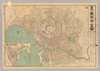
【Courtesy of the C. V. Starr East Asian Library University of California, Berkeley】 Mounted cover title. Title on map: Meisho eiri Tokyo shinzu. Copperplate print. In Japanese. Oriented with north to the right. Includes address chart and distance chart. Shows points of interest pictorially. Shows views of attractions.
Links: Source / Biblio Ref
|
1883 | over 5 years ago | 4 control points |
|
【Courtesy of the C. V. Starr East Asian Library University of California, Berkeley】 Cover title. Title on map: Meiji kaisei Tokyo zenzu. Copperplate print. In Japanese. Oriented with north to the right. Relief shown by hachures. Includes address charts, guide for tourist, time table and legend. Shows views of tourist attractions.
Links: Source / Biblio Ref
|
1888 | over 5 years ago | 4 control points |
|
【Courtesy of the C. V. Starr East Asian Library University of California, Berkeley】 Mounted cover title. Copperplate print. In Japanese. Oriented with north to the upper right. Includes address chart pasted on the bottom of map. Includes legend.
Links: Source / Biblio Ref
|
1880 | over 5 years ago | 4 control points |
|
【Courtesy of the C. V. Starr East Asian Library University of California, Berkeley】 Mounted cover title. Lithograph. In Japanese. Relief shown by hachures. Includes 3 insets, distance chart, and legend.
Links: Source / Biblio Ref
|
1877 | over 5 years ago | 4 control points |
|
【Courtesy of the C. V. Starr East Asian Library University of California, Berkeley】 In Japanese. Relief shown by hachures. Includes advertisement on verso. Oriented with north to the right. Includes legend.
Links: Source / Biblio Ref
|
1907 | over 5 years ago | 4 control points |
|
【Courtesy of the C. V. Starr East Asian Library University of California, Berkeley】 Copperplate print. In Japanese. Oriented with north to the upper right. Relief shown by hachures. 7 insets: Hokkaido zenbu -- Chishima zenbu -- Osumi Shichito Okinawa Shoto ... et al.. Includes views of points of interest, charts of mountains and rivers, list of prefectures, and legend. Shows sea routes with distance. In color, folded to 18 x 13 cm. East Asian Library call number: Cb110.
Links: Source / Biblio Ref
|
1891 | over 5 years ago | 5 control points |
|
【Courtesy of the C. V. Starr East Asian Library University of California, Berkeley】 Mounted cover title. Copperplate print. In Japanese. Oriented with north to the upper right. Relief shown by hachures. 4 insets: Hokkaido zenzu ; Ryukyu Shoto no zu ; Chishima Shoto et al.. Includes charts of mountains and rivers, distance chart, and legend. Shows flags. In color, folded in cover 18 x 12 cm. East Asian Library call number: Cb129.
Links: Source / Biblio Ref
|
1893 | over 5 years ago | 4 control points |
|
【Courtesy of the C. V. Starr East Asian Library University of California, Berkeley】 Lithograph. In Japanese. Oriented with north to the upper right. Relief shown by hachures. Includes 7 insets: Saikaido -- Osumi oyobi Ryukyu Shoto -- Hokkaido no zu ... et al.. Includes 19 city maps and distance chart on verso. Includes legend. In color. Folded in cover 14 x 11 cm. East Asian Library call number: Cb143.
Links: Source / Biblio Ref
|
1899 | over 5 years ago | 4 control points |
|
【Courtesy of the C. V. Starr East Asian Library University of California, Berkeley】 Lithograph. In Japanese. Oriented with north to the upper right. Relief shown by hachures. Includes 5 insets: Shinryochi Taiwanto -- Hokkaido -- Seinanbu Shoto ... et al.. Shows sea routes. Includes legend. In color. Folded in cover 19 x 14 cm. East Asian Library call number: Cb147.
Links: Source / Biblio Ref
|
1899 | over 5 years ago | 5 control points |
|
【Courtesy of the C. V. Starr East Asian Library University of California, Berkeley】 Mounted cover title. Wood block print. Hand col. In Japanese. Relief shown pictorially. Includes distance chart and index. Folded in cover 24 x 16 cm. East Asian Library call number: F1.
Links: Source / Biblio Ref
|
1724 | over 5 years ago | 4 control points |
|
【Courtesy of the C. V. Starr East Asian Library University of California, Berkeley】 Cover title. Wood block print. In Japanese. Oriented with north to the left. Relief shown pictorially. Includes distance chart and seasonal tides. Folded in envelope 16 x 8 cm. East Asian Library call number: F22.
Links: Source / Biblio Ref
|
1811 | over 5 years ago | 4 control points |
|
【Courtesy of the C. V. Starr East Asian Library University of California, Berkeley】 Mounted cover title. Wood block print. Hand col. In Japanese. Relief shown pictorially. Includes distance chart and index. Includes text on main temples and shrines. Folded to 24 x 16 cm. East Asian Library call number: F4.1.
Links: Source / Biblio Ref
|
1709 | over 5 years ago | 4 control points |
|
【Courtesy of the C. V. Starr East Asian Library University of California, Berkeley】 Title added by hand. Wood block print. In Japanese. Oriented with north to the left. Relief shown pictorially. Includes index. Folded to 18 x 14 cm. East Asian Library call number: F57.
Links: Source / Biblio Ref
|
1869 | over 5 years ago | 4 control points |
|
【Courtesy of the C. V. Starr East Asian Library University of California, Berkeley】 Mounted cover title. Title on map: Kyoto ku kumi meisaizu. Copperplate print, col. In Japanese. Oriented with north to the left. Relief shown pictorially. Includes distance chart, index, and legend. Folded in cover 17 x 12 cm. East Asian Library call number: F87.
Links: Source / Biblio Ref
|
1889 | over 5 years ago | 4 control points |
|
【Courtesy of the C. V. Starr East Asian Library University of California, Berkeley】 Mounted cover title. Copperplate print. In Japanese. Orientation varies. Relief shown pictorially. Shows distance of roads and sea routes. Shows views of tourist attractions. Includes legend. Folded in cover 18 x 10 cm. East Asian Library call number: J32.
Links: Source / Biblio Ref
|
1881 | over 5 years ago | 4 control points |
|
【Courtesy of the C. V. Starr East Asian Library University of California, Berkeley】 Mounted cover title. Copperplate print, col. In Japanese. Orientation varies. Relief shown pictorially. Includes 2 insets, list of capitals and legend. Shows distance of roads and sea routes. Folded in cover 19 x 8 cm. East Asian Library call number: J36.
Links: Source / Biblio Ref
|
1884 | over 5 years ago | 5 control points |
|
【Courtesy of the C. V. Starr East Asian Library University of California, Berkeley】 Mounted cover title. Title on map: Meiji shinpan Dai Nihon dochu saikenki. Copperplate print, col. In Japanese. Orientation varies. Relief shown pictorially. Includes 2 insets, list of prefectures and legend. Shows distances of roads and sea routes. Folded in cover 19 x 8 cm. East Asian Library call number: J58.
Links: Source / Biblio Ref
|
1891 | over 5 years ago | 5 control points |
|
【Courtesy of the C. V. Starr East Asian Library University of California, Berkeley】 Mounted cover title. Copperplate print. In Japanese. Oriented with north to the upper right. Relief shown pictorially. Includes 2 insets, list of points of interest and legend. Shows distances of roads and sea routes. In color, folded in cover 19 x 8 cm. East Asian Library call number: J61.
Links: Source / Biblio Ref
|
1892 | over 5 years ago | 5 control points |
|
【Courtesy of the C. V. Starr East Asian Library University of California, Berkeley】 Cover title. Wood block print, col. In Japanese. Covers Matsumae to Ryukyu. Includes lists of messenger fees and legend. Folded to 20 x 9 cm. East Asian Library call number: J9.1.
Links: Source / Biblio Ref
|
1847 | over 5 years ago | 5 control points |
|
【Courtesy of the C. V. Starr East Asian Library University of California, Berkeley】 Mounted cover title. Copperplate print. In Japanese. Oriented with north to the upper right. Relief shown by hachures.
Links: Source / Biblio Ref
|
1877 | over 5 years ago | 4 control points |
|
【Courtesy of the C. V. Starr East Asian Library University of California, Berkeley】 In Japanese. Oriented with north to the left. Relief shown pictorially. Includes distance chart and legend. Includes 1 map on verso.
Links: Source / Biblio Ref
|
1895 | over 5 years ago | 4 control points |
|
【Courtesy of the C. V. Starr East Asian Library University of California, Berkeley】 Title on envelope: Kyoto meisai chizu. Wood block print. In Japanese. Oriented with north to the left. Relief shown pictorially. Includes distance chart and legend.
Links: Source / Biblio Ref
|
1895 | over 5 years ago | 4 control points |
|
【Courtesy of the C. V. Starr East Asian Library University of California, Berkeley】 Mounted cover title. Wood block print. In Japanese. Shows distance. Includes legend.
Links: Source / Biblio Ref
|
1781 | over 5 years ago | 4 control points |