地図を見る
| 地図 | タイトル  |
年 | 前回の更新 | ステータス |
|---|---|---|---|---|
|
|
11ヶ月 前 | 3個の基準点 | |
|
|
10ヶ月 前 | 4個の基準点 | |
|
|
10ヶ月 前 | 3個の基準点 | |
|
|
10ヶ月 前 | 4個の基準点 | |
|
|
11ヶ月 前 | 3個の基準点 | |
|
|
11ヶ月 前 | 4個の基準点 | |
|
|
11ヶ月 前 | 4個の基準点 | |
|
|
11ヶ月 前 | 4個の基準点 | |
|
|
11ヶ月 前 | 18個の基準点 | |
|
|
11ヶ月 前 | 17個の基準点 | |
|
|
11ヶ月 前 | 4個の基準点 | |
|
|
11ヶ月 前 | 19個の基準点 | |
|
|
5ヶ月 前 | 42個の基準点 | |
|
|
11ヶ月 前 | 30個の基準点 | |
|
|
11ヶ月 前 | 4個の基準点 | |
|
|
11ヶ月 前 | 23個の基準点 | |
|
|
11ヶ月 前 | 30個の基準点 | |
|
|
11ヶ月 前 | 25個の基準点 | |
|
|
11ヶ月 前 | 23個の基準点 | |
|
|
10ヶ月 前 | 25個の基準点 | |
|
|
10ヶ月 前 | 17個の基準点 | |
|
|
10ヶ月 前 | 19個の基準点 | |
|
|
10ヶ月 前 | 7個の基準点 | |
|
|
10ヶ月 前 | 15個の基準点 | |
|
|
10ヶ月 前 | 5個の基準点 | |
|
|
10ヶ月 前 | 10個の基準点 | |
|
|
10ヶ月 前 | 4個の基準点 | |
|
|
10ヶ月 前 | 61個の基準点 | |
|
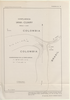
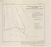
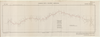
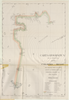
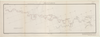
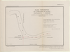
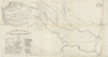
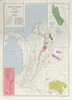
Croquis de los rios Napo y Putumayo. Geografía Militar del Perú. NOTA: Este croquis ha sido reconstruido por JORGE MARTINEZ L. y MANUEL JOSE PEÑA C.I.C con los datos, croquis y planos publicados por el Coronel Pedro Portillo en diferentes épocas; los señor Rafael E. Baluarte en 1905; los del señor Camilo Vallejos Z. en 1907, y el croquis del señor Victor Macedo que acompaña la obra EN EL PUTUMAYO Y SUS AFLUENTES, por Eugenio Robuchon. Concluido el trabajo de reconstrucción, ha sido confronttado con los informes del Ingeniero alemán von Hassel, sobre los VARADEROS o ARRASTRADEROS, y con los originales o cartera de ingeniero de Robuchon, que por muchos años se consideraron perdidos, pero ellos fueron facilitados al autor de GEOGRAFIA MILITAR DEL PERU, por el doctor Santiago Rozo. OBSEQUIO DE LA FABRICA DE LICORES Y PERFUMES DE CUNDINAMARCA
|
1930 | 11ヶ月 前 | 9個の基準点 |
|
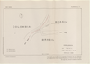
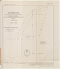
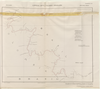
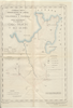
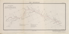
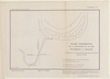
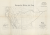
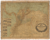
Mapa de la Región Hidrográfica del Amazonas Peruano CON SUS AFLUENTES NAVEGABLES. Mandado trazar por la SOCIEDAD GEOGRAFICA DE LIMA. Por MAX DOIG. PRIMER MAPA. OBSEQUI DE LA FABRICA DE LICORES Y PERFUMES DE CUNDINAMARCA
|
1930 | 11ヶ月 前 | 12個の基準点 |
|
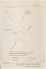
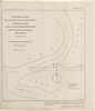
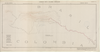
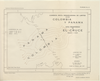
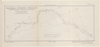
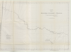
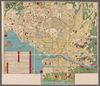
PLANO DEL RIO MAGDALENA QUE MUESTRA LA ZONA DE INUNDACION Y LOS LIMITES DEL CLIMA. JBK
|
1928 | 11ヶ月 前 | 14個の基準点 |
|
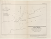
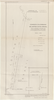
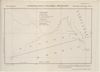
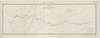
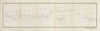
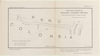
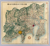
Gráfico para mostrar la densidad de la población y el volumen del tráfico anual en las distintas vías fluviales, ferrocarriles y cables en la REPUBLICA DE COLOMBIA. Corresponde a los datos del año 1923. Konsortium de Julius Berger. Agosto 1924
|
1928 | 11ヶ月 前 | 12個の基準点 |
|
|
1939 | 11ヶ月 前 | 24個の基準点 |
|
|
2023 | 1年以上 前 | 15個の基準点 |
|
講義の課題で作成したものです。
リンク: 出所・参照情報
|
2024 | 2ヶ月 前 | 3個の基準点 |
|
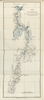
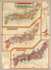
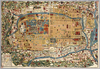
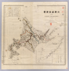
【Courtesy of the C. V. Starr East Asian Library University of California, Berkeley】 1 map : col. ; 70 x 77 cm., folded in cover 19 x 14 cm. Mounted cover title. Title on map: Fujimi jusanshu yochi zenzu. Copper plate print. In Japanese. Relief shown pictorially. Includes legend. East Asian Library call number: D69.
リンク: 出所・参照情報
|
1886 | 3年以上 前 | 4個の基準点 |
|
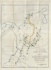
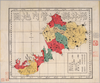
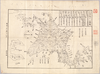
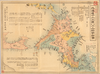
【Courtesy of the C. V. Starr East Asian Library University of California, Berkeley】 Japanese date Meiji 10 1877. In color. Folded. 3 maps on one sheet.Copperplate print. In Japanese. Oriented with north to the upper right. Relief shown by hachures. Contents: Kokugun kubunzu ; Fuken kankatsu saibansho kukaizu ; Zenkoku chimei sansen meisaizu. 2 insets: Ryūkyū Shotō zu ; Ogasawara zentō zu. 1 ancillary map: Hokkaidō oyobi Chishima Zentō zu. Includes charts of mountains and rivers , preface and legend.
リンク: 出所・参照情報
|
1877 | 4年弱 前 | 4個の基準点 |
|
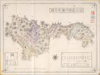
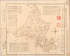
【Courtesy of the C. V. Starr East Asian Library University of California, Berkeley】 Mounted cover title. Title on map: Fukui-ken kannai chizu. Wood block print. In Japanese. Relief shown by hachures.
リンク: 出所・参照情報
|
1883 | 3年以上 前 | 4個の基準点 |
|
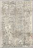
【Courtesy of the C. V. Starr East Asian Library University of California, Berkeley】 Mounted cover title. Copperplate print. In Japanese. Oriented with north to the lower left. Relief shown by hachures. Includes legend.
リンク: 出所・参照情報
|
1889 | 3年以上 前 | 4個の基準点 |
|
【Courtesy of the C. V. Starr East Asian Library University of California, Berkeley】 Japanese date Genji 1 1864. Folded. Mounted cover title. Wood block print. In Japanese. Relief shown pictorially. Includes distance chart. Shows land tenures of daimyo.
リンク: 出所・参照情報
|
1864 | 4年弱 前 | 4個の基準点 |
|
【Courtesy of the C. V. Starr East Asian Library University of California, Berkeley】 Japanese date Genji 1 1864. In color. Folded. Mounted cover title. Wood block print. Oriented with north to the left. In Japanese. Relief shown pictorially. Includes legend.
リンク: 出所・参照情報
|
1864 | 4年弱 前 | 4個の基準点 |
|
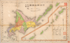
【Courtesy of the C. V. Starr East Asian Library University of California, Berkeley】 Mounted cover title. Copperplate print. In Japanese. Relief shown by hachures. Includes 1 inset: Maebashi shigaizu. Includes populations, text, preface and legend. List of districts pasted on the left of map.
リンク: 出所・参照情報
|
1879 | 3年以上 前 | 23個の基準点 |
|
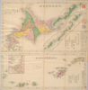
【Courtesy of the C. V. Starr East Asian Library University of California, Berkeley】 Japanese date Tenmei 7 1787. In color. Folded. Mounted cover title. Wood block print. In Japanese. Oriented with north to the right. Relief shown pictorially. Includes legend. Shows the western part of Lake Biwa.
リンク: 出所・参照情報
|
1878 | 4年弱 前 | 4個の基準点 |
|
【Courtesy of the C. V. Starr East Asian Library University of California, Berkeley】 Folded to 18 x 13 cm. Wood block print. In Japanese. Oriented with north to the left. Relief shown pictorially. Includes list of kuni and legend. East Asian Library call number D3.
リンク: 出所・参照情報
|
1870 | 3年以上 前 | 4個の基準点 |
|
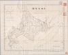
【Courtesy of the C. V. Starr East Asian Library University of California, Berkeley】 1 map : col. ; 77 x 75 cm., folded in cover 23 x 16 cm. Mounted cover title. Copperplate print. In Japanese, English and romanized Japanese. Relief shown by hachures. Includes 1 inset and legend. East Asian Library call number: D8.
リンク: 出所・参照情報
|
1883 | 3年以上 前 | 4個の基準点 |
|
【Courtesy of the C. V. Starr East Asian Library University of California, Berkeley】 Mounted cover title. Title on map: Hokkaido 12-kakoku 86-gun meisaizu. Wood block print. In Japanese. Oriented with north to the left. Includes distance chart and legend. Col. map folded in cover 19 x 10 cm. East Asian Library call number D2.
リンク: 出所・参照情報
|
1869 | 3年以上 前 | 4個の基準点 |
|
【Courtesy of the C. V. Starr East Asian Library University of California, Berkeley】 Col. map folded in cover 14 x 9 cm. Copperplate print. In Japanese. Oriented with north to the left. Includes distance chart and legend. "Hakodate shinbun dai kyuhyakunanajunigo hatsuzuri furoku." East Asian Library call number D9.
リンク: 出所・参照情報
|
1884 | 3年以上 前 | 4個の基準点 |
|
【Courtesy of the C. V. Starr East Asian Library University of California, Berkeley】 Contents :1 Hokkaido ansha yakuzu -- 2 Ryukyu Shoto ansha yakuzu. Mounted cover title. Copperplate print. In Japanese. Relief shown by hachures. Oriented with north to the upper right. Includes 2 insets. 2 maps on 1 sheet : col.; 19 x 48 cm.and 28 x 48 cm. on sheet 53 x 51 cm., folded in cover 18 x 13 cm. East Asian Library call number Cb41.
リンク: 出所・参照情報
|
1876 | 3年以上 前 | 4個の基準点 |
|
【Courtesy of the C. V. Starr East Asian Library University of California, Berkeley】 Col. map folded in cover 18 x 13 cm. Mounted cover title. Title on map: Nihon ansha yakuzu : Hokkaido hokubu. Copperplate print. In Japanese. Relief shown by hachures. Includes 1 inset and legend. East Asian Library call number D6.
リンク: 出所・参照情報
|
1879 | 3年以上 前 | 4個の基準点 |
|
【Courtesy of the C. V. Starr East Asian Library University of California, Berkeley】
リンク: 出所・参照情報
|
1868 | 3年以上 前 | 4個の基準点 |