地図を見る
| 地図 | タイトル | 年 | 前回の更新  |
ステータス |
|---|---|---|---|---|
|
|
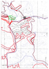
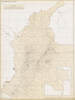
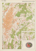
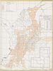
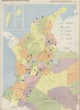
2022 | 3年以上 前 | 7個の基準点 |
|
|
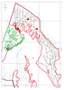
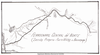
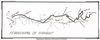
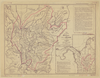
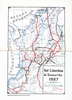
2022 | 3年以上 前 | 12個の基準点 |

|
|
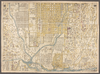
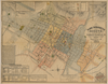
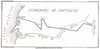
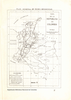
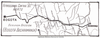
2022 | 3年以上 前 | 6個の基準点 |
|
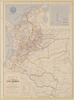
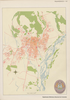
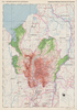
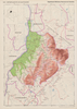
立命館大学古地図データベースより引用
|
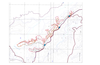
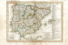
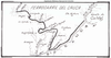
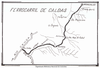
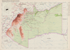
3年以上 前 | 156個の基準点 | |
|
1
|
2022 | 3年以上 前 | 5個の基準点 |

|
208
|
2022 | 3年以上 前 | 3個の基準点 |
|
リンク: 出所・参照情報
|
2020 | 3年以上 前 | 4個の基準点 |
|
リンク: 出所・参照情報
|
2020 | 3年以上 前 | 3個の基準点 |
|
|
2022 | 3年以上 前 | 3個の基準点 |
|
リンク: 出所・参照情報
|
2020 | 3年以上 前 | 3個の基準点 |
|
リンク: 出所・参照情報
|
2020 | 3年以上 前 | 8個の基準点 |
|
リンク: 出所・参照情報
|
2020 | 3年以上 前 | 9個の基準点 |
|
リンク: 出所・参照情報
|
2020 | 3年以上 前 | 4個の基準点 |
|
リンク: 出所・参照情報
|
2020 | 3年以上 前 | 9個の基準点 |
|
リンク: 出所・参照情報
|
2020 | 3年以上 前 | 8個の基準点 |
|
リンク: 出所・参照情報
|
2021 | 3年以上 前 | 7個の基準点 |
|
|
3年以上 前 | 31個の基準点 | |
|
リンク: 出所・参照情報
|
2020 | 3年以上 前 | 5個の基準点 |
|
リンク: 出所・参照情報
|
2020 | 3年以上 前 | 14個の基準点 |
|
リンク: 出所・参照情報
|
2021 | 3年以上 前 | 8個の基準点 |
|
リンク: 出所・参照情報
|
2020 | 3年以上 前 | 17個の基準点 |
|
リンク: 出所・参照情報
|
2020 | 3年以上 前 | 5個の基準点 |
|
リンク: 出所・参照情報
|
2021 | 3年以上 前 | 12個の基準点 |
|
リンク: 出所・参照情報
|
2020 | 3年以上 前 | 4個の基準点 |
|
リンク: 出所・参照情報
|
2020 | 3年以上 前 | 4個の基準点 |
|
リンク: 出所・参照情報
|
2020 | 3年以上 前 | 50個の基準点 |
|
リンク: 出所・参照情報
|
2020 | 3年以上 前 | 5個の基準点 |
|
リンク: 出所・参照情報
|
2020 | 3年以上 前 | 11個の基準点 |
|
リンク: 出所・参照情報
|
2020 | 3年以上 前 | 13個の基準点 |
|
リンク: 出所・参照情報
|
2020 | 3年以上 前 | 13個の基準点 |
|
リンク: 出所・参照情報
|
2020 | 3年以上 前 | 20個の基準点 |
|
リンク: 出所・参照情報
|
2020 | 3年以上 前 | 3個の基準点 |
|
リンク: 出所・参照情報
|
2020 | 3年以上 前 | 9個の基準点 |
|
リンク: 出所・参照情報
|
2020 | 3年以上 前 | 12個の基準点 |
|
リンク: 出所・参照情報
|
2020 | 3年以上 前 | 3個の基準点 |
|
リンク: 出所・参照情報
|
2020 | 3年以上 前 | 44個の基準点 |
|
リンク: 出所・参照情報
|
2020 | 3年以上 前 | 11個の基準点 |
|
リンク: 出所・参照情報
|
2020 | 3年以上 前 | 17個の基準点 |
|
リンク: 出所・参照情報
|
2020 | 3年以上 前 | 15個の基準点 |
|
|
2022 | 3年以上 前 | 8個の基準点 |
|
リンク: 出所・参照情報
|
2020 | 3年以上 前 | 5個の基準点 |
|
リンク: 出所・参照情報
|
2020 | 3年以上 前 | 11個の基準点 |
|
リンク: 出所・参照情報
|
2020 | 3年以上 前 | 5個の基準点 |
|
リンク: 出所・参照情報
|
2020 | 3年以上 前 | 3個の基準点 |
|
リンク: 出所・参照情報
|
2020 | 3年以上 前 | 9個の基準点 |
|
リンク: 出所・参照情報
|
2020 | 3年以上 前 | 22個の基準点 |
|
リンク: 出所・参照情報
|
2020 | 3年以上 前 | 15個の基準点 |
|
リンク: 出所・参照情報
|
2020 | 3年以上 前 | 3個の基準点 |
|
リンク: 出所・参照情報
|
2020 | 3年以上 前 | 4個の基準点 |
|
リンク: 出所・参照情報
|
2020 | 3年以上 前 | 12個の基準点 |