最終更新日時 約1ヶ月 前. 作成 : 1920
200枚の地図 (200枚の地図 rectified 100%)
KMLをダウンロードする |
|
|
北海道旧版地形図(1/5万)
最終更新日時 約1ヶ月 前. 作成 : 1920 200枚の地図 (200枚の地図 rectified 100%) KMLをダウンロードする | |

| 地図 | タイトル | 年 | 前回の更新 | ステータス |
|---|---|---|---|---|
|
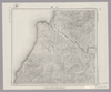
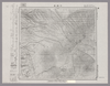
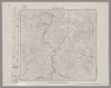
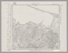
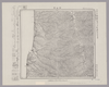
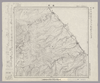
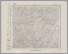
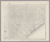
Image from the Map Collections courtesy Stanford University Libraries, licensed under a Creative Commons Attribution-Noncommercial 3.0 Unported License. © Stanford University. 【図幅名】 滝川 【測量時期】 大正5年測図/昭和10年鉄道補入 【発行時期】 昭和11年8月発行 【記号】 留萌3号(共11面) 【測量機関】 大日本帝国陸地測量部 【備考】 ( 1枚のレイヤー)
リンク: 出所・参照情報
|
4ヶ月 前 | 4個の基準点 | |
|
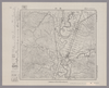
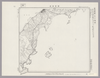
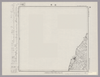
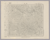
Image from the Map Collections courtesy Stanford University Libraries, licensed under a Creative Commons Attribution-Noncommercial 3.0 Unported License. © Stanford University. 【図幅名】 北見富士 【測量時期】 大正13年測図 【発行時期】 昭和4年6月発行 【記号】 淕別10号(共16面) 【測量機関】 大日本帝国陸地測量部 【備考】 ( 1枚のレイヤー)
リンク: 出所・参照情報
|
4ヶ月 前 | 4個の基準点 | |
|
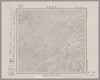
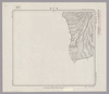
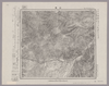
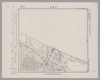
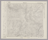
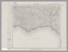
Image from the Map Collections courtesy Stanford University Libraries, licensed under a Creative Commons Attribution-Noncommercial 3.0 Unported License. © Stanford University. 【図幅名】 下富良野 【測量時期】 大正8年測図 【発行時期】 大正10年4月発行 【記号】 旭川12号(共16面) 【測量機関】 大日本帝国陸地測量部 【備考】 ( 1枚のレイヤー)
リンク: 出所・参照情報
|
4ヶ月 前 | 4個の基準点 | |
|
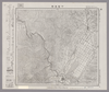
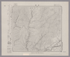
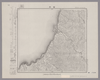
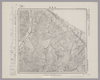
Image from the Map Collections courtesy Stanford University Libraries, licensed under a Creative Commons Attribution-Noncommercial 3.0 Unported License. © Stanford University. 【図幅名】 十勝岳 【測量時期】 大正10年測図 【発行時期】 【記号】 旭川8号(共16面) 【測量機関】 参謀本部 【備考】 秘 ( 1枚のレイヤー)
リンク: 出所・参照情報
|
4ヶ月 前 | 4個の基準点 | |
|
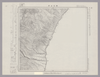
Image from the Map Collections courtesy Stanford University Libraries, licensed under a Creative Commons Attribution-Noncommercial 3.0 Unported License. © Stanford University. 【図幅名】 根室南部 【測量時期】 大正11年測図 【発行時期】 昭和11年1月発行 【記号】 根室近傍3号(共11面) 【測量機関】 参謀本部・陸地測量部 【備考】 根室5号(共5面) 仮製版 軍事極秘 ( 1枚のレイヤー)
リンク: 出所・参照情報
|
4ヶ月 前 | 4個の基準点 | |
|
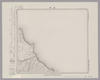
Image from the Map Collections courtesy Stanford University Libraries, licensed under a Creative Commons Attribution-Noncommercial 3.0 Unported License. © Stanford University. 【図幅名】 【測量時期】 【発行時期】 【記号】 【測量機関】 【備考】 ( 1枚のレイヤー)
リンク: 出所・参照情報
|
4ヶ月 前 | 4個の基準点 | |
|
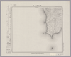
Image from the Map Collections courtesy Stanford University Libraries, licensed under a Creative Commons Attribution-Noncommercial 3.0 Unported License. © Stanford University. 【図幅名】 月形 【測量時期】 大正5年測図/昭和10年鉄道補入 【発行時期】 昭和11年2月発行 【記号】 留萌8号(共11面) 【測量機関】 大日本帝国陸地測量部 【備考】 ( 1枚のレイヤー)
リンク: 出所・参照情報
|
4ヶ月 前 | 4個の基準点 | |
|
Image from the Map Collections courtesy Stanford University Libraries, licensed under a Creative Commons Attribution-Noncommercial 3.0 Unported License. © Stanford University. 【図幅名】 上江丹別 【測量時期】 大正8年測図/昭和6年鉄道補入 【発行時期】 昭和8年1月発行 【記号】 旭川13号(共16面) 【測量機関】 大日本帝国陸地測量部 【備考】 ( 1枚のレイヤー)
リンク: 出所・参照情報
|
4ヶ月 前 | 4個の基準点 | |
|
Image from the Map Collections courtesy Stanford University Libraries, licensed under a Creative Commons Attribution-Noncommercial 3.0 Unported License. © Stanford University. 【図幅名】 留萌 【測量時期】 大正8年測図/昭和6年鉄道補入 【発行時期】 昭和7年9月発行 【記号】 留萌5号(共11面) 【測量機関】 大日本帝国陸地測量部 【備考】 ( 1枚のレイヤー)
リンク: 出所・参照情報
|
4ヶ月 前 | 4個の基準点 | |
|
Image from the Map Collections courtesy Stanford University Libraries, licensed under a Creative Commons Attribution-Noncommercial 3.0 Unported License. © Stanford University. 【図幅名】 白龍 【測量時期】 大正10年及大正12年測圖/昭和8年鐡道補入 【発行時期】 【記号】 陸別十三号 【測量機関】 参謀本部 【備考】 祕 假製版 ( 1枚のレイヤー)
リンク: 出所・参照情報
|
4ヶ月 前 | 4個の基準点 | |
|
Image from the Map Collections courtesy Stanford University Libraries, licensed under a Creative Commons Attribution-Noncommercial 3.0 Unported License. © Stanford University. 【図幅名】 春苅古丹 【測量時期】 大正13年測圖 【発行時期】 【記号】 標津十三号 【測量機関】 参謀本部 【備考】 祕 假製版 ( 1枚のレイヤー)
リンク: 出所・参照情報
|
4ヶ月 前 | 4個の基準点 | |
|
Image from the Map Collections courtesy Stanford University Libraries, licensed under a Creative Commons Attribution-Noncommercial 3.0 Unported License. © Stanford University. 【図幅名】 サロマ湖 【測量時期】 大正13年測圖 【発行時期】 【記号】 紋別四号 【測量機関】 参謀本部 【備考】 祕 假製版 ( 1枚のレイヤー)
リンク: 出所・参照情報
|
4ヶ月 前 | 4個の基準点 | |
|
Image from the Map Collections courtesy Stanford University Libraries, licensed under a Creative Commons Attribution-Noncommercial 3.0 Unported License. © Stanford University. 【図幅名】 上渚滑 【測量時期】 大正12年測図 【発行時期】 昭和13年10月発行 【記号】 紋別11号(共11面) 【測量機関】 大日本帝国陸地測量部 【備考】 仮製版 ( 1枚のレイヤー)
リンク: 出所・参照情報
|
4ヶ月 前 | 4個の基準点 | |
|
Image from the Map Collections courtesy Stanford University Libraries, licensed under a Creative Commons Attribution-Noncommercial 3.0 Unported License. © Stanford University. 【図幅名】 中湧別 【測量時期】 大正13年測圖 【発行時期】 【記号】 紋別七号 【測量機関】 参謀本部 【備考】 祕 假製版 ( 1枚のレイヤー)
リンク: 出所・参照情報
|
4ヶ月 前 | 4個の基準点 | |
|
Image from the Map Collections courtesy Stanford University Libraries, licensed under a Creative Commons Attribution-Noncommercial 3.0 Unported License. © Stanford University. 【図幅名】 沢木 【測量時期】 大正12年測図 【発行時期】 昭和13年10月発行 【記号】 紋別13号(共11面) 【測量機関】 大日本帝国陸地測量部 【備考】 仮製版 ( 1枚のレイヤー)
リンク: 出所・参照情報
|
4ヶ月 前 | 4個の基準点 | |
|
Image from the Map Collections courtesy Stanford University Libraries, licensed under a Creative Commons Attribution-Noncommercial 3.0 Unported License. © Stanford University. 【図幅名】 初山別 【測量時期】 大正12年測図 【発行時期】 大正13年8月発行 【記号】 羽幌1号(共8面) 【測量機関】 大日本帝国陸地測量部 【備考】 仮製版 ( 1枚のレイヤー)
リンク: 出所・参照情報
|
4ヶ月 前 | 4個の基準点 | |
|
Image from the Map Collections courtesy Stanford University Libraries, licensed under a Creative Commons Attribution-Noncommercial 3.0 Unported License. © Stanford University. 【図幅名】 羽幌 【測量時期】 大正11年測図/昭和8年鉄道補入 【発行時期】 昭和9年10月発行 【記号】 羽幌6号(共8面) 【測量機関】 大日本帝国陸地測量部 【備考】 仮製版 ( 1枚のレイヤー)
リンク: 出所・参照情報
|
4ヶ月 前 | 4個の基準点 | |
|
Image from the Map Collections courtesy Stanford University Libraries, licensed under a Creative Commons Attribution-Noncommercial 3.0 Unported License. © Stanford University. 【図幅名】 上興部 【測量時期】 大正12年測図 【発行時期】 大正13年6月発行 【記号】 名寄2号(共16面) 【測量機関】 大日本帝国陸地測量部 【備考】 仮製版 ( 1枚のレイヤー)
リンク: 出所・参照情報
|
4ヶ月 前 | 4個の基準点 | |
|
Image from the Map Collections courtesy Stanford University Libraries, licensed under a Creative Commons Attribution-Noncommercial 3.0 Unported License. © Stanford University. 【図幅名】 紋別 【測量時期】 大正12年測図 【発行時期】 昭和13年10月発行 【記号】 紋別10号(共11面) 【測量機関】 大日本帝国陸地測量部 【備考】 仮製版 ( 1枚のレイヤー)
リンク: 出所・参照情報
|
4ヶ月 前 | 4個の基準点 | |
|
Image from the Map Collections courtesy Stanford University Libraries, licensed under a Creative Commons Attribution-Noncommercial 3.0 Unported License. © Stanford University. 【図幅名】 雄武 【測量時期】 大正12年測図 【発行時期】 大正13年6月発行 【記号】 名寄1号(共16面) 【測量機関】 大日本帝国陸地測量部 【備考】 仮製版 ( 1枚のレイヤー)
リンク: 出所・参照情報
|
4ヶ月 前 | 4個の基準点 | |
|
Image from the Map Collections courtesy Stanford University Libraries, licensed under a Creative Commons Attribution-Noncommercial 3.0 Unported License. © Stanford University. 【図幅名】 狩太 【測量時期】 大正6年測圖 【発行時期】 【記号】 岩内八号 【測量機関】 参謀本部 【備考】 祕 ( 1枚のレイヤー)
リンク: 出所・参照情報
|
4ヶ月 前 | 4個の基準点 | |
|
Image from the Map Collections courtesy Stanford University Libraries, licensed under a Creative Commons Attribution-Noncommercial 3.0 Unported License. © Stanford University. 【図幅名】 鹿部 【測量時期】 大正4年測圖 【発行時期】 【記号】 室蘭四号 【測量機関】 参謀本部 【備考】 祕 ( 1枚のレイヤー)
リンク: 出所・参照情報
|
4ヶ月 前 | 4個の基準点 | |
|
Image from the Map Collections courtesy Stanford University Libraries, licensed under a Creative Commons Attribution-Noncommercial 3.0 Unported License. © Stanford University. 【図幅名】 奥尻西南部 【測量時期】 大正6年測圖 【発行時期】 【記号】 久遠十二号 【測量機関】 参謀本部 【備考】 祕 ( 1枚のレイヤー)
リンク: 出所・参照情報
|
4ヶ月 前 | 4個の基準点 | |
|
Image from the Map Collections courtesy Stanford University Libraries, licensed under a Creative Commons Attribution-Noncommercial 3.0 Unported License. © Stanford University. 【図幅名】 遊楽部岳 【測量時期】 大正6年測図 【発行時期】 大正8年12月発行 【記号】 室蘭15号(共14面) 【測量機関】 大日本帝国陸地測量部 【備考】 ( 1枚のレイヤー)
リンク: 出所・参照情報
|
4ヶ月 前 | 4個の基準点 | |
|
Image from the Map Collections courtesy Stanford University Libraries, licensed under a Creative Commons Attribution-Noncommercial 3.0 Unported License. © Stanford University. 【図幅名】 春立 【測量時期】 大正8年測圖 【発行時期】 【記号】 浦河十一号 【測量機関】 参謀本部 【備考】 祕 ( 1枚のレイヤー)
リンク: 出所・参照情報
|
4ヶ月 前 | 4個の基準点 | |
|
Image from the Map Collections courtesy Stanford University Libraries, licensed under a Creative Commons Attribution-Noncommercial 3.0 Unported License. © Stanford University. 【図幅名】 苫小牧 【測量時期】 大正8年測圖/昭和10年修正測圖 【発行時期】 【記号】 苫小牧五号 【測量機関】 参謀本部 【備考】 祕 ( 1枚のレイヤー)
リンク: 出所・参照情報
|
4ヶ月 前 | 4個の基準点 | |
|
Image from the Map Collections courtesy Stanford University Libraries, licensed under a Creative Commons Attribution-Noncommercial 3.0 Unported License. © Stanford University. 【図幅名】 長万部 【測量時期】 大正6年測圖/昭和3年鐡道補入 【発行時期】 【記号】 室蘭九号 【測量機関】 参謀本部 【備考】 祕 ( 1枚のレイヤー)
リンク: 出所・参照情報
|
4ヶ月 前 | 4個の基準点 | |
|
Image from the Map Collections courtesy Stanford University Libraries, licensed under a Creative Commons Attribution-Noncommercial 3.0 Unported License. © Stanford University. 【図幅名】 音別 【測量時期】 大正9年測図 【発行時期】 大正11年3月発行 【記号】 帯広3号(共16面) 【測量機関】 大日本帝国陸地測量部 【備考】 ( 1枚のレイヤー)
リンク: 出所・参照情報
|
4ヶ月 前 | 4個の基準点 | |
|
Image from the Map Collections courtesy Stanford University Libraries, licensed under a Creative Commons Attribution-Noncommercial 3.0 Unported License. © Stanford University. 【図幅名】 厚内 【測量時期】 大正9年測圖 【発行時期】 【記号】 帯広四号 【測量機関】 参謀本部 【備考】 祕 ( 1枚のレイヤー)
リンク: 出所・参照情報
|
4ヶ月 前 | 4個の基準点 | |
|
Image from the Map Collections courtesy Stanford University Libraries, licensed under a Creative Commons Attribution-Noncommercial 3.0 Unported License. © Stanford University. 【図幅名】 焼尻島 【測量時期】 大正11年測図 【発行時期】 大正13年5月発行 【記号】 羽幌10号(共8面) 【測量機関】 大日本帝国陸地測量部 【備考】 仮製版 ( 1枚のレイヤー)
リンク: 出所・参照情報
|
4ヶ月 前 | 4個の基準点 |
 WMS CapabilitiesのURL
 タイル(Google・OSMのフォーマット)