最終更新日時 5ヶ月 前. 作成 :
53枚の地図 (53枚の地図 rectified 100%)
KMLをダウンロードする |
|
|
五万分一地形圖
最終更新日時 5ヶ月 前. 作成 : 53枚の地図 (53枚の地図 rectified 100%) KMLをダウンロードする | |

| 地図 | タイトル | 年 | 前回の更新 | ステータス |
|---|---|---|---|---|
|
|
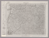
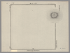
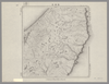
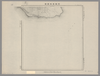
Image from the Map Collections courtesy Stanford University Libraries, licensed under a Creative Commons Attribution-Noncommercial 3.0 Unported License. © Stanford University. 【図幅名】 松山北部 【測量時期】 明治36年測図/昭和37年修正 【発行時期】 昭和6年8月発行 【記号】 松山1号(共15面) 【測量機関】 大日本帝国陸地測量部 【備考】 ( 2枚のレイヤー)
リンク: 出所・参照情報
|
5ヶ月 前 | 4個の基準点 | |
|
この地図の作成に当たっては、国土地理院長の承認を得て、同院発行の20万分の1地勢図及び5万分の1地形図を使用した。(承認番号 平30情使、 第1148号) ( 2枚のレイヤー)
リンク: 出所・参照情報
|
1947 | 5ヶ月 前 | 4個の基準点 |
|
この地図の作成に当たっては、国土地理院長の承認を得て、同院発行の20万分の1地勢図及び5万分の1地形図を使用した。(承認番号 平30情使、 第1148号) ( 2枚のレイヤー)
リンク: 出所・参照情報
|
1948 | 5ヶ月 前 | 4個の基準点 |
|
Image from the Map Collections courtesy Stanford University Libraries. This item is in the public domain. There are no restrictions on use.
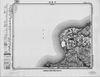
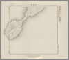
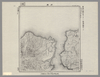
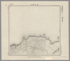
【図幅名】 後鏃岳【測量時期】 大正3年測圖 【発行時期】大正13年 【記号】 幌筵島十五号 【測量機関】 参謀本部 【その他】千島列島 陸地測量部 ( 1枚のレイヤー)
リンク: 出所・参照情報
|
1924 | 5ヶ月 前 | 4個の基準点 |
|
Image from the Map Collections courtesy Stanford University Libraries. This item is in the public domain. There are no restrictions on use.
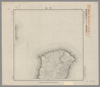
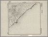
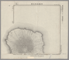
【図幅名】 雷公計島【測量時期】 大正6年測圖 【発行時期】昭和11年 【記号】 松輪島十五号 【測量機関】 参謀本部 【その他】千島列島 陸地測量部 ( 1枚のレイヤー)
リンク: 出所・参照情報
|
1936 | 5ヶ月 前 | 4個の基準点 |
|
Image from the Map Collections courtesy Stanford University Libraries. This item is in the public domain. There are no restrictions on use.
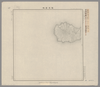
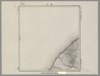
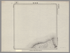
【図幅名】 乙女灣【測量時期】 大正5年測圖 【発行時期】昭和11年 【記号】 捨子古丹島十六号 【測量機関】 参謀本部 【その他】千島列島 陸地測量部 ( 1枚のレイヤー)
リンク: 出所・参照情報
|
1936 | 5ヶ月 前 | 5個の基準点 |
|
Image from the Map Collections courtesy Stanford University Libraries. This item is in the public domain. There are no restrictions on use.
【図幅名】 黑嶽【測量時期】 大正5年測圖 【発行時期】昭和11年 【記号】 捨子古丹島十五号 【測量機関】 参謀本部 【その他】千島列島 陸地測量部 ( 1枚のレイヤー)
リンク: 出所・参照情報
|
1936 | 5ヶ月 前 | 4個の基準点 |
|
Image from the Map Collections courtesy Stanford University Libraries. This item is in the public domain. There are no restrictions on use.
【図幅名】 越渇麿嶋【測量時期】 大正5年測圖 【発行時期】昭和11年 【記号】 知林古丹島三号 【測量機関】 参謀本部 【その他】千島列島 陸地測量部 ( 1枚のレイヤー)
リンク: 出所・参照情報
|
1936 | 5ヶ月 前 | 4個の基準点 |
|
Image from the Map Collections courtesy Stanford University Libraries. This item is in the public domain. There are no restrictions on use.
【図幅名】 寶珠山【測量時期】 大正4年測圖 【発行時期】昭和11年 【記号】 捨子古丹島一号 【測量機関】 参謀本部 【その他】千島列島 陸地測量部 ( 1枚のレイヤー)
リンク: 出所・参照情報
|
1936 | 5ヶ月 前 | 4個の基準点 |
|
Image from the Map Collections courtesy Stanford University Libraries. This item is in the public domain. There are no restrictions on use.
【図幅名】 新知灣 【測量時期】 大正5年測圖 【発行時期】昭和11年 【記号】 新知島十一号 【測量機関】 参謀本部【その他】千島列島 陸地測量部 ( 1枚のレイヤー)
リンク: 出所・参照情報
|
1936 | 5ヶ月 前 | 4個の基準点 |
|
Image from the Map Collections courtesy Stanford University Libraries. This item is in the public domain. There are no restrictions on use.
【図幅名】 羅處和島【測量時期】 大正6年測圖 【発行時期】昭和11年 【記号】 羅處和島二号 【測量機関】 参謀本部 【その他】千島列島 陸地測量部 ( 1枚のレイヤー)
リンク: 出所・参照情報
|
1936 | 5ヶ月 前 | 4個の基準点 |
|
Image from the Map Collections courtesy Stanford University Libraries. This item is in the public domain. There are no restrictions on use.
【図幅名】 松輪島 【測量時期】 大正6年測圖 【発行時期】昭和11年 【記号】 松輪島十七号 【測量機関】 参謀本部 【その他】千島列島 陸地測量部 ( 1枚のレイヤー)
リンク: 出所・参照情報
|
1936 | 5ヶ月 前 | 5個の基準点 |
|
Image from the Map Collections courtesy Stanford University Libraries. This item is in the public domain. There are no restrictions on use.
【図幅名】 新知嶽 【測量時期】 大正5年測圖 【発行時期】昭和11年 【記号】 新知島十二号 【測量機関】 参謀本部 【その他】千島列島 陸地測量部 ( 1枚のレイヤー)
リンク: 出所・参照情報
|
1936 | 5ヶ月 前 | 4個の基準点 |
|
Image from the Map Collections courtesy Stanford University Libraries. This item is in the public domain. There are no restrictions on use.
【図幅名】 計吐夷島 【測量時期】 大正6年測圖 【発行時期】昭和11年 【記号】 羅処和島八号、十二号、新知島一号【測量機関】 参謀本部 【その他】千島列島 陸地測量部 ( 1枚のレイヤー)
リンク: 出所・参照情報
|
1936 | 5ヶ月 前 | 4個の基準点 |
|
Image from the Map Collections courtesy Stanford University Libraries. This item is in the public domain. There are no restrictions on use.
【図幅名】 武魯頓灣 【測量時期】 大正5年測圖 【発行時期】昭和11年 【記号】 新知島七号 【測量機関】 参謀本部 【その他】千島列島 陸地測量部 ( 1枚のレイヤー)
リンク: 出所・参照情報
|
1936 | 5ヶ月 前 | 14個の基準点 |
|
Image from the Map Collections courtesy Stanford University Libraries. This item is in the public domain. There are no restrictions on use.
【図幅名】 志林規嶋【測量時期】 大正3年測圖 【発行時期】大正13年 【記号】 幌筵島十五号 【測量機関】 参謀本部 【その他】千島列島 陸地測量部 ( 1枚のレイヤー)
リンク: 出所・参照情報
|
1924 | 5ヶ月 前 | 4個の基準点 |
|
Image from the Map Collections courtesy Stanford University Libraries. This item is in the public domain. There are no restrictions on use.
【図幅名】 加熊別【測量時期】 大正3年測圖 【発行時期】大正13年 【記号】 幌筵島六号 【測量機関】 参謀本部 【その他】千島列島 陸地測量部 ( 1枚のレイヤー)
リンク: 出所・参照情報
|
1924 | 5ヶ月 前 | 4個の基準点 |
|
Image from the Map Collections courtesy Stanford University Libraries. This item is in the public domain. There are no restrictions on use.
【図幅名】 速毛川【測量時期】 大正2年測圖 【発行時期】大正13年 【記号】 幌筵島二号 【測量機関】 参謀本部 【その他】千島列島 陸地測量部 ( 1枚のレイヤー)
リンク: 出所・参照情報
|
1924 | 5ヶ月 前 | 4個の基準点 |
|
Image from the Map Collections courtesy Stanford University Libraries. This item is in the public domain. There are no restrictions on use.
【図幅名】 千島鳥島【測量時期】 大正元年測圖 【発行時期】大正13年 【記号】 千島列島三号 【測量機関】 参謀本部 【その他】千島列島 陸地測量部 ( 1枚のレイヤー)
リンク: 出所・参照情報
|
1924 | 5ヶ月 前 | 4個の基準点 |

|
Image from the Map Collections courtesy Stanford University Libraries. This item is in the public domain. There are no restrictions on use.
【図幅名】 三子山【測量時期】 大正2年測圖 【発行時期】大正13年 【記号】 千島列島五号 【測量機関】 参謀本部 【その他】千島列島 陸地測量部 ( 1枚のレイヤー)
リンク: 出所・参照情報
|
1924 | 5ヶ月 前 | 4個の基準点 |
|
Image from the Map Collections courtesy Stanford University Libraries. This item is in the public domain. There are no restrictions on use.
【図幅名】 土美追川【測量時期】 大正2年測圖 【発行時期】大正13年 【記号】 千島列島八号 【測量機関】 参謀本部 【その他】千島列島 陸地測量部 ( 1枚のレイヤー)
リンク: 出所・参照情報
|
1924 | 5ヶ月 前 | 4個の基準点 |
|
Image from the Map Collections courtesy Stanford University Libraries. This item is in the public domain. There are no restrictions on use.
【図幅名】 別飛沼【測量時期】 大正元年測圖 【発行時期】大正13年 【記号】 千島列島二号 【測量機関】 参謀本部 【その他】千島列島 陸地測量部 ( 1枚のレイヤー)
リンク: 出所・参照情報
|
1924 | 5ヶ月 前 | 5個の基準点 |
|
Image from the Map Collections courtesy Stanford University Libraries. This item is in the public domain. There are no restrictions on use.
【図幅名】 片岡【測量時期】 大正2年測圖 【発行時期】大正13年 【記号】 千島列島四号 【測量機関】 参謀本部 【その他】千島列島 陸地測量部 ( 1枚のレイヤー)
リンク: 出所・参照情報
|
1924 | 5ヶ月 前 | 4個の基準点 |
|
Image from the Map Collections courtesy Stanford University Libraries. This item is in the public domain. There are no restrictions on use.
【図幅名】 海靣山【測量時期】 大正4年測圖 【発行時期】昭和11年 【記号】 千島列島五十号 【測量機関】 参謀本部 【その他】千島列島 陸地測量部 ( 1枚のレイヤー)
リンク: 出所・参照情報
|
1936 | 5ヶ月 前 | 4個の基準点 |
|
Image from the Map Collections courtesy Stanford University Libraries. This item is in the public domain. There are no restrictions on use.
【図幅名】 白川【測量時期】 大正2年測圖 【発行時期】大正13年 【記号】 千島列島七号 【測量機関】 参謀本部 【その他】千島列島 陸地測量部 ( 1枚のレイヤー)
リンク: 出所・参照情報
|
1924 | 5ヶ月 前 | 4個の基準点 |
|
Image from the Map Collections courtesy Stanford University Libraries. This item is in the public domain. There are no restrictions on use.
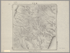
【図幅名】 阿頼度嶋南部【測量時期】 大正2年測圖 【発行時期】大正13年 【記号】 阿頼度嶋八号【測量機関】 参謀本部 【その他】千島列島 陸地測量部 ( 1枚のレイヤー)
リンク: 出所・参照情報
|
1924 | 5ヶ月 前 | 4個の基準点 |
|
Image from the Map Collections courtesy Stanford University Libraries. This item is in the public domain. There are no restrictions on use.
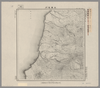
【図幅名】 大三頭山【測量時期】 大正4年測圖 【発行時期】昭和11年 【記号】 千島列島四十九号 【測量機関】 参謀本部 【その他】千島列島 陸地測量部 ( 1枚のレイヤー)
リンク: 出所・参照情報
|
1936 | 5ヶ月 前 | 4個の基準点 |
|
Image from the Map Collections courtesy Stanford University Libraries. This item is in the public domain. There are no restrictions on use.
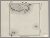
【図幅名】 阿頼度嶋北部【測量時期】 大正2年測圖 【発行時期】大正13年 【記号】 千島列島十一号 【測量機関】 参謀本部 【その他】千島列島 陸地測量部 ( 1枚のレイヤー)
リンク: 出所・参照情報
|
1924 | 5ヶ月 前 | 5個の基準点 |
|
Image from the Map Collections courtesy Stanford University Libraries. This item is in the public domain. There are no restrictions on use.
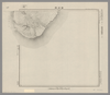
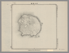
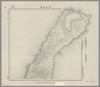
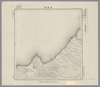
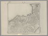
【図幅名】 國端崎【測量時期】 大正元年測圖 【発行時期】 【記号】 千島列島一号 【測量機関】 参謀本部 【その他】千島列島 陸地測量部 ( 1枚のレイヤー)
|
1912 | 5ヶ月 前 | 5個の基準点 |
|
Image from the Map Collections courtesy Stanford University Libraries. This item is in the public domain. There are no restrictions on use.
【図幅名】 鐘灣【測量時期】 大正4年測圖 【発行時期】昭和11年 【記号】 千島列島五十二号 【測量機関】 参謀本部 【その他】千島列島 陸地測量部 ( 1枚のレイヤー)
リンク: 出所・参照情報
|
2023 | 5ヶ月 前 | 4個の基準点 |
 WMS CapabilitiesのURL
 タイル(Google・OSMのフォーマット)