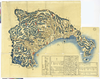
Owned by Sainsbury Institute for the Study of Japanese Arts and Cultures 【Atlas / Book Title】 【Engraver】 【Map Size】 72 x 98 cm 【Medium】 木版刷 Uploaded by ima. Depicts: 1840 Last modified over 5 years ago. 22 control points.
Tags
Links: Source / Biblio Ref | Download KML |
 WMS Capabilities URL
 Tiles (Google/OSM scheme)
 Download control points as CSV