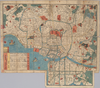
【Courtesy of the C. V. Starr East Asian Library University of California, Berkeley】 Title added by hand. Wood block print. In Japanese. Oriented with north to the right. Shows land tenures of daimyo and hatamoto, with some crests. Shows main temples and shrines pictorially. Includes distance chart and legend. Extension pasted on the bottom of map. Presumed date of publication is between 1844? and 1868. Uploaded by ima. Depicts: 1800 Last modified over 5 years ago. 3 control points.
Tags
Links: Source / Biblio Ref |
 WMS Capabilities URL
 Tiles (Google/OSM scheme)
 Download control points as CSV