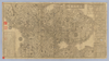
【Courtesy of the C. V. Starr East Asian Library University of California, Berkeley】 1 map ; 33 x 57 cm., folded in cover 18 x 9 cm. Copperplate print. In Japanese. Oriented with north to the left. Shows distance of sea routes and roads. Includes lists of daimyo and distances from main points. Includes legend. Title on map: Kaiho yochizu : Ise yori Awaji ni itaru. 1 map ; 33 x 57 cm, folded in cover 18 x 9 cm. East Asian Library call number D231. East Asian Library copy: small portions missing. Uploaded by ima. Depicts: 1858 Last modified over 7 years ago. Unrectified.
Tags
Links: Source / Biblio Ref |
 WMS Capabilities URL
 Tiles (Google/OSM scheme)
 Download control points as CSV