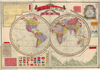
【Courtesy of the C. V. Starr East Asian Library University of California, Berkeley】 Mounted cover title. Copperplate print. In Japanese. Relief shown by hachures. Includes charts of mountains and rivers, distance chart, Includes charts of mountains and rivers, distance chart, and national flags. 1 map : col. ; 2 hemispheres each 27 cm. in diam., on sheet 49 x 70 cm., folded in cover 17 x 12 cm. East Asian Library call number A42. Uploaded by ima. Depicts: 1886 Last modified over 7 years ago. Unrectified.
Tags
Links: Source / Biblio Ref |
 WMS Capabilities URL
 Tiles (Google/OSM scheme)
 Download control points as CSV