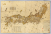
【Courtesy of the C. V. Starr East Asian Library University of California, Berkeley】 1 map : hand col. ; on sheet 83 x 126 cm., folded in cover 21 x 17 cm. Wood block print. In Japanese. Title from: Nihon chizushi / Akioka Takejiro. p. 147. Covers Matsumae to Tsushima and Ryukyu and Hachijojima. Preface by Shibano Ritsuzan in 1775. Oriented with north to the upper right. Shows longitude and latitude. Includes legend, explanation of tides, Ogasawara and Izu Shichito and text by the author. East Asian Library call number Ca-12. アップロード者: ima. 作成: 1779 最終更新日時 5年以上 前. 5個の基準点.
タグ
リンク: 出所・参照情報 | KMLをダウンロードする |
 WMS CapabilitiesのURL
 タイル(Google・OSMのフォーマット)
 基準点をCSVでダウンロードする