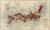
【Courtesy of the C. V. Starr East Asian Library University of California, Berkeley】 1 map : hand col. ; 85 x 140 cm., folded to 29 x 17 cm. Mounted cover title. Wood block print. In Japanese. Covers Matsumae to Tsushima, Yakushima, and Hachijojima. Oriented with north to the upper right. Preface by Shibano Ritsuzan. Engraved by Inoue Jihe. Shows longitude and latitude. Includes legend, distance chart of sea routes, and explanation of Kuroshio and tides. East Asian Library call number Ca 17.1. Uploaded by ima. Depicts: 1811 Last modified over 5 years ago. 5 control points.
Tags
Links: Source / Biblio Ref | Download KML |
 WMS Capabilities URL
 Tiles (Google/OSM scheme)
 Download control points as CSV