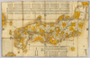
【Courtesy of the C. V. Starr East Asian Library University of California, Berkeley】 Description 1 map: hand col.; 76 x 119 cm., folded in cover 26 x 16 cm. Mounted cover title. Wood block print. In Japanese. Covers Matsumae to Tsushima, and Hachijojima. Shows distance of sea routes and kokudaka by province. Includes legend. East Asian Library call number Ca 22. Uploaded by ima. Depicts: 1700 Last modified over 5 years ago. 5 control points.
Tags
Links: Source / Biblio Ref | Download KML |
 WMS Capabilities URL
 Tiles (Google/OSM scheme)
 Download control points as CSV