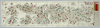
【Courtesy of the C. V. Starr East Asian Library University of California, Berkeley】 Cover title. Copperplate print. In Japanese. Orientation varies. Relief shown pictorially. Shows distance of roads and sea routes. Features hand tinted in red, green, and yellow. Includes 2 insets, list of prefectures, and legend. Folded to 19 x 8 cm. Uploaded by ima. Depicts: 1895 Last modified over 5 years ago. 4 control points.
Tags
Links: Source / Biblio Ref | Download KML |
 WMS Capabilities URL
 Tiles (Google/OSM scheme)
 Download control points as CSV