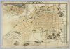
【Courtesy of the C. V. Starr East Asian Library University of California, Berkeley】 Lithograph In Japanese and English. Shows points of interest pictorially. 1 inset: Kōbe-kō no zu. Includes sketch map of Exhibition grounds and buildings on verso. Includes index of key government buildings, businesses, bridges, schools, and factories. Title on map: Daigokai Naikoku Kangyō Hakurankai kanran hikkei Ōsaka zenzu fu Kōbe = Bird's eye view of Osaka City and Harbor with map of Kobe. Folded to 27 x 14. アップロード者: ima. 作成: 1902 最終更新日時 5年以上 前. 4個の基準点.
タグ
リンク: 出所・参照情報 | KMLをダウンロードする |
 WMS CapabilitiesのURL
 タイル(Google・OSMのフォーマット)
 基準点をCSVでダウンロードする