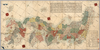
【Courtesy of the C. V. Starr East Asian Library University of California, Berkeley】 Japanese date Kaei 2 1849. In color. Folded. Wood block print. In Japanese. Oriented with north to the upper right. Covers Matsumae to Tsushima and Ryūkyū. Title from: Nihon chizushi / Akioka Takejirō. p.152. Shows longitudes and latitudes and Kuroshio. Includes distance chart and legend. Shows distances of the sea routes. Title on library's envelope. Uploaded by ima. Depicts: 1849 Last modified over 5 years ago. 5 control points.
Tags
Links: Source / Biblio Ref | Download KML |
 WMS Capabilities URL
 Tiles (Google/OSM scheme)
 Download control points as CSV