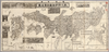
【Courtesy of the C. V. Starr East Asian Library University of California, Berkeley】 Japanese date Meiji 32 1899. Folded. Copperplate print. In Japanese. Oriented with north to the lower right. Relief shown by hachures. Includes 9 insets: Hokkaidō.--Taiwan zu.--Ryūkyū Chūhokubu Shotō ... et al. Includes views of points of interest, distance chart, and legend. Shows sea routes with distance. Uploaded by ima. Depicts: 1899 Last modified over 5 years ago. 5 control points.
Tags
Links: Source / Biblio Ref | Download KML |
 WMS Capabilities URL
 Tiles (Google/OSM scheme)
 Download control points as CSV