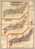
【Courtesy of the C. V. Starr East Asian Library University of California, Berkeley】 Japanese date Meiji 10 1877. In color. Folded. 3 maps on one sheet.Copperplate print. In Japanese. Oriented with north to the upper right. Relief shown by hachures. Contents: Kokugun kubunzu ; Fuken kankatsu saibansho kukaizu ; Zenkoku chimei sansen meisaizu. 2 insets: Ryūkyū Shotō zu ; Ogasawara zentō zu. 1 ancillary map: Hokkaidō oyobi Chishima Zentō zu. Includes charts of mountains and rivers , preface and legend. Uploaded by ima. Depicts: 1877 Last modified over 5 years ago. 4 control points.
Tags
Links: Source / Biblio Ref | Download KML |
 WMS Capabilities URL
 Tiles (Google/OSM scheme)
 Download control points as CSV