Japanese Map Warper

Log In Create Account
English (en)
Home > Maps > Map 4126
Bl 01 0167 jfqgxzbw 弘化丁未春三月二十四日信州大地震山_川塞湛水之図/弘化丁未夏四月十三日信州犀川崩激六郡漂蕩之図 Koka teimi sangatsu nijuvokka shinshu ojishin santai sensoku tansui no zu Map of the landslides, river blockages and floods caused by the earthquake in Shinano on 24.3.1847
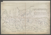
shelfmark: Maps 149.e.266 License: Public Domain 弘化4 *無刊記。外題「(弘化丁未)信濃国大地震山川崩激之図」。蔵書印「□□□原氏図書」。 Xylograph. Acquired 22 July 1868. Ex-Siebold. Uploaded by autobot. Depicts: 1847 Last modified over 4 years ago. Unrectified.
Tags British Library 大英図書館
Links: Source / Biblio Ref
Share |
Kml logo 20x25 Export

Metadata

Title
弘化丁未春三月二十四日信州大地震山_川塞湛水之図/弘化丁未夏四月十三日信州犀川崩激六郡漂蕩之図 Koka teimi sangatsu nijuvokka shinshu ojishin santai sensoku tansui no zu [Map of the landslides, river blockages and floods caused by the earthquake in Shinano on 24.3.1847]

Description
shelfmark: Maps 149.e.2(66) License: Public Domain 弘化4 *無刊記。外題「(弘化丁未)信濃国大地震山川崩激之図」。蔵書印「□□□原氏図書」。 Xylograph. Acquired 22 July 1868. Ex-Siebold.

Tags: British Library 大英図書館

is_map

Source / Bibliographic Ref URL
https://www.bl.uk/

Publisher

Author(s)
平田言編

Scale

Published Date

Reprint Date

修正を提案する