shelfmark: Maps 187.L.1.13 License: Public Domain 寛政写 *著者・書写年は大英図書館蔵『蝦夷群島図』(同筆)による。 Uploaded by autobot. Last modified over 6 years ago. Unrectified.
Tags
Links: Source / Biblio Ref |
|
|
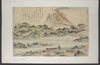
カヤケノホリ図(一日内浦岳) Kayakenohorizu Map of Mt Kayakenohori
shelfmark: Maps 187.L.1.13 License: Public Domain 寛政写 *著者・書写年は大英図書館蔵『蝦夷群島図』(同筆)による。 Uploaded by autobot. Last modified over 6 years ago. Unrectified. Tags Links: Source / Biblio Ref | |
 WMS Capabilities URL
 Tiles (Google/OSM scheme)
 Download control points as CSV